Maps of Giessen
Les Environs de Giesen et de Wetzlar
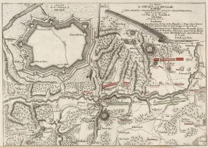
Plan Von der Stellung der Alliirten Armée unter Commando des Herzogs Ferdinand von Braunschweig, und des Französischen Generals Herzogs von Broglio ohnfern Giesen, vom 18. Septr. 1759. bis den 4. Jan. 1760
Ludwig Wilhelm (Hessen-Homburg, Landgraf)
Situations Karte von Giesen und denen Umliegenden Oertern

Meßtischblatt 5417 : Wetzlar, 1936
1 : 250000 Wetzlar. - Hrsg. 1892, einz. Nachtr. 1930, gedr. [19]36. - 1:25000. - [Berlin]: Reichsamt für Landesaufnahme, 1936. - 1 Kt.
Meßtischblatt 3165 : Wetzlar, 1892
1 : 250000 Wetzlar. - Aufn. 1890. - 1:25000. - [Berlin]: Kgl. Preuss. Landesaufnahme, 1892. - 1 Kt.
Meßtischblatt 3164 : Braunfels, 1911
1 : 250000 Braunfels. - Aufn. 1890, hrsg. 1892, bericht. 1911. - 1:25000. - [Berlin]: Kgl. Preuss. Landesaufnahme, 1911. - 1 Kt.
Meßtischblatt 3164 : Braunfels, 1892
1 : 250000 Braunfels. - Aufn. 1890. - 1:25000. - [Berlin]: Kgl. Preuss. Landesaufnahme, 1892. - 1 Kt.
Meßtischblatt 3106 : Rodheim (An der Bieber), 1892
1 : 250000 Rodheim (An der Bieber). - Aufn. 1890. - 1:25000. - [Berlin]: Kgl. Preuss. Landesaufnahme, 1892. - 1 Kt.
Meßtischblatt 3105 : Ballersbach, 1892
1 : 250000 Ballersbach. - Aufn. 1890. - 1:25000. - [Berlin]: Kgl. Preuss. Landesaufnahme, 1892. - 1 Kt.
Meßtischblatt 12Ballersbach
1 : 250000 Ballersbach. - Aufn. 1868. - 1:25000. - [Berlin]: Kgl. Preuss. Min. f. Handel, 1877. - 1 Kt.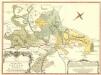
Plan des Hoch. Fvrst. Hess. Darmstattischen Oberamts Giesen
1 : 60000 Mollova mapová sbírka
Gegend von Giessen
Bergstraesser, G. H.
Meßtischblatt 16 : Merenberg, 1877
1 : 250000 Merenberg. - Aufn. 1868. - 1:25000. - [Berlin]: Kgl. Min. f. Handel, 1877. - 1 Kt.
Meßtischblatt 3104 : Herborn, 1907
1 : 250000 Herborn. - Aufn. 1905. - 1:25000. - [Berlin]: Reichsamt für Landesaufnahme, 1907. - 1 Kt.
Meßtischblatt 11 = 3104 : Herborn, 1877
1 : 250000 Herborn. - Aufn. 1868. - 1:25000. - [Berlin]: Kgl. Preuss. Min. f. Handel, 1877. - 1 Kt.
Meßtischblatt 5318 : Allendorf, 1938
1 : 250000 Allendorf. - Hrsg. 1909, letzte Nachtr. 1927, bericht. 1938. - 1:25000. - [Berlin]: Reichsamt für Landesaufnahme, 1938. - 1 Kt.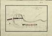
Camp de la Reserve du Duc de Broglie, prés Giesen le 6. Sept. 1759

Le Flambeau de la Guerre Allumee au Rhin
Mollova mapová sbírka Delisle, Guillaume Schenk, Peter II
[26] Sect. Wetzlar, uit: Geologische Karte der Rheinprovinz und der Provinz Westphalen / ausgeführt durch H. von Dechen
1 : 80000 titelvariant: Dechen's geologische Karte vom Rheinland und Westphalen; Annotatie: Titel op bladoverzicht; Incompleet Heinrich von Dechen Berlin : Schropp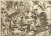
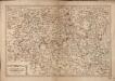
Comitatus Solms: Braunfelsensis et Greiffensteinensis adjacentiumq; quorundam locorum Vera
1 : 70000 Mollova mapová sbírka Simon, Johannes G.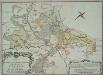
Plan des Hoch. Fvrst-Hess[isch] Darmstattischen Oberamts Giesen
1 : 60000
Meßtischblatt 3221 : Kleeberg, 1907
1 : 250000 Kleeberg. - Aufn. 1905. - 1:25000. - [Berlin]: Kgl. Preuss. Landesaufnahme, 1907. - 1 Kt.
Meßtischblatt 23 : Cleeberg, 1877
1 : 250000 Cleeberg. - Aufn. 1868. - 1:25000. - [Berlin]: Kgl. Min. f. Handel, 1877. - 1 Kt.
Meßtischblatt 3220 : Weilmünster, 1915
1 : 250000 Weilmünster. - Aufn. 1905, hrsg. 1907, Aufl.-dr. 1915. - 1:25000. - [Berlin]: Kgl. Preuss. Landesaufnahme, 1915. - 1 Kt.
Meßtischblatt 3220 : Weilmünster, 1907
1 : 250000 Weilmünster. - Aufn. 1905. - 1:25000. - [Berlin]: Kgl. Preuss. Landesaufnahme, 1907. - 1 Kt.
Meßtischblatt 3220 : Weilmünster, 1877
1 : 250000 Weilmünster. - Aufn. 1868. - 1:25000. - [Berlin]: Kgl. Min. f. Handel, 1877. - 1 Kt.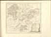
Les Environs De La Lahne depuis Marbvrg iusqu' à Ems avec les pais adiacents
1 : 200000
Wetteraviae
1 : 170000 Mollova mapová sbírka Stetter, Johann Jakob Stridbeck, Johann Baur, Johann