Maps of Le Val-de-Guéblange

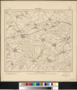
Meßtischblatt 3580 : Insmingen, 1916
1 : 250000 Insmingen. - Aufn. 1882, hrsg. 1883, Aufldr. 1916. - 1:25000. - [Berlin]: Reichsamt für Landesaufnahme, 1916. - 1 Kt.
Le Flambeau de la Guerre Allumee au Rhin
Mollova mapová sbírka Delisle, Guillaume Schenk, Peter II
Le Theatre de la Guerre Sur le Haut Rhein
1 : 142000 Mollova mapová sbírka Sanson, Guillaume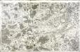
[Nancy]
1 Blatt : 60 x 91 cm Desfontaines s.n.
Carte Particuliere de Pays qui sont situéz entre le Rhein, la Saare, la Moselle, et la Basse Alsace
1 : 150000 Mollova mapová sbírka Jaillot, Alexis-Hubert Jaillot, Alexis Hubert
168. Pfalzburg, uit: Topographische Uebersichtskarte des Deutschen Reiches / herausgegeben v. d. Kartogr. Abt. d. Königl. Preuß. Landesaufnahme
1 : 200000 titelvariant: Topogr. Übersichtskarte des Deutschen Reiches; Annotatie: Titel boven bladen ook: Topogr. Übersichtskarte des Deutschen Reiches; Annotatie geografische gegevens: Op elk blad twee maatstokken: 10 Kilometer = 5,5 cm; 1 geogr. Meile = 3,6 cm; Legenda onder op elk blad Königlich Preußische Landesaufnahme. Kartographische Abtheilung [S.l : Königlich Preußische Landesaufnahme, Kartographische Abtheilung]
Partie Meridionale Des Pays Qui Sont Situéz Entre Le Rhein, La Saare, La Moselle Et La Basse Alsace
1 : 150000 Mollova mapová sbírka Mortier, Pieter Covens, Johannes I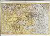
Partie meridionale du temporel de l'evesché de Metz
1 Karte : Kupferdruck ; 43 x 67 cm Jaillot Alexis-Hubert Jaillot
Lotharingia Septentrionalis Loraine vers le Seption.
1 : 330000 Mollova mapová sbírka Valk, Gerhard Schenk, Peter I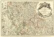
Les Estats du Duc de Lorraine ou sont les Duchez de Lorraine et de Bar :
1 : 180000 Mollova mapová sbírka Jaillot, Alexis-Hubert Jaillot, Alexis Hubert
Mediomatrici
1 Karte : Kupferdruck ; 43 x 50 cm Sanson chez l'auteur
Partie Meridionale Des Pays Qui Sont Situéz Entre Le Rhein, La Saare, La Moselle, Et La Basse Alsace. [Karte], in: Atlas nouveau, contenant toutes les parties du monde [...], Bd. 1, S. 241.
1 Karte aus Atlas Sanson, Nicolas Jaillot, Alexis Hubert und Mortier, Pieter
Nancy 126, uit: [W. Liebenow's Special-Karte von Mittel-Europa]
1 : 300000 titelvariant: W. Liebenow's Mittel-Europa; Annotatie: Titel boven de bladen: W. Liebenow's Mittel-Europa Johannes Wilhelm Liebenow 1822-1897 Hannover : Hermann Oppermann
Archid.conné de Sarbovrg dans l'Evesché de Metz
1 : 240000 Mollova mapová sbírka Sanson, Nicolas Mariette, Pierre Sanson, Nicolas
Mediomatrici
1 Karte : Kupferdruck ; 41 x 48 cm Sanson; Mariette chez P. Mariette
Nancy 126, uit: Special-Karte von Mittel-Europa / nach amtlichen Quellen bearbeitet von W. Liebenow
1 : 300000 titelvariant: W. Liebenow's Mittel-Europa; Annotatie: Titel boven de bladen: W. Liebenow's Mittel-Europa Johannes Wilhelm Liebenow 1822-1897 Frankfurt a. M. : Ludwig Ravenstein
Mediomatrici
1 Karte : Kupferdruck ; 41 x 48 cm Sanson; Robert de Vaugondy ches le Sr. Robert geog. du roi quai de l'horloge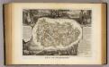
Dept. De La Meurthe.
1 : 395000 Levasseur, Victor.
Nova & Accurata delineatio geographica | EPISCOPATUS METENSIS | Quo ad Iurisdictionem temporalem
[Amsterdam : Joan Blaeu]
[Lotrinsko a Sársko]
Lotrinsko (Francie) Buna, Wilhelm C.
Le Theatre de Bellone :
Mollova mapová sbírka Schenk, Pieter Braakman, Adriaan
Mediomatrici
1 Karte : Kupferdruck ; 44 x 51 cm Sanson; Robert de Vaugondy chez l'auteur, chés le Sr. Robert geog. ord. du roi quai de l'horloge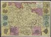
Carte du Duché de Lorraine, gravée sur les derniers memoires
1 : 600000 [Amsterdam] : [De La Feuille?]
[Atlas départemental : La France et ses colonies] No. 53 Meurthe
1 : 670000 publ. par Michel fils ainé [dressé par A. Lorrain, et gravé par H. Dandeleux] Versailles [etc.] : Barreswil et Andrieux
Département de la Meurte
1 Karte : Kupferdruck ; 48 x 48 cm Houdan au bureau de l'atlas national rue de la Harpe no. 26, et au dépôt du dit atlas rue de la Monnoye no. 5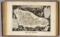
Dept. De La Moselle.
1 : 455000 Levasseur, Victor.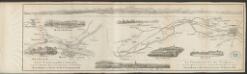
Alsatia inferior [Karte], in: Gerardi Mercatoris Atlas, sive, Cosmographicae meditationes de fabrica mundi et fabricati figura, S. 365.
1 Karte aus Atlas Mercator, Gerhard Montanus, Petrus
Lotharingia septentrionalis
1 Karte : Kupferdruck ; 36 x 47 cm Janssonius Joannes Janssonius
Alsatia inferior [Karte], in: Gerardi Mercatoris et I. Hondii Newer Atlas, oder, Grosses Weltbuch, Bd. 1, S. 244.
1 Karte aus Atlas Mercator, Gerhard und Hondius, Jodocus Jansson, Jan