Maps of gmina Skoki

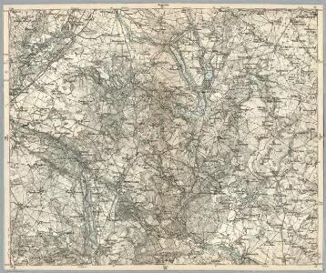
Composite: 276. Rogasen.
1 : 100000 Reichsamt fur Landesaufnahme
Meßtischblatt 3468 : Murowana-Goslin, 1940
1 : 250000 Murowana-Goslin. - Ausg. m. dt. Namen, letzte Nachtr. 1933, Ausg. m. vorläuf. Namensänd.. - 1:25000. - [Berlin]: Reichsamt für Landesaufnahme, 1940. - 1 Kt.
Meßtischblatt 3467 : Owinsk, 1940
1 : 250000 Owinsk. - Ausg. m. dt. Namen, letzte Nachtr. 1933, Ausg. m. vorläuf. Namensänd.. - 1:25000. - [Berlin]: Reichsamt für Landesaufnahme, 1940. - 1 Kt.
Meßtischblatt Welnau
1 : 250000 Welnau. - Ausg. m. dt. Namen, letzte Nachtr. 1932, Ausg. m. - 1:25000. - [Berlin]: Reichsamt für Landesaufnahme, 1940. - 1 Kt.
Meßtischblatt Welnau
1 : 250000 Welnau. - Ausg. m. dt. Namen, letzte Nachtr. 1932, Ausg. m. - 1:25000. - [Berlin]: Reichsamt für Landesaufnahme, 1940. - 1 Kt.
Meßtischblatt 3368 : Schokken, 1940
1 : 250000 Schokken. - Ausg. m. dt. Namen, letzte Nachtr. 1933. - 1:25000. - [Berlin]: Reichsamt für Landesaufnahme, 1940. - 1 Kt.
Meßtischblatt 3367 : Lukowo, 1940
1 : 250000 Lukowo. - Ausg. m. dt. Namen, letzte Nachtr. 1933. - 1:25000. - [Berlin]: Reichsamt für Landesaufnahme, 1940. - 1 Kt.
Meßtischblatt 3369 : Jabkowo, 1940
1 : 250000 Jabkowo. - Ausg. m. dt. Namen, letzte Nachtr. 1932, Ausg. m. vorläuf. Namensänd. - 1:25000. - [Berlin]: Reichsamt für Landesaufnahme, 1940. - 1 Kt.
Meßtischblatt 3267 : Bülowsthal, 1936
1 : 250000 Bülowsthal. - Aufn. 1888, letzte Nachtr. 1933/35. - 1:25000. - [Berlin]: Reichsamt für Landesaufnahme, 1936. - 1 Kt.
Meßtischblatt 3268 : Rogasen, 1936
1 : 250000 Rogasen. - Aufn. 1888, letzte Nachtr. 1933/35. - 1:25000. - [Berlin]: Reichsamt für Landesaufnahme, 1936. - 1 Kt.
Meßtischblatt 3269 : Mietschisko, 1936
1 : 250000 Mietschisko. - Aufn. 1888, hrsg. 1890, bericht. 1911, letzte Nachtr. 1933. - 1:25000. - [Berlin]: Reichsamt für Landesaufnahme, 1936. - 1 Kt.
80. Czarnikan, uit: Topographische Uebersichtskarte des Deutschen Reiches / herausgegeben v. d. Kartogr. Abt. d. Königl. Preuß. Landesaufnahme
1 : 200000 titelvariant: Topogr. Übersichtskarte des Deutschen Reiches; Annotatie: Titel boven bladen ook: Topogr. Übersichtskarte des Deutschen Reiches; Annotatie geografische gegevens: Op elk blad twee maatstokken: 10 Kilometer = 5,5 cm; 1 geogr. Meile = 3,6 cm; Legenda onder op elk blad Königlich Preußische Landesaufnahme. Kartographische Abtheilung [S.l : Königlich Preußische Landesaufnahme, Kartographische Abtheilung]
301. Posen.
1 : 100000 Reichsamt fur Landesaufnahme
Composite: 301. Posen.
1 : 100000 Reichsamt fur Landesaufnahme
Composite: 251. Wongrowitz.
1 : 100000 Reichsamt fur Landesaufnahme
251. Wongrowitz.
1 : 100000 Reichsamt fur Landesaufnahme
Posen und Umgegend
1 : 370000 Posen, Umland
Meßtischblatt 1931 : Pudewitz, 1890
1 : 250000 Pudewitz. - Aufn. 1888. - 1:25000. - [Berlin]: Reichsamt für Landesaufnahme, 1890. - 1 Kt.
Meßtischblatt 3568 : Schwersenz, 1940
1 : 250000 Schwersenz. - Ausg. m. dt. Namen, letzte Nachtr. 1933, Ausg. m. vorläuf. Namensänd. - 1:25000. - [Berlin]: Reichsamt für Landesaufnahme, 1940. - 1 Kt.
Meßtischblatt 1930 : Schwersenz, 1890
1 : 250000 Schwersenz. - Aufn. 1888. - 1:25000. - [Berlin]: Reichsamt für Landesaufnahme, 1890. - 1 Kt.
Meßtischblatt 3567 : Posen- Nord, 1936
1 : 250000 Posen- Nord. - Aufn. 1888, hrsg. 1890. - 1:25000. - [Berlin]: Reichsamt für Landesaufnahme, [1936?]. - 1 Kt.
Meßtischblatt 3370 : Kletzko, 1940
1 : 250000 Kletzko. - Ausg. m. dt. Namen, letzte Nachtr. 1934, Ausg. m. vorläuf. Namensänd. - 1:25000. - [Berlin]: Reichsamt für Landesaufnahme, 1940. - 1 Kt.
Meßtischblatt 3470 : Libau, 1940
1 : 250000 Libau. - Ausg. m. dt. Namen, letzte Nachtr. 1934, Ausg. m. vorläuf. Namensänd.. - 1:25000. - [Berlin]: Reichsamt für Landesaufnahme, 1940. - 1 Kt.
Sect. 16: Posen, uit: Geologische Karte des Deutschen Reichs in 27 Blaettern / [von] Richard Lepsius ; Red. von C. Vogel
1 : 500000 Annotatie: Blad 18 ontbreekt; Een aantal bladen op linnen; Een aantal bladen gereviseerd 1913-1914; Annotatie geografische gegevens: Met schaalstokken o.a. in kilometers; Legenda Carl Vogel 1828-1897 Gotha : Justus Perthes
Posen
1 : 600000 Opitz, Carl Solbrig
Bromberg
1 : 600000 Opitz, Carl Solbrig

Monumenta Cartographica Bohemiae II.: Müllerova mapa

Provinz Posen
1 : 1200000 Provinz Posen