Maps of powiat obornicki

80. Czarnikan, uit: Topographische Uebersichtskarte des Deutschen Reiches / herausgegeben v. d. Kartogr. Abt. d. Königl. Preuß. Landesaufnahme
1 : 200000 titelvariant: Topogr. Übersichtskarte des Deutschen Reiches; Annotatie: Titel boven bladen ook: Topogr. Übersichtskarte des Deutschen Reiches; Annotatie geografische gegevens: Op elk blad twee maatstokken: 10 Kilometer = 5,5 cm; 1 geogr. Meile = 3,6 cm; Legenda onder op elk blad Königlich Preußische Landesaufnahme. Kartographische Abtheilung [S.l : Königlich Preußische Landesaufnahme, Kartographische Abtheilung]
250. Czarnikau.
1 : 100000 Reichsamt fur Landesaufnahme
Composite: 250. Czarnikau.
1 : 100000 Reichsamt fur Landesaufnahme
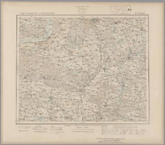
Composite: 276. Rogasen.
1 : 100000 Reichsamt fur Landesaufnahme
251. Wongrowitz.
1 : 100000 Reichsamt fur Landesaufnahme
Composite: 275. Samter.
1 : 100000 Reichsamt fur Landesaufnahme
275. Samter.
1 : 100000 Reichsamt fur Landesaufnahme
Composite: 251. Wongrowitz.
1 : 100000 Reichsamt fur Landesaufnahme
Meßtischblatt 3468 : Murowana-Goslin, 1940
1 : 250000 Murowana-Goslin. - Ausg. m. dt. Namen, letzte Nachtr. 1933, Ausg. m. vorläuf. Namensänd.. - 1:25000. - [Berlin]: Reichsamt für Landesaufnahme, 1940. - 1 Kt.
Meßtischblatt 3467 : Owinsk, 1940
1 : 250000 Owinsk. - Ausg. m. dt. Namen, letzte Nachtr. 1933, Ausg. m. vorläuf. Namensänd.. - 1:25000. - [Berlin]: Reichsamt für Landesaufnahme, 1940. - 1 Kt.
Meßtischblatt 3465 : Kazmierz, 1940
1 : 250000 Kazmierz. - Ausg. m. dt. Namen, letzte Nachtr. 1931, Ausg. m. vorläuf. Namensänd.. - 1:25000. - [Berlin]: Reichsamt für Landesaufnahme, 1940. - 1 Kt.
Meßtischblatt 1857 : Wargowo, 1892
1 : 250000 Wargowo. - Aufn. 1890. - 1:25000. - [Berlin]: Reichsamt für Landesaufnahme, 1892. - 1 Kt.
Meßtischblatt 3368 : Schokken, 1940
1 : 250000 Schokken. - Ausg. m. dt. Namen, letzte Nachtr. 1933. - 1:25000. - [Berlin]: Reichsamt für Landesaufnahme, 1940. - 1 Kt.
Meßtischblatt 3367 : Lukowo, 1940
1 : 250000 Lukowo. - Ausg. m. dt. Namen, letzte Nachtr. 1933. - 1:25000. - [Berlin]: Reichsamt für Landesaufnahme, 1940. - 1 Kt.
Meßtischblatt 3365 : Samter, 1936
1 : 250000 Samter. - Aufn. 1890, letzte Nachtr. 1931/32. - 1:25000. - [Berlin]: Reichsamt für Landesaufnahme, 1936. - 1 Kt.
Meßtischblatt 3366 : Obornik, 1940
1 : 250000 Obornik. - Ausg. m. dt. Namen, letzte Nachtr. 1931. - 1:25000. - [Berlin]: Reichsamt für Landesaufnahme, 1940. - 1 Kt.
Meßtischblatt 3268 : Rogasen, 1936
1 : 250000 Rogasen. - Aufn. 1888, letzte Nachtr. 1933/35. - 1:25000. - [Berlin]: Reichsamt für Landesaufnahme, 1936. - 1 Kt.
Meßtischblatt 3267 : Bülowsthal, 1936
1 : 250000 Bülowsthal. - Aufn. 1888, letzte Nachtr. 1933/35. - 1:25000. - [Berlin]: Reichsamt für Landesaufnahme, 1936. - 1 Kt.
Meßtischblatt 1712 : Obersitzko, 1911
1 : 250000 Obersitzko. - Aufn. 1890, hrsg. 1892, einz. Nachtr. 1911. - 1:25000. - [Berlin]: Reichsamt für Landesaufnahme, 1911. - 1 Kt.
Meßtischblatt 1713 : Polajewo, 1892
1 : 250000 Polajewo. - Aufn. 1890. - 1:25000. - [Berlin]: Reichsamt für Landesaufnahme, 1892. - 1 Kt.
Meßtischblatt 1645 : Zelitz, 1890
1 : 250000 Zelitz. - Aufn. 1888. - 1:25000. - [Berlin]: Reichsamt für Landesaufnahme, 1890. - 1 Kt.
Meßtischblatt 3167 : Budsin, 1936
1 : 250000 Budsin. - Letzte Nachtr. 1934/35. - 1:25000. - [Berlin]: Reichsamt für Landesaufnahme, 1936. - 1 Kt.
Meßtischblatt 3165 : Lubasch, 1934
1 : 250000 Lubasch. - Hrsg. 1892, bericht. 1934. - 1:25000. - [Berlin]: Reichsamt für Landesaufnahme, 1934. - 1 Kt.
Meßtischblatt 3166 : Schrotthaus, 1936
1 : 250000 Schrotthaus. - Aufn. 1890, letzte Nachtr. 1934/35. - 1:25000. - [Berlin]: Reichsamt für Landesaufnahme, 1936. - 1 Kt.
Meßtischblatt 3068 : Margonin, 1940
1 : 250000 Margonin. - Ausg. m. dt. Namen, Ausg. 1940 m. vorläuf. Namen. - 1:25000. - [Berlin]: Reichsamt für Landesaufnahme, 1940. - 1 Kt.
Meßtischblatt 1574 : Margonin, 1889
1 : 250000 Margonin. - Aufn. 1888. - 1:25000. - [Berlin]: Reichsamt für Landesaufnahme, 1889. - 1 Kt.
Meßtischblatt 3067 : Kolmar in Posen, 1940
1 : 250000 Kolmar in Posen. - Ausg. m. dt. Namen, Ausg. 1940 m. vorläuf. Namen. - 1:25000. - [Berlin]: Reichsamt für Landesaufnahme, 1940. - 1 Kt.
Meßtischblatt 1571 : Czarnikau, 1891
1 : 250000 Czarnikau. - Aufn. 1890. - 1:25000. - [Berlin]: Reichsamt für Landesaufnahme, 1891. - 1 Kt.
Meßtischblatt 1572 : Gembitz, 1892
1 : 250000 Gembitz. - Aufn. 1890. - 1:25000. - [Berlin]: Reichsamt für Landesaufnahme, 1892. - 1 Kt.