Maps of Celle

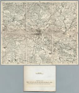
262. Celle.
1 : 100000 Reichsamt fur Landesaufnahme
Composite: 262. Celle.
1 : 100000 Reichsamt fur Landesaufnahme
Meßtischblatt 1746 : Beedenbostel, 1901
1 : 250000 Beedenbostel. - Aufn. 1899. - 1:25000. - [Berlin]: Reichsamt für Landesaufnahme, 1901. - 1 Kt.
Meßtischblatt 1745 : Celle, 1931
1 : 250000 Celle. - Hrsg. 1900, bericht. 1931. - 1:25000. - [Berlin]: Reichsamt für Landesaufnahme, 1931. - 1 Kt.
Meßtischblatt 1744 : Winsen a. d. Aller, 1927
1 : 250000 Winsen a. d. Aller. - Hrsg. 1901, einz. Nachtr. 1927. - 1:25000. - [Berlin]: Reichsamt für Landesaufnahme, 1927. - 1 Kt.
Meßtischblatt 1818 : Bröckel, 1937
1 : 250000 Bröckel. - Hrsg. 1901, einz. Nachtr. 1931, gedr. [19]37. - 1:25000. - [Berlin]: Reichsamt für Landesaufnahme, 1937. - 1 Kt.
Meßtischblatt 1817 : Wathlingen, 1901
1 : 250000 Wathlingen. - Aufn. 1899, hrsg. 1901. - 1:25000. - [Berlin]: Reichsamt für Landesaufnahme, 1901. - 1 Kt.
Meßtischblatt 1816 : Fuhrberg, 1901
1 : 250000 Fuhrberg. - Aufn. 1899. - 1:25000. - [Berlin]: Reichsamt für Landesaufnahme, 1901. - 1 Kt.
Meßtischblatt 1672 : Offen, 1938
1 : 250000 Offen. - Hrsg. 1901, bericht. 1937, einz. Nachtr. 1938. - 1:25000. - [Berlin]: Reichsamt für Landesaufnahme, 1938. - 1 Kt.
Meßtischblatt 1673 : Sülze, 1936
1 : 250000 Sülze. - Hrsg. 1901, einz. Nachtr. 1931, gedr. [19]36. - 1:25000. - [Berlin]: Reichsamt für Landesaufnahme, 1936. - 1 Kt.
Meßtischblatt 1674 : Eschede, 1937
1 : 250000 Eschede. - Hrsg. 1901, einz. Nachtr. 1937. - 1:25000. - [Berlin]: Reichsamt für Landesaufnahme, 1937. - 1 Kt.
Meßtischblatt 1674 : Eschede, 1901
1 : 250000 Eschede. - Aufn. 1899. - 1:25000. - [Berlin]: Reichsamt für Landesaufnahme, 1901. - 1 Kt.
73. Celle, uit: Topographische Uebersichtskarte des Deutschen Reiches / herausgegeben v. d. Kartogr. Abt. d. Königl. Preuß. Landesaufnahme
1 : 200000 titelvariant: Topogr. Übersichtskarte des Deutschen Reiches; Annotatie: Titel boven bladen ook: Topogr. Übersichtskarte des Deutschen Reiches; Annotatie geografische gegevens: Op elk blad twee maatstokken: 10 Kilometer = 5,5 cm; 1 geogr. Meile = 3,6 cm; Legenda onder op elk blad Königlich Preußische Landesaufnahme. Kartographische Abtheilung [S.l : Königlich Preußische Landesaufnahme, Kartographische Abtheilung]
Meßtischblatt 1743 : Thören, 1899
1 : 250000 Thören. - Aufn. 1897. - 1:25000. - [Berlin]: Reichsamt für Landesaufnahme, 1899. - 1 Kt.
Meßtischblatt 1815 : Mellendorf, 1899
1 : 250000 Mellendorf. - Aufn. 1897. - 1:25000. - [Berlin]: Reichsamt für Landesaufnahme, 1899. - 1 Kt.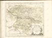

Le Theatre de Bellone :
Mollova mapová sbírka Schenk, Pieter Braakman, Adriaan
Carte topographique d'Allemagne
1 : 214500 Braniborsko (Německo) Jaeger, Johann Wilhelm Abraham Berndt, Johann Christoph I.W.A. Iaeger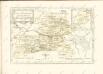

Hannover 58, uit: Special-Karte von Mittel-Europa / nach amtlichen Quellen bearbeitet von W. Liebenow
1 : 300000 titelvariant: W. Liebenow's Mittel-Europa; Annotatie: Titel boven de bladen: W. Liebenow's Mittel-Europa Johannes Wilhelm Liebenow 1822-1897 Frankfurt a. M. : Ludwig Ravenstein
Hannover 58, uit: [W. Liebenow's Special-Karte von Mittel-Europa]
1 : 300000 titelvariant: W. Liebenow's Mittel-Europa; Annotatie: Titel boven de bladen: W. Liebenow's Mittel-Europa Johannes Wilhelm Liebenow 1822-1897 Hannover : Hermann Oppermann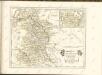

Composite: 237. Soltau.
1 : 100000 Reichsamt fur Landesaufnahme
263. Wittingen.
1 : 100000 Reichsamt fur Landesaufnahme
237. Soltau.
1 : 100000 Reichsamt fur Landesaufnahme
Composite: 263. Wittingen.
1 : 100000 Reichsamt fur Landesaufnahme
236. Walsrode.
1 : 100000 Reichsamt fur Landesaufnahme
261. Neustadt a. Rubenberge.
1 : 100000 Reichsamt fur Landesaufnahme
Meßtischblatt 3224 : Ostenholz, 1942
1 : 250000 Ostenholz. - bericht. 1937, letzte Nachtr. 1940, Ausg. 1942. - 1:25000. - [Berlin]: Reichsamt für Landesaufnahme, 1942. - 1 Kt.