Maps of Heidekreis

Le Theatre de Bellone :
Mollova mapová sbírka Schenk, Pieter Braakman, Adriaan
Lüneburg 45, uit: [W. Liebenow's Special-Karte von Mittel-Europa]
1 : 300000 titelvariant: W. Liebenow's Mittel-Europa; Annotatie: Titel boven de bladen: W. Liebenow's Mittel-Europa Johannes Wilhelm Liebenow 1822-1897 Hannover : Hermann Oppermann
Lüneburg 45, uit: Special-Karte von Mittel-Europa / nach amtlichen Quellen bearbeitet von W. Liebenow
1 : 300000 titelvariant: W. Liebenow's Mittel-Europa; Annotatie: Titel boven de bladen: W. Liebenow's Mittel-Europa Johannes Wilhelm Liebenow 1822-1897 Frankfurt a. M. : Ludwig Ravenstein

73. Celle, uit: Topographische Uebersichtskarte des Deutschen Reiches / herausgegeben v. d. Kartogr. Abt. d. Königl. Preuß. Landesaufnahme
1 : 200000 titelvariant: Topogr. Übersichtskarte des Deutschen Reiches; Annotatie: Titel boven bladen ook: Topogr. Übersichtskarte des Deutschen Reiches; Annotatie geografische gegevens: Op elk blad twee maatstokken: 10 Kilometer = 5,5 cm; 1 geogr. Meile = 3,6 cm; Legenda onder op elk blad Königlich Preußische Landesaufnahme. Kartographische Abtheilung [S.l : Königlich Preußische Landesaufnahme, Kartographische Abtheilung]
57. Harburg, uit: Topographische Uebersichtskarte des Deutschen Reiches / herausgegeben v. d. Kartogr. Abt. d. Königl. Preuß. Landesaufnahme
1 : 200000 titelvariant: Topogr. Übersichtskarte des Deutschen Reiches; Annotatie: Titel boven bladen ook: Topogr. Übersichtskarte des Deutschen Reiches; Annotatie geografische gegevens: Op elk blad twee maatstokken: 10 Kilometer = 5,5 cm; 1 geogr. Meile = 3,6 cm; Legenda onder op elk blad Königlich Preußische Landesaufnahme. Kartographische Abtheilung [S.l : Königlich Preußische Landesaufnahme, Kartographische Abtheilung]
178. Harburg. (Germany)
1 : 100000 Reichsamt fur Landesaufnahme

236. Walsrode.
1 : 100000 Reichsamt fur Landesaufnahme
Composite: 208. Rotenburg i/Hann. (Germany)
1 : 100000 Reichsamt fur Landesaufnahme
Composite: 236. Walsrode.
1 : 100000 Reichsamt fur Landesaufnahme
Composite: 262. Celle.
1 : 100000 Reichsamt fur Landesaufnahme
Composite: 209. Amelinghausen. (Germany)
1 : 100000 Reichsamt fur Landesaufnahme
177. Buxtehude. (Germany)
1 : 100000 Reichsamt fur Landesaufnahme
237. Soltau.
1 : 100000 Reichsamt fur Landesaufnahme
262. Celle.
1 : 100000 Reichsamt fur Landesaufnahme
Composite: 178. Harburg. (Germany)
1 : 100000 Reichsamt fur Landesaufnahme
208. Rotenburg i/Hann. (Germany)
1 : 100000 Reichsamt fur Landesaufnahme
Composite: 237. Soltau.
1 : 100000 Reichsamt fur Landesaufnahme
Composite: 177. Buxtehude. (Germany)
1 : 100000 Reichsamt fur Landesaufnahme
209. Amelinghausen. (Germany)
1 : 100000 Reichsamt fur Landesaufnahme
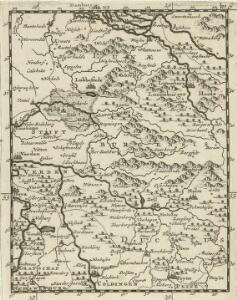
CELEBERRIMI FLVVII | ALBIS | nova delineatio
Auctore Christiano Mollero. Amstelodami, Guilj. Blaeuw Excudit.
261. Neustadt a. Rubenberge.
1 : 100000 Reichsamt fur Landesaufnahme
Composite: 261. Neustadt a. Rubenberge.
1 : 100000 Reichsamt fur Landesaufnahme
Germany 1:25,000, Ostervesede
Germany 1:25,000 , Series GSGS 4414. Great Britain. War Office. [London] : War Office
Germany 1:25,000, Kirchwalsede
Germany 1:25,000 , Series GSGS 4414. Great Britain. War Office. [London] : War Office
Germany 1:25,000, Garlstorf
Germany 1:25,000 , Series GSGS 4414. Great Britain. War Office. [London] : War Office
Germany 1:25,000, Gr. Sittensen
Germany 1:25,000 , Series GSGS 4414. Great Britain. War Office. [London] : War Office