Maps of Oder-Welse

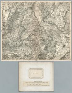
217. Schwedt. (Germany)
1 : 100000 Reichsamt fur Landesaufnahme
Meßtischblatt 1483 : Angermünde, 1932
1 : 250000 Angermünde. - Hrsg. 1889, einz. Nachtr. 1932. - 1:25000. - [Berlin]: Reichsamt für Landesaufnahme, 1932. - 1 Kt.
Meßtischblatt 1482 : Greiffenberg, 1890
1 : 250000 Greiffenberg. - Aufn. 1888. - 1:25000. - [Berlin]: Reichsamt für Landesaufnahme, 1890. - 1 Kt.
Meßtischblatt Passow
1 : 250000 Passow. - Hrsg. 1890, einz. Nachtr. 1912. - 1:25000. - [Berlin]: Reichsamt für Landesaufnahme, 1936. - 1 Kt.
Meßtischblatt 1402 : Polssen, 1906
1 : 250000 Polssen. - Aufn. 1888, hrsg. 1890. - 1:25000. - [Berlin]: Reichsamt für Landesaufnahme, 1906. - 1 Kt.
Meßtischblatt 1484 : Schwedt, 1933
1 : 250000 Schwedt. - Hrsg. 1889, bericht. 1933. - 1:25000. - [Berlin]: Reichsamt für Landesaufnahme, 1933. - 1 Kt.
Meßtischblatt 1484 : Schwedt, 1921
1 : 250000 Schwedt. - Aufn. 1888, Nachtr. 1921. - 1:25000. - [Berlin]: Reichsamt für Landesaufnahme, 1921. - 1 Kt.
Meßtischblatt 2851 : Kunow, 1953
1 : 250000 Kunow. - Hrsg. 1890, letzte Nachtr. 1932, Ausgabe 1937. - 1:25000. - [S.l.]: VDB, 1953. - 1 Kt.
Composite: 217. Schwedt. (Germany)
1 : 100000 Reichsamt fur Landesaufnahme
Meßtischblatt 1321 : Bietikow, 1936
1 : 250000 Bietikow. - Hrsg. 1889, bericht. 1911, einz. Nachtr. 1936. - 1:25000. - [Berlin]: Reichsamt für Landesaufnahme, 1936. - 1 Kt.
Meßtischblatt 1322 : Gramzow, 1888
1 : 250000 Gramzow. - Aufn. 1887. - 1:25000. - [Berlin]: Reichsamt für Landesaufnahme, 1888. - 1 Kt.
Meßtischblatt 2751 : Penkun, 1932
1 : 250000 Penkun. - Hrsg. 1888, bericht. 1911, letzte Nachtr. 1932. - 1:25000. - [Berlin]: Reichsamt für Landesaufnahme, 1932. - 1 Kt.
61. Prenzlau, uit: Topographische Uebersichtskarte des Deutschen Reiches / herausgegeben v. d. Kartogr. Abt. d. Königl. Preuß. Landesaufnahme
1 : 200000 titelvariant: Topogr. Übersichtskarte des Deutschen Reiches; Annotatie: Titel boven bladen ook: Topogr. Übersichtskarte des Deutschen Reiches; Annotatie geografische gegevens: Op elk blad twee maatstokken: 10 Kilometer = 5,5 cm; 1 geogr. Meile = 3,6 cm; Legenda onder op elk blad Königlich Preußische Landesaufnahme. Kartographische Abtheilung [S.l : Königlich Preußische Landesaufnahme, Kartographische Abtheilung]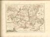
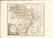
Marchionatus Brandenburgici Partes Duae Nova Marchia et Uckerana
1 : 420000 Mollova mapová sbírka Örnehufvud, Olof Hansson Covens, Johannes I
Küstrin 48, uit: Special-Karte von Mittel-Europa / nach amtlichen Quellen bearbeitet von W. Liebenow
1 : 300000 titelvariant: W. Liebenow's Mittel-Europa; Annotatie: Titel boven de bladen: W. Liebenow's Mittel-Europa Johannes Wilhelm Liebenow 1822-1897 Frankfurt a. M. : Ludwig Ravenstein
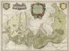
Theatrum belli in Pomerania Citeriori
1 : 140000 Mollova mapová sbírka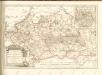

218. Gartz a. d. O. (Germany)
1 : 100000 Reichsamt fur Landesaufnahme
245. Freienwalde.
1 : 100000 Reichsamt fur Landesaufnahme
Meßtischblatt Stolpe
1 : 250000 Stolpe. - Aufn. 1888 u. 1926/27, hrsg. 1889. - 1:25000. - [Berlin]: Reichsamt für Landesaufnahme, 1942. - 1 Kt.
Meßtischblatt 1556 : Stolpe in der Mark, 1912
1 : 250000 Stolpe in der Mark. - Aufn. 1888, hrsg. 1889, einzelne Nachtr. 1912. - 1:25000. - [Berlin]: Reichsamt für Landesaufnahme, 1912. - 1 Kt.
Meßtischblatt 3049 : Gr. Ziethen, 1943
1 : 250000 Gr. Ziethen. - Aufn. 1888, hrsg. 1889, letzte Nachtr. 1942. - 1:25000. - [Berlin]: Reichsamt für Landesaufnahme, 1943. - 1 Kt.
Meßtischblatt Zachow
1 : 250000 Zachow. - Aufn. 1888 (1933), hrsg. 1889, letzte Nachtr. 19. - 1:25000. - [Berlin]: Reichsamt für Landesaufnahme, 1942. - 1 Kt.
[Operationen der alliirten und französischen Armee 1759]

MARCHIONATUS | BRANDENBURGICI | PARTES DUÆ, | NOVA MARCHIA | et | UCKERANA
Auctore | OLAO JOANNIS GOTHO | Gustaui Magni Cosmographo. [Amsterdam : Joan Blaeu]
Sect. 9: Stettin, uit: Geologische Karte des Deutschen Reichs in 27 Blaettern / [von] Richard Lepsius ; Red. von C. Vogel
1 : 500000 Annotatie: Blad 18 ontbreekt; Een aantal bladen op linnen; Een aantal bladen gereviseerd 1913-1914; Annotatie geografische gegevens: Met schaalstokken o.a. in kilometers; Legenda Carl Vogel 1828-1897 Gotha : Justus Perthes
Marchia Media Vulgo Mittel Marck in March: Brandenb:
1 : 500000 Mollova mapová sbírka Valk, Gerhard Schenk, Peter I