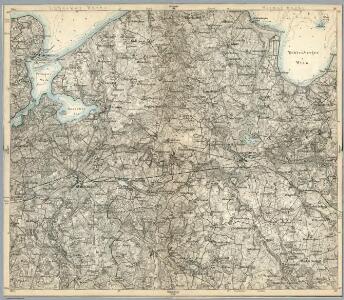
Maps of Grevesmühlen-Land

Composite: 115. Schonberg in Mecklenbg. (Germany)
1 : 100000 Reichsamt fur Landesaufnahme
115. Schonberg in Mecklenbg. (Germany)
1 : 100000 Reichsamt fur Landesaufnahme
Meßtischblatt 2233 : Mühlen- Eichsen, 1924
1 : 250000 Mühlen- Eichsen. - Hrsg. 1879. - 1:25000. - [Berlin]: Reichsamt für Landesaufnahme, 1924. - 1 Kt.
Meßtischblatt 2232 : Gadebusch, 1924
1 : 250000 Gadebusch. - Hrsg. 1881, Ausg. 1924. - 1:25000. - [Berlin]: Reichsamt für Landesaufnahme, 1924. - 1 Kt.
Meßtischblatt 2231 : Carlow, 1919
1 : 250000 Carlow. - Hrsg. 1879, bericht. 1904, letzte Nachtr. 1919. - 1:25000. - [Berlin]: Reichsamt für Landesaufnahme, 1919. - 1 Kt.
Meßtischblatt 2133 : Grevesmühlen, 1940
1 : 250000 Grevesmühlen. - Hrsg. 1879, Ausg. 1919, letzte Nachtr. 1919, red. - 1:25000. - [Berlin]: Reichsamt für Landesaufnahme, 1940. - 1 Kt.
Meßtischblatt 2132 : Mummendorf, 1877
1 : 250000 Mummendorf. - Hrsg. 1877. - 1:25000. - [Berlin]: Reichsamt für Landesaufnahme, 1877. - 1 Kt.
Meßtischblatt 2131 : Schönberg in Mecklenburg, 1906
1 : 250000 Schönberg in Mecklenburg. - Hrsg. 1879, letzte Nachtr. 1906. - 1:25000. - [Berlin]: Reichsamt für Landesaufnahme, 1906. - 1 Kt.
Meßtischblatt 2033 : Hohenkirchen (in Mecklenburg), 1934
1 : 250000 Hohenkirchen (in Mecklenburg). - Hrsg. 1877. - 1:25000. - [Berlin]: Reichsamt für Landesaufnahme, 1934. - 1 Kt.
Meßtischblatt 2032 : Kalkhorst, 1912
1 : 250000 Kalkhorst. - Hrsg. 1879, bericht. 1904, letzte Nachtr. 1912. - 1:25000. - [Berlin]: Reichsamt für Landesaufnahme, 1912. - 1 Kt.
Meßtischblatt 662 : Travemünde, 1879
1 : 250000 Travemünde. - Aufn. 1877. - 1:25000. - [Berlin]: Reichsamt für Landesaufnahme, 1879. - 1 Kt.
Stralsund
Stralsund (Německo)
Stralsund
Stralsund (Německo)
Stralsund
Stralsund (Německo)
Stralsund
Stralsund (Německo)
Meßtischblatt 841, neue Nr. 2230 : Ratzeburg, 1937
1 : 250000 Ratzeburg. - Hrsg. 1881, einz. Nachtr. 1908, gedr. [19]37. - 1:25000. - [Berlin]: Reichsamt für Landesaufnahme, 1937. - 1 Kt.
Meßtischblatt 841 : Ratzeburg, 1908
1 : 250000 Ratzeburg. - Aufn. 1877/79, hrsg. 1881, einzelne Nachtr. 1908. - 1:25000. - [Berlin]: Reichsamt für Landesaufnahme, 1908. - 1 Kt.
Meßtischblatt 2130 : Lübeck, 1941
1 : 250000 Lübeck. - Hrsg. 1879, bericht. 1920. - 1:25000. - [Berlin]: Reichsamt für Landesaufnahme, 1941. - 1 Kt.
Meßtischblatt 747 : Lübeck, 1920
1 : 250000 Lübeck. - Aufn. 1877, bericht. 1920. - 1:25000. - [Berlin]: Reichsamt für Landesaufnahme, 1920. - 1 Kt.
Meßtischblatt 747 : Lübeck, 1914
1 : 250000 Lübeck. - Aufn. 1877, hrsg. 1879, Aufldr. 1914. - 1:25000. - [Berlin]: Reichsamt für Landesaufnahme, 1914. - 1 Kt.
Meßtischblatt 661 : Schwartau, 1900
1 : 250000 Schwartau. - Aufn. 1877, hrsg. 1879, einz. Nachtr. 1900. - 1:25000. - [Berlin]: Reichsamt für Landesaufnahme, 1900. - 1 Kt.
Meßtischblatt 2333 : Gross- Brütz, 1881
1 : 250000 Gross- Brütz. - Aufn. 1879. - 1:25000. - [Berlin]: Reichsamt für Landesaufnahme, 1881. - 1 Kt.
Meßtischblatt 2332 : Gr. Salitz, 1954
1 : 250000 Gr. Salitz. - Hrsg. 1881, bericht. 1952, Ausg. 1954. - 1:25000. - [S.l.]: MdI, 1954. - 1 Kt.
Meßtischblatt 2331 : Seedorf, 1954
1 : 250000 Seedorf. - Hrsg. 1881, letzte Nachtr. 1924. - 1:25000. - [S.l.]: VD Mecklenburg, 1954. - 1 Kt.
Meßtischblatt 938 : Mölln, 1881
1 : 250000 Mölln. - Aufn. 1879. - 1:25000. - [Berlin]: Reichsamt für Landesaufnahme, 1881. - 1 Kt.
41. Lübeck, uit: Topographische Uebersichtskarte des Deutschen Reiches / herausgegeben v. d. Kartogr. Abt. d. Königl. Preuß. Landesaufnahme
1 : 200000 titelvariant: Topogr. Übersichtskarte des Deutschen Reiches; Annotatie: Titel boven bladen ook: Topogr. Übersichtskarte des Deutschen Reiches; Annotatie geografische gegevens: Op elk blad twee maatstokken: 10 Kilometer = 5,5 cm; 1 geogr. Meile = 3,6 cm; Legenda onder op elk blad Königlich Preußische Landesaufnahme. Kartographische Abtheilung [S.l : Königlich Preußische Landesaufnahme, Kartographische Abtheilung]
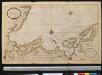
Nieuwe afteekening van een gedeelte van de Belt Zee daer in het in koomen van Wismar en de rivier van Lübeck geleegen aen de kust van Meekelen Burgh
Germany Johannes van Keulen
Ostsee
1 : 50000 Lübeck (Německo : oblast) Reichs-Marine-Amt