Maps of Stepenitztal

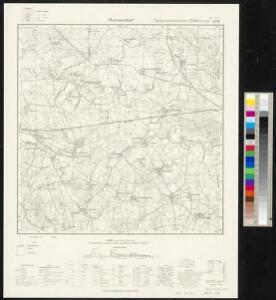
Meßtischblatt 2132 : Mummendorf, 1877
1 : 250000 Mummendorf. - Hrsg. 1877. - 1:25000. - [Berlin]: Reichsamt für Landesaufnahme, 1877. - 1 Kt.
Composite: 115. Schonberg in Mecklenbg. (Germany)
1 : 100000 Reichsamt fur Landesaufnahme
115. Schonberg in Mecklenbg. (Germany)
1 : 100000 Reichsamt fur Landesaufnahme
41. Lübeck, uit: Topographische Uebersichtskarte des Deutschen Reiches / herausgegeben v. d. Kartogr. Abt. d. Königl. Preuß. Landesaufnahme
1 : 200000 titelvariant: Topogr. Übersichtskarte des Deutschen Reiches; Annotatie: Titel boven bladen ook: Topogr. Übersichtskarte des Deutschen Reiches; Annotatie geografische gegevens: Op elk blad twee maatstokken: 10 Kilometer = 5,5 cm; 1 geogr. Meile = 3,6 cm; Legenda onder op elk blad Königlich Preußische Landesaufnahme. Kartographische Abtheilung [S.l : Königlich Preußische Landesaufnahme, Kartographische Abtheilung]
WAGRIA, | que est | PARS ORIENTALIS | HOLSATIÆ.
Matthias & Nicolaus Peters | Goltschmide gebr. Hus. sculpst. [Amsterdam : Joan Blaeu]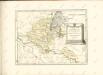

Schwerin 34, uit: Special-Karte von Mittel-Europa / nach amtlichen Quellen bearbeitet von W. Liebenow
1 : 300000 titelvariant: W. Liebenow's Mittel-Europa; Annotatie: Titel boven de bladen: W. Liebenow's Mittel-Europa Johannes Wilhelm Liebenow 1822-1897 Frankfurt a. M. : Ludwig Ravenstein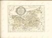

Mappa Ducatus Megalopolitani Nova :
1 : 190000 Mollova mapová sbírka
Wagria, quae est Pars Orientalis Holsatiae. [Karte], in: Novus atlas absolutissimus, Bd. 1, S. 149.
1 Karte aus Atlas Janssonius Offizin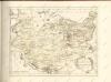

Holsatia ducatus
1 Karte : Kupferdruck ; 33 x 46 cm Mercator; Hondius Henricus Hondius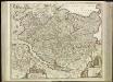
[45][45] Holsatiae tabula generalis ..., uit: Atlas sive Descriptio terrarum orbis
Annotatie: Gedigitaliseerde versie. Amsterdam. Heiloo : Picturae (vervaardiger), 2015. tiff-bestand. Gedigitaliseerd: 07-01-2015; Origineel: Universiteitsbibliotheek Vrije Universiteit (XL.05127.-) ; Netherlands; Titelpagina ontbreekt Wit, Frederik de Amsterdam : Frederick de Wit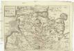
Dvcatvs Holsatiae
Holštýnsko Bouttats, Gaspar
Ducatus Lunenburgensis in omnes ejusdem subjacentes praefecturas Nova descriptio
1 : 870000 Mollova mapová sbírka Danckerts, Justus Danckerts, Justus

HOLSATIAE TABULA GENERALIS in qua sunt DUCATUS HOLSATIAE, DITHMARSIAE STORMARIAE et WAGRIAE
1 : 310000 Holštýnsko Wit, Frederick de Frederic de Wit
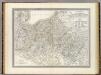
Mecklenburg-Schwerin, Mecklenburg-Strelitz.
1 : 360000 Weiland, C. F. (Carl Ferdinand), d. 1847

Meklenbvrg Dvcatvs
1 : 520000 Mollova mapová sbírka Lauremberg, Johann Schenk, Peter I
Meklenbvrg Dvcatvs
1 : 520000 Mollova mapová sbírka Lauremberg, Johann Janssonius, Johannes I
Meklenbvrg Dvcatvs
1 : 680000 Mollova mapová sbírka Merian, Matthaeus Merian, Matthäus - dědici
Charte von dem Gross-Herzogthümern Mecklenburg-Schwerin, und Mecklenburg-Strelitz
1 : 359000 Meklenbursko (Německo) Streit, Friedrich Wilhelm Friedrich Campe
Ducatus Luneburgici in suas Praefecturas et Vogteyas ad Statum recentissimum divisi Tabula Geographica
1 : 380000 Mollova mapová sbírka Böhme, August Gottlob Homann, Johann Baptista - dědici
Das Hertzogthum Mecklenburg in Nieder Sächßischen Creiße Teutschlandes mit seinen abgetheilten Provintzen
1 : 1300000 Mollova mapová sbírka Weigel, Christoph Weigel, Christoph I.
Mecklenburg.
1 : 595000 Flemming, Carl
Ducatus Meklenburgici Tabula Generalis
1 : 470000 Mollova mapová sbírka Homann, Johann Baptist Homann, Johann Baptista
Ducatus Luneburgicus cum Comitatu Dannebergensi juxta Praefecturas suas accurrate designatus et mappa Geographica
1 : 330000 Mollova mapová sbírka Seutter, Matthäus Seutter, Matthäus
Ducatus Luneburgici et Dannebergensis Comitatus
1 : 330000 Mollova mapová sbírka Wit, Frederik de Covens, Johannes I