Maps of Altiplano

South America 3.
1 : 2800000 Arrowsmith, Aaron
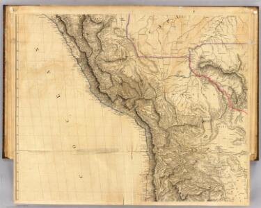
West Coast of South America.
Fullarton, A. & Co.
Een gedeelte van de Zuijdt-Zee van Quilca tot Po. El Guasco geleegen aen de kust van Peru
Chile Gerard van Keulen
Partie du Perou. Amer. Merid. 25.
1 : 1641836 Vandermaelen, Philippe, 1795-1869
West Coast of South America. Peru and Bolivia (mostly Chile) ... Quilca to Cobija.
1 : 1230000 Berghaus, Henry
Carte des Provinces de Salta et de Jujuy et d'une partie de la Bolivie
1 : 2000000 Description géographique et statistique de la Confédération Argentine Martin de Moussy, Victor Librairie de Firmin Didot frères, fils et Cie
La Paz : South America, 1:1,000,000
1 : 1000000
Departamento de Moquegua.
1 : 1080000 Paz Soldan, Mariano Felipe, 1821-1886
Mapa de la Republica de Chile (1)
1 : 11000000 Pissis, Aime, 1812-1889
Departamento de Arequipa.
1 : 1100000 Paz Soldan, Mariano Felipe, 1821-1886
Cote, Perou.
1 : 830000 Lartigue, Joseph, 1791-1876
Corte geologico de la parte sud del Peru.
Paz Soldan, Mariano Felipe, 1821-1886
Mapa del sur del Peru y parte de Bolivia
1 : 1000000 Arequipa : J.L. Villanueva
Carta de la rejion salitrera comprendida entre los paralelos 19° y 27°30' lat. sur
1 : 500000 (Chili) Delegacion fiscal de salitreras Antofagasta : Delegacion fiscal de salitreras
Republica de Chile [17°-19° S]
1 : 500000 (Chili) Oficina de Mensura de Tierras Santiago du Chili : Oficina de Mensura de Tierras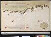
Port de Hillaij, reede van Hierbabouenna en Dierbaboine, de Hoek of Pointe Tambot en Rade deHillot aen de kust van Perou in de Zuijd Zee
Peru Grout Gerard van Keulen
Croquis, ferro-carril entre Arequipa y la costa.
1 : 317500 Paz Soldan, Mariano Felipe, 1821-1886
Provincias de Jujuy y Tucuman.
1 : 1800000 Paz Soldan, Mariano Felipe, 1821-1886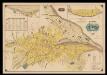
Plano de la ciudad de la Paz
1 : 5000 1 Mapa. Abans 31-5-4 José Rodríguez M. Oficina Cartografica Bemporat
Plano topografico de la region norte argentina limitrofe con Bolivia
1 : 575000 (Argentine) Comision Argentina Demarcadora de Limites con Bolivia [Buenos Aires] :
Central Andes. Pergamon World Atlas.
1 : 5000000 Polish Army Topography Service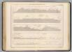
Coupe de la route de Buenos-Ayres a Lima.
1 : 1949000 Martin de Moussy, V. (Victor), 1810-1869
Richard Mayer's commercial map of Northern Chili, Bolivia, & southern Peru
1 : 1000000
Peru.
1 : 11000000 Arrowsmith, Aaron; Lewis, Samuel
Peru

Peru.
1 : 11088000 Lucas, Fielding Jr.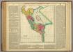
Map Of Peru.
1 : 6336000 Lea, I.
Mapa de Bolivia / tomado de la Carta general y compilación de datos hecha por el ingeniero auxiliar de Obras Públicas Javier Valdez Reinoso
1 : 2400000 1 Mapa, col. Valdez Reinoso, Javier Arnó Hermanos , Hernich y Ca. (Barcelona)
Ober-Paraguarien nebst denen Ländern Baures, Tschikiten, Schareyes, Payaguas, Toromonas, Moschos, Ytonamas, etc., samt einem Theil dern Königreichen Tschili und Peru etc. etc
1 : 6680000 Chile Dietell, Christoph Chri. Dietell