Maps of Puno

Mapa del sur del Peru y parte de Bolivia
1 : 1000000 Arequipa : J.L. Villanueva
Puno - Rio Beni : South America, 1:1,000,000
1 : 1000000
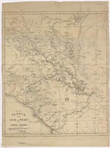
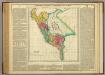
Departamento de Puno.
1 : 1090000 Paz Soldan, Mariano Felipe, 1821-1886
Corte geologico de la parte sud del Peru.
Paz Soldan, Mariano Felipe, 1821-1886
Port de Hillaij, reede van Hierbabouenna en Dierbaboine, de Hoek of Pointe Tambot en Rade deHillot aen de kust van Perou in de Zuijd Zee
Peru Grout Gerard van Keulen
Republica de Chile [17°-19° S]
1 : 500000 (Chili) Oficina de Mensura de Tierras Santiago du Chili : Oficina de Mensura de Tierras
Cote, Perou.
1 : 830000 Lartigue, Joseph, 1791-1876
Plano de la ciudad de la Paz
1 : 5000 1 Mapa. Abans 31-5-4 José Rodríguez M. Oficina Cartografica Bemporat
Partie du Perou. Amer. Merid. 20.
1 : 1641836 Vandermaelen, Philippe, 1795-1869
La Paz : South America, 1:1,000,000
1 : 1000000
Departamento de Cuzco.
1 : 1090000 Paz Soldan, Mariano Felipe, 1821-1886
West Coast of South America. Peru and Bolivia (mostly Chile) ... Quilca to Cobija.
1 : 1230000 Berghaus, Henry
Departamento de Moquegua.
1 : 1080000 Paz Soldan, Mariano Felipe, 1821-1886
Partie du Perou. Amer. Merid. 21.
1 : 1641836 Vandermaelen, Philippe, 1795-1869
Departamento de Arequipa.
1 : 1100000 Paz Soldan, Mariano Felipe, 1821-1886
Croquis, ferro-carril entre Arequipa y la costa.
1 : 317500 Paz Soldan, Mariano Felipe, 1821-1886
Richard Mayer's commercial map of Northern Chili, Bolivia, & southern Peru
1 : 1000000
Mapa del Perú
1 : 4000000 Peru Pesce, Luis Carlos Fabbri
Mapa del Peru
1 : 5000000 Raimondi, Antonio 1826-1890 Paris : Erhard Frères
Mittel- und Nord-Peru und Ekuador
1 : 3000000 Ekvádor Pape, Eduard Tessmann, Günter Friederichsen, De Gruyter & Co.
Charte der Provinz oder Audiencia von Lima oder des alten Königreichs Peru
Map Of Peru.
1 : 6336000 Lea, I.
Central Andes. Pergamon World Atlas.
1 : 5000000 Polish Army Topography Service
Mapa de Bolivia / tomado de la Carta general y compilación de datos hecha por el ingeniero auxiliar de Obras Públicas Javier Valdez Reinoso
1 : 2400000 1 Mapa, col. Valdez Reinoso, Javier Arnó Hermanos , Hernich y Ca. (Barcelona)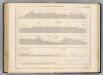
Coupe de la route de Buenos-Ayres a Lima.
1 : 1949000 Martin de Moussy, V. (Victor), 1810-1869
Geographisch-statistische und historische Charte von Peru
1 : 3500000 gezeichnet von Finlayson Weimar : Verlag des Geographischen Instituts
Peru.
1 : 11088000 Lucas, Fielding Jr.
Carta jeogràfica del desierto i cordilleras de Atacama
1 : 1000000 Chile. Dirección General de Obras Públicas. Seccion de Jeografia y Minas Dirección General de Obras Públicas. Seccion de Jeografia y Minas
Peru
1 : 6530000 Peru Finlayson im Verlage des Geographischen Instituts