Maps of Granville
127 St.-Malo, Granville.
1 : 86400 Cassini family; Cassini, Cesar-Francois, 1714-1784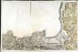
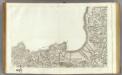
[Saint-Malo - Granville]
1 Blatt : 61 x 92 cm s.n.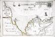
Capitaineries garde costes de Regneville Granville et de Genetz
1 Karte : 22 x 33 cm de Fer
Nieuwe afteekening van het inkoomen en reede van St. Malo naer de laeste Frane afteekeningh
France Johannes van Keulen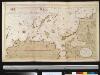
De haven van St. Malo ent incoomen vande rivier Dinan int Canaal aen de kust van Bretagne
France Gerard van Keulen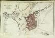
Plan de St. Malo
1 Plan : Kupferdruck ; 31 x 48 cm Le Rouge chez le Rouge rue des Augustins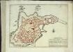
St. Malo
1 Plan : Kupferdruck ; 21 x 29 cm Fer s.n.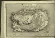
Plan du Mont St. Michel
1 Plan : Kupferdruck ; 22 x 32 cm Fer Guillaume Danet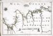
[Partie de la côte de la Bretagne]
1 Karte : 22 x 33 cm de Fer
Jersey, Guernsey.
1 : 364000 Faden, William, 1750?-1836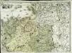
Carte géométrique de la province de Bretagne, 3
1 Blatt : chés l'auteur
Carte reduite des isles de Jersey, Grenesey et d'Aurigny
1 Karte : Kupferdruck ; 54 x 40 cm Bellin s.n.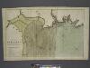
The coast of BRETAGNE from GRANVILLE to CAPEFREHEL
from The sea-atlas : containing an hydrographical description of most of the sea-coasts of the known parts of the world.
Carte générale, des isles Grenesey, Jersey, Aurigny, Chausey, &c
1 Karte : Kupferdruck ; 50 x 43 cm Beaurain chez le chevalier de Beaurain rue Git-le cœur la 1.ere porte en entrant par le quai des Augustins
Northwestern Normandy : natural regions
1 : 550000 Provisional ed. Relief shown by shading. "Map no. 2369, 8 July 1943." "Restricted." "Reliability code: 00--2B--2." United States. Office of Strategic Services. Research and Analysis Branch [Washington, D.C.] : R & A, OSS
Département de la Manche
1 Karte : Kupferdruck ; 41 x 34 cm Capitaine s.n.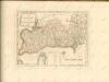

Département de l'Isle et Vilaine
1 Karte : Kupferdruck ; 41 x 35 cm Capitaine s.n.
Département de la Manche
1 Karte : Kupferdruck ; 60 x 40 cm au bureau de l'atlas national rue de la Harpe n.o 26, et au dépost de cet atlas rue de la Monnoie n.o 5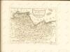


France 1:250,000, Caen
Sheet 8 of the 40-sheet map series, France 1:250 000, Series GSGS 2738. Great Britain. General Staff. Geographical Section. [London] : [GSGS, War Office]
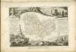
Dept. De La Manche.
1 : 455000 Levasseur, Victor.
Le gouvernement general de Normandie, 1
1 Blatt : chez l'auteur Jaillot
Carte de la province de Normandie, 1
1 Blatt : Esnauts et Rapilly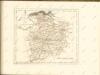

Diocese de Coutances, [feuille 1 et 3]
2 Blätter : Dezauche


