Maps of Atlas Mountains

West and east parts of Barbary.
1 : 11000000 Moll, Herman, d. 1732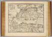
Parts of Barbary.
1 : 7700000 Bowen, Emanuel

North Africa or Barbary : Marocco
1 : 2800000 Society for the Diffusion of Useful Knowledge (Great Britain) George Cox
North Africa or Barbary : Tripoli
1 : 2000000 Society for the Diffusion of Useful Knowledge (Great Britain) George Cox
North Africa or Barbary : Algier
1 : 2000000 Society for the Diffusion of Useful Knowledge (Great Britain) George Cox
North Africa or Barbary : Parts of Tripoli and Egypt
1 : 2000000 Society for the Diffusion of Useful Knowledge (Great Britain) George Cox
North Africa or Barbary : Tunis and part of Tripoli
1 : 2000000 Society for the Diffusion of Useful Knowledge (Great Britain) George Cox
BARBARIA.
[Amsterdam : Joan Blaeu]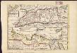
The west part of Barbary containing Fez, Marocco, Algiers and Tunis ; East part of Barbary containing Tripoli, Barca and the north part of Egypt
1 : 11000000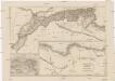
Mauritania, Africa propria, Cyrenaica
1 : 330000 Afrika severní Reichard, Christian Gottlieb Campius, D. a D. Campio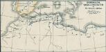
Osmanische Vasallenstaaten in Nordwest-Afrika
1 : 27000000 Osmanisches Reich, Maghreb , Protektorat
Mittelländisches Meer
1 : 8250000 Středozemní moře-oblast Elfert, P. Geogr. Anstalt von Wagner & Debes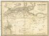
Berberei enthält das Reich Fez und Marocco, Algier, Tunis u. Tripoli
1 : 4500000 Afrika severní Biller, B. Tranquillo Mollo
La Barbarie.
1 : 6500000 Lapie, M. (Pierre), 1779-1850
Aphricae Tabula II. [Karte], in: Claud. Ptolemaeus. Geographia lat. cum mappis [...], S. 287.
1 Karte aus Atlas Münster, Sebastian [und Ptolemaeus, Claudius]
Libyae, vel Africae pars borealis.
1 : 25000000 Fenner, Rest.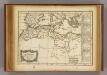
Barbarie.
1 : 17200000 Delamarche, Charles Francois; Lattre, Jean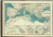
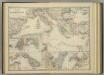
Mediterranean Basin.
1 : 6800000 Johnston, W. & A.K.
Karte des Mittelländischen Meeres
Středozemní moře-oblast Handtke, Friedrich C. Flemming
Libyae vel Africae.
1 : 8200000 Playfair, Principal
Carte d'Europe ou sont tracées les limites des empires, royaumes, et etats souverains, feuille 5
1 Blatt : 56 x 87 cm Semen etc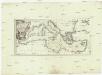
Karte des Mittellaendischen Meers
Středozemní moře-oblast Bonne, Rigobert Schraembl, Franz Anton F.A. Schraembl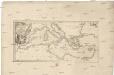
Karte des Mittellaendischen Meers
Středozemní moře-oblast Bonne, Rigobert Schraembl, Franz Anton F.A. Schraembl
Tabula Prima Africae. [Karte], in: Claudii Ptolemei viri Alexandrini mathematice discipline philosophi doctissimi geographie opus [...], S. 181.
1 Karte aus Atlas Waldseemüller, Martin [und Ptolemaeus, Claudius] Übelin, Georg
Etats du roi de Maroc, les royaumes d'Alger, de Tunis et de Tripoli, avec les pays circonvoisins
1 : 9600000 Alžírsko Bonne, Rigobert André
Mediterranean Sea.
1 : 8236800 Stanford, Edward
Africa Northern.
1 : 6400000 Hall, S. (Sidney)
Africae tabula geographica.
1 : 5700000 L'Isle, Guillaume de, 1675-1726