Maps of Annobón
L'Afrique 3.
1 : 10000000 Brue, Adrien Hubert, 1786-1832
Pascaart van de zee-custen van Angola, en Cimbebas van Rivier de Galion tot C. de Bona Esperanca
1 Karte : Kupferdruck ; 42 x 54 cm Doncker by Hendrick Doncker boeckverkoper inde Nieuwebrug-steeg in 't Stuiermans gereetschap
St. Helena, this island belongs to ye English east India Company whose ships usually touch here for a recruit of fresh water and provisions ... ; The bay of Agao de Saldanha, this bay is 70 miles north of ye Cape of Good Hope ...
1 : 1
Arquipélago de S. Tomé e Príncipe Ilha de S. Tomé
1 : 80000 Hydrographic Map Instituto Hidrográfico Portugal Instituto Hidrográfico Portugal
Africa ocidental
1 : 100000 Svatý Tomáš a Princův ostrov Ministerio das Colonias, Comissao de Cartografia
Carta de S. Tomé
1 : 25000 Topographic Map Junta de Investigações do Ultramar Ministério das Colónias
A new mapp of the Island of SAINT HELLENA
from The sea-atlas : containing an hydrographical description of most of the sea-coasts of the known parts of the world.
Arquipélago de S. Tomé e Príncipe ilha de S. Tomé Ilhéu Santana à Ribeira Afonso
1 : 12500 Hydrographic Map Instituto Hidrográfico Portugal Instituto Hidrográfico Portugal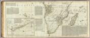
(Africa, with all its states, kingdoms, republics, regions, islands, &ca. Southern section)
1 : 8400000 Boulton, S.
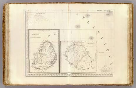
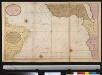
Particular draughts of some of the chief African Islands in the Mediterranean, as also in the Atlantic and Ethiopic Oceans
1 : 1
Africa.
1 : 21542400 Fullarton, A. & Co.
CARTE DE L'OCEAN MERIDIONAL
1 : 6700000 Atlantský oceán-oblast Bellin, Jacques-Nicolas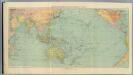
6-8. Linee di comunicazione, oceano Indiano, Pacifico.
1 : 30000000 Touring club italiano
L'Ocean, Fernand de Noronha.
1 : 14800000 Compagnie des Indes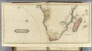
Africa (S sheets)
1 : 11200000 Lizars, Daniel
Carte de la partie de l'ocean vers l'equateur entre les cotes d'Afrique et d'Amerique où la situation des isles, bancs, et vigies
2 Karten auf einem Blatt : Kupferdruck ; Bildgrösse 48 x 64 cm Buache Philippe Buache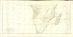
De zeekusten van Gunea van C. Verde tot Cabo de Bona Esperanco als mede de kusten van Brasil op wassende grade
Atlantic Ocean Gerard van Keulen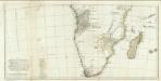
Afrique sud.
1 : 8300000 Anville, Jean Baptiste Bourguignon d, 1697-1782
Carte Generale de L'Afrique Meridionale.
1 : 18500000 Vivien de St Martin, L.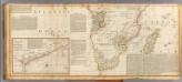
(Africa south)
1 : 8300000 Boulton, S.; Kitchin, Thomas; Robert Laurie & James Whittle
Paskaart van Gvinea van C. Verde tot R. de Galion
1 Karte : Kupferdruck ; 43 x 53 cm Doncker bÿ Hendrick Doncker in de Nieuwebrugsteeg
Senegambien, Sudan, Guinea.
1 : 14700000 Berghaus, Heinrich; Flemming, Carl; Sohr, Karl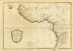
Composite: La Guinee.
1 : 9000000 Bonne, Rigobert, 1727-1794
Cimbebas et Caffariæ littora a Catenbela ad promontorium Bonæ Spei
1 Karte : Kupferdruck ; 41 x 53 cm Renard by L. Renard
[137][140] Cimbebas et Caffariae Littora a Catenbela ad promontorium Bonae Spei ..., uit: Atlas sive Descriptio terrarum orbis
Annotatie: Gedigitaliseerde versie. Amsterdam. Heiloo : Picturae (vervaardiger), 2015. tiff-bestand. Gedigitaliseerd: 07-01-2015; Origineel: Universiteitsbibliotheek Vrije Universiteit (XL.05127.-) ; Netherlands; Titelpagina ontbreekt Wit, Frederik de Amsterdam : Frederick de Wit
Nigritarum Regnum. [Karte], in: Novus atlas absolutissimus, Bd. 6, S. 171.
1 Karte aus Atlas Janssonius Offizin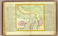
Guinee, Congo.
1 : 15000000 Clouet, J. B. L. (Jean-Baptiste Louis), b. 1730
Untitled