Maps of Sahel

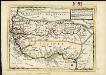
Nigritarum Regnum. [Karte], in: Novus atlas absolutissimus, Bd. 6, S. 171.
1 Karte aus Atlas Janssonius Offizin
Nigritarum regio
1 : 20000000 [S.l. : s.n.]
NIGRITARVM | REGIO.
Amstelædami Ioannes Blaeu Excud.
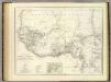
Marocco, Algeria & Tunis. Central Africa.
1 : 4552426 Johnston, W. & A.K.
Übersicht der neuern Erforschungen in Mittel-Africa
Hand-Atlas über alle Theile der Erde nach dem neuesten Zustande und über das Weltgebäude Stieler, Adolf bei Justus Perthes
Senegambien, Sudan, Guinea.
1 : 14700000 Berghaus, Heinrich; Flemming, Carl; Sohr, Karl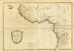
Composite: La Guinee.
1 : 9000000 Bonne, Rigobert, 1727-1794
Particular draughts of some of the chief African Islands in the Mediterranean, as also in the Atlantic and Ethiopic Oceans
1 : 1
[Mittel- und Nord-Africa und Arabien, Westliches Blatt]
Hand-Atlas über alle Theile der Erde nach dem neuesten Zustande und über das Weltgebäude Stieler, Adolf bei Justus Perthes

Nord Africa.
1 : 24000000 Reichard, C. G.
Carte d'une Partie de L'Afrique Septentrionale.
1 : 18500000 Vivien de St Martin, L.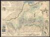
Abissinorum Sive Pretiosi Ioanis Imperium. [Karte] Congi Regni in Africa Christiani Nova descriptio. [Nebenkarte], in: Gerardi Mercatoris Atlas, sive, Cosmographicae meditationes de fabrica mundi et fabricati figura, S. 505.
1 Karte aus Atlas Mercator, Gerhard Montanus, Petrus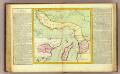
Guinee, Congo.
1 : 15000000 Clouet, J. B. L. (Jean-Baptiste Louis), b. 1730
[136][139] Tractus Littorales Guineae ..., uit: Atlas sive Descriptio terrarum orbis
Annotatie: Gedigitaliseerde versie. Amsterdam. Heiloo : Picturae (vervaardiger), 2015. tiff-bestand. Gedigitaliseerd: 07-01-2015; Origineel: Universiteitsbibliotheek Vrije Universiteit (XL.05127.-) ; Netherlands; Titelpagina ontbreekt Wit, Frederik de Amsterdam : Frederick de Wit
Afrique Occidentale
Vidal de La Blache, Paul
Afrique occidentale et centrale.
1 : 9500000 Garnier, F. A., 1803-1863
Paskaart van Gvinea van C. Verde tot R. de Galion
1 Karte : Kupferdruck ; 43 x 53 cm Doncker bÿ Hendrick Doncker in de Nieuwebrugsteeg
[Afrika, Blatt 3]
Adolf Stieler's Handatlas über alle Theile der Erde und über das Weltgebäude Stieler, Adolf Justus Perthes
Tractus littorales Guineæ a Promontorio Verde usque ad sinum Catenbelæ
1 Karte : Kupferdruck ; 49 x 55 cm Renard apud L. Renard
Africa Southern.
1 : 8000000 Hall, S. (Sidney)
Untitled
West. Mittel-Africa.
1 : 6000000 Weiland, C. F. (Carl Ferdinand), d. 1847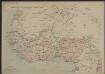
Afrique occidentale française
1 : 8000000
Senegambien
Negroland and Guinea, with the European settlements explaining what belongs to England, Holland, Denmark &c.
1 : 12500000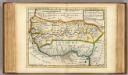
Negroland and Guinea.
1 : 15000000 Moll, Herman, d. 1732
Stanley in Africa
1 : 9500000 Ravenstein, E.G. Georg Philip & Son
![Nigritarum Regnum. [Karte], in: Novus atlas absolutissimus, Bd. 6, S. 171.](https://images-2.georeferencer.com/images/iiif/563615316584/full/,300/0/native.jpg)

