Maps of North Atlantic Ocean
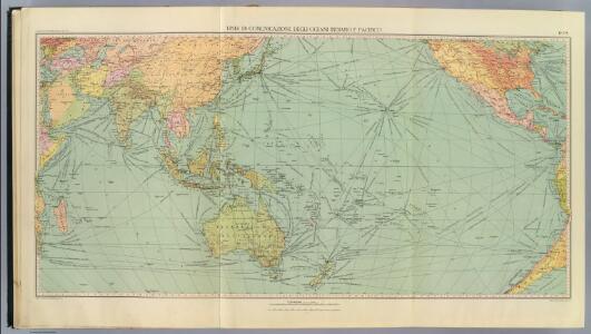
6-8. Linee di comunicazione, oceano Indiano, Pacifico.
1 : 30000000 Touring club italiano
A draught of the coast of AFRICA from the streights mouth to cape bona Esprance
from The sea-atlas : containing an hydrographical description of most of the sea-coasts of the known parts of the world.
Africa.
1 : 21542400 Fullarton, A. & Co.
Particular draughts of some of the chief African Islands in the Mediterranean, as also in the Atlantic and Ethiopic Oceans
1 : 1
Africa.
1 : 30000000 Jefferys, Thomas
Africa (blank)
1 : 30000000 Jefferys, Thomas
L'Ocean, Fernand de Noronha.
1 : 14800000 Compagnie des Indes
Carte de la partie de l'ocean vers l'equateur entre les cotes d'Afrique et d'Amerique où la situation des isles, bancs, et vigies
2 Karten auf einem Blatt : Kupferdruck ; Bildgrösse 48 x 64 cm Buache Philippe Buache
Mittel- und Nord-Africa, westl. Theil

North Western {LF}{LF}Africa
1 : 15000000 Colton, G.W.
Noroeste de Africa
1 mapa. Datat al s. XIX. Gras y compañia, editores. Madrid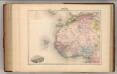
Afrique (Partie Nord-Ouest).
1 : 14400000 Migeon, J.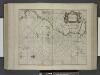
De cust van Barbaria, Gualata, Arguyn, en Geneheo, van Capo Verde.
from De zee-atlas ofte water-wereld : waer in vertoont werden alle de zee-kusten van het bekende des aerd-bodems : seer dienstigh voor alle heeren en kooplieden, als oock voor alle schippers en stuurlieden / by Pieter Goos.
West Africa.
1 : 15000000 Colton, G.W.
North Western Africa.
1 : 15000000 Colton, G.W.
Untitled

Mittel- und Nord-Africa und Arabien. Westliches Blatt
Stieler's Hand-Atlas Stieler, Adolf bei Justus Perthes
Conjecturale de l'Atlantide.
1 : 11000000 Vincent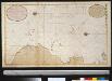
Wassende graade kaart van de Spaanse Zee van het Canaal tot voorbij de Vlaemse Eijlanden
Atlantic Ocean Gerard van Keulen
Portugal.
From [Series of advertising cards issued by Arbuckle Bros. Coffee Company, each consisting of a map of a country of the world with related illustrations.]
West Africa.
1 : 15000000 Colton, G.W.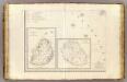
L'Afrique 3.
1 : 10000000 Brue, Adrien Hubert, 1786-1832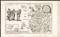
Archipelagus atlanticus cum suis insulis Canariis, Hesperidibus et Azoribus
1 : 1
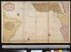
De zeekusten van Gunea van C. Verde tot Cabo de Bona Esperanco als mede de kusten van Brasil op wassende grade
Atlantic Ocean Gerard van Keulen
Itinéraires suivis par les voyages Français et autres qui ont pénétré dans le Sahara
1 : 20000000 Erhard Bros. (Firm) Imp-Janson
Senegambien, Sudan, Guinea.
1 : 14700000 Berghaus, Heinrich; Flemming, Carl; Sohr, Karl
Mittel-& Nord-Afrika, Westl. Theil.
1 : 14000000 Stulpnagel, F.v.
Paskaart van Gvinea van C. Verde tot R. de Galion
1 Karte : Kupferdruck ; 43 x 53 cm Doncker bÿ Hendrick Doncker in de Nieuwebrugsteeg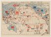
太平洋攻防戰略圖.
Supplement of 科學の日本, 第1卷, 第3號, 新年號." On verso: 世界五大海軍代表艦型一覽圖