Maps of Central Lowland
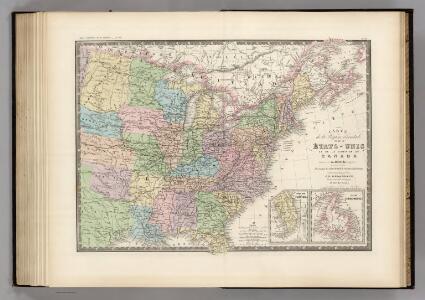
Region Orientale des Etats-Unis, Canada.
1 : 7000000 Levasseur, E.
Etats Unis et Canada.
1 : 8400000 Montemont, A.
Nouvelle carte des États-Unis, du Haut et Bas-Canada, de la Nouvelle-Écosse, du Nouvau-Brunswick, de Terre-Neuve, etc.
1 : 4000000 dressée par A. H. Brué, géographe du Roi Paris : chez l'auteur
Die Neuenglandstaaten bis 1783
1 : 16000000 Berlin : Mittler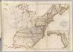
Map of the United States.
1 : 3660000 Carey, Mathew
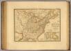
Map of the United States.
1 : 3675000 Carey, Mathew
Vereinigte Staaten von Nord Amerika, ohne das West Gebiet der Union
Etats-Unis, Haut et Bas-Canada, Nouvle. Ecosse, Nouvau. Brunswick, Terre-Neuve.
1 : 7000000 Picquet, C.
Die vereinigten Staaten von Nord-America: nach der von Wm. Faden 1783 herausgegebenen Charte, auf welcher alle im englisch americanischen Kriege vorzüglich merkwürdig gewordenen Örter angezeigt, auch die Grenzen zwischen Grosbrittanien, America und Spanien nach Maasgabe des Friedensschulusses von 1783 bestimmt sind / T. Marianus, Sculp., A.V.; Geschichte der Revolution von Nord-America.
from Geschichte der Revolution von Nord-America. Gegel, Ludwig Bernhard Friederich; Sprengel, M. C. (Matthias Christian),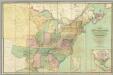
Map of the United States.
1 : 2000000 Walker, John & Alexander
U.S., Canada.
1 : 15600000 Huntington, Nathaniel G. (Nathaniel Gilbert), 1785-1848
United States.
1 : 9200000 Greenleaf, Jeremiah
United States.
1 : 9250000 Greenleaf, Jeremiah
U.S.A. (outline)
1 : 11800000 Patteson, Edward
U.S.A.
1 : 11800000 Patteson, Edward
Map Of The United States Of North America.
1 : 2154240 Vance, David H.
New Map of the United States. (Proposal to publish.)
Vance, David H.
Die Vereinigten Staaten von Nord-Amerika
Allgemeiner Atlas [Walch, Johannes] im Verlag bei Johannes Walch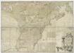
A map of the British and French dominions in North America, with the roads, distances, limits, and extent of the settlements, humbly inscribed to the Right Honourable the Earl of Halifax, and the other Right Honourable the Lords Commissioners for Trade & Plantations / by their Lordships most obliged and very humble servant, Jno. Mitchell; Tho. Kitchin, sculp.
from Parts John Mitchell; Thomas Kitchin,
Mitchell's map of the United States : showing the principal travelling turnpike and common roads, on which are given the distances in miles from one place to another, also the courses of the canals & rail roads throughout the country, carefully compi
from Whole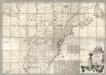
Map of the British and French Dominions in North America.
1 : 2000000 Mitchell, John
Etats-Unis de l'Amerique en 1855.
1 : 8300000 Garnier, F. A., 1803-1863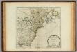
North America from the French of Mr. D'Anville.
1 : 6350000 Jefferys, Thomas
An accurate map of the English colonies in North America bordering on the River Ohio.
from Parts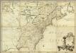
Amerique Septentrionale.
1 : 2000000 Mitchell, John
A New & accurate map of North America: including the British acquisitions gain'd by the late war, 1763.
from Parts [Printed fr Edward and Charles Dilly, in the Poultry, and John Millan, at Charing-Cross]: [London],
Übersichtskarte über die Endmoräne der zweiten Glacialepoche Nord Amerikas nach T. C. Chamberlin 1882
1 : 15000000 gez. v. E. Geinitz aut. v. C. Schmidt Gotha : Perthes
Vereinigte Staaten in Nord America: nach den besten Hülfsmittel verfast / Wien bey T. Mollo.; Lorenz Rieder sc.
from Charts and maps Wien bey; T. Mollo. Lorenz Rieder,
Carte generale des treize Etats Unis, de l'Amerique septentrionale