Maps of United States
Map of the United States.
1 : 2000000 Walker, John & Alexander
Map of the United States.
1 : 3660000 Carey, Mathew
Map of the United States.
1 : 3675000 Carey, Mathew
United States.
1 : 9200000 Greenleaf, Jeremiah
United States.
1 : 9250000 Greenleaf, Jeremiah
The United States of America, showing the boundaries fixed in 1782, five years before the ratification of the Constitution : from a contemporary copy of Benjamin Franklin's red-line map identified in Spain by the Library of Congress at Washington.
1 : 6860480 Facsimile of map published in Paris by Le Rouge and dated 1777. Relief shown pictorially. Inset letters of Aranda and Franklin printed in facsimile reflect the official use of the map in establishing United States boundaries. "Reprinted 1838 by U.S. Geological Survey." Includes text and inset: Nouvelle carte de la Baye dHudson et de Labrador selon las dernieres cartes levées sur les lieux. "This map is one of a series of similar colored maps, depicting the 13 original states from New Hampshire to Georgia at the time of the formation of the Constitution." John, Mitchel, 1711-1768 Washington, D.C. : United States Constitution Sesquicentennial Commission, [Washington, D.C.] : U.S. Geological Survey
A map of the United States : compiled chiefly from the state maps and other authentic information / by Saml. Lewis, 1809 ; W. [Harrison?] Junr., sculpt.
from Carey's American atlas.
Vereinigte Staaten in Nord America: nach den besten Hülfsmittel verfast / Wien bey T. Mollo.; Lorenz Rieder sc.
from Charts and maps Wien bey; T. Mollo. Lorenz Rieder,
Etats-Unis d'Amerique.
1 : 8000000 Andriveau-Goujon, J.
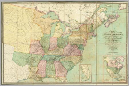
Mitchell's map of the United States : showing the principal travelling turnpike and common roads, on which are given the distances in miles from one place to another, also the courses of the canals & rail roads throughout the country, carefully compi
from Whole
A Map of Carolana and of the River Meschacebe &c.
from Charts and maps Printed for B. Cowse?: [London],
Map Of The United States Of North America.
1 : 2154240 Vance, David H.
New Map of the United States. (Proposal to publish.)
Vance, David H.
Vereinigte Staaten von Nord Amerika, ohne das West Gebiet der Union

The United States of North America, with the British & Spanish territories according to the treaty / engrav'd by Wm. Faden.
from Whole William Faden,
United States
A new general atlas of modern geography, consisting of a complete collection of maps of the four quarters of the globe Wyld, James James Wyld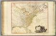
United States of North America.
1 : 6350000 Faden, William, 1750?-1836
U.S. Eastern.
1 : 8870400 Letts, Son & Co.
The United States of America / B. Tanner, sculpt.
from The American war, from 1775 to 1783, with plans / by Charles Smith.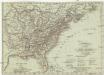
Vereinigte Staaten in Nord America
1 : 10000000 Spojené státy americké-oblast jihovýchodní T. Mollo
The United States of North America, with the British & Spanish territories according to the Treaty of 1784 / engrav'd by Wm. Faden, 1785.
from Charts and maps William Faden,
Die Vereinigten Staaten von Nord-Amerika
Allgemeiner Atlas [Walch, Johannes] im Verlag bei Johannes Walch
Ètats-Unis de l'Amérique septentrionale avec les Isles Royale, de Terre Neuve, de St. Jean, l'Acadie &c.
from Charts and maps Chez Delamarche, géogr.: Paris; Delamarche, Charles François,
Ètats-Unis de l'Amérique septentrionale avec les Isles Royale, de Terre Neuve, de St. Jean, l'Acadie &c.
from John H. Levine Collection Chez Delamarche, géogr.: Paris; Delamarche, Charles François,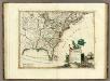
Canada, Le Colonie Inglesi Con La Luigiana, e Florida.
1 : 10000000 Zatta, Antonio
Map Of The United States
1 : 2300000 Vance, David H.
Die Neuenglandstaaten bis 1783
1 : 16000000 Berlin : Mittler
Nouvelle carte des États-Unis, du Haut et Bas-Canada, de la Nouvelle-Écosse, du Nouvau-Brunswick, de Terre-Neuve, etc.
1 : 4000000 dressée par A. H. Brué, géographe du Roi Paris : chez l'auteur
Possessions Francoises.
1 : 12500000 Clouet, J. B. L. (Jean-Baptiste Louis), b. 1730