Maps of Metropolitan France

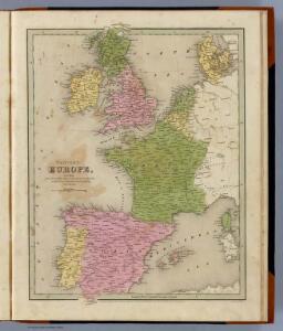
Western Europe.
1 : 6900000 Goodrich, S.G.
Carte des costes maritimes de l'Europe
1 Karte : Kupferdruck ; 64 x 48 cm Nolin; Basset; Basset chez Basset rue St. Jacques
Carte des costes maritimes de l'Europe
1 Karte : Kupferdruck ; 64 x 48 cm Nolin; Daumont chez Daumont rue de la Feronnerie
Orbis Romani pars occidentalis, auspiciis serenissimi principis Ludovici Philippi Aurelianorum ducis publici juris facta
1 : 4300000
L'ocean pres d'Europe
1 Karte : Kupferdruck ; 46 x 34 cm Duval chez l'auteur
England, Scotland & Ireland, with the iles thereto belonging.
from A new systeme of the mathematicks: containing I. Arithmetick, as well natural and decimal, as in species, or the principles of algebra. II. Practical geometry, together with the first six books of Euclid's Elements, as also the eleventh and twelfth, symbo
Germanie, France, Italie, Espagne, Isles Britanniques.
1 : 5200000 Anville, Jean Baptiste Bourguignon d, 1697-1782
Western Europe - communications.
1 : 5300000 John Bartholomew and Son
Carte de la marche des Burgondes
Europa Burgunden Völkerwanderungszeit
Europe, intermediate century.
1 : 22500000 Fenner, Rest.
Orbis Romani pars occidentalis
1 : 10000000

West-Europa
1 : 3000000 Evropa západní Georg Westermann
Gallia.
from Abraham Ortelius his epitome of the theater of the worlde / nowe latlye ... renewed and augmented ... by Micheal Coignet, mathematitian of Antwarpe.
Tabula Europae III. [Karte], in: Geographia universalis vetus et nova complectens Claudii Ptolemaei Alexandrini enarrationis libros VIII, S. 228.
1 Karte aus Atlas Münster, Sebastian [und Ptolemaeus, Claudius]
Tabula Europae III. [Karte], in: Claud. Ptolemaeus. Geographia lat. cum mappis [...], S. 260.
1 Karte aus Atlas Münster, Sebastian [und Ptolemaeus, Claudius]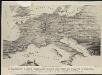
Stannard & Son's, panoramic birds-eye view of France & Prussia and the surrounding countries likely to be involved in the War, with the railways & startegic positions of each army, & the great fortresses of the Rhine provinces
1 : 1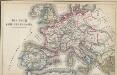
Das Reich Karl des Großen
Europa Karl I., Heiliges Römisches Reich, Kaiser
Orbis Romani Pars Occidentalis.
1 : 10137600 Lucas, Fielding Jr.
Westeuropa 1812
Westeuropa Kunz, Andreas ; Treiling, Thomas
Carte de la Germanie et les diferents etats ou ses peuples ont porté leurs conquestes
Evropa jižní Chatelain, Henri-Abraham Chatelain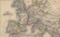
Das Zeitalter der Hohenstaufen
Mitteleuropa
Westeuropa 1848
Westeuropa Kunz, Andreas ; Röss, Wolf ; Johnen, Bettina ; Moeschl, Joachim Robert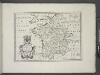
France, and parts adjoining.
from A new sett of maps both of antient and present geography : wherein not only the latitude and longitude of many places are corrected according to the latest observations, but also the most remarkable differences of antient and present geography may be quickly discern'd by a bare inspection or comparing of correspondent maps, which seems to be the most natural and easy method to lead young students (for whose use the work is principally intended) unto a competent knowledge of the geographical science : together with a geographical treatise particularly adapted to the use and design of these maps / by Edward Wells, M.A. and student of Christ-Church, Oxon.
Westeuropa 1830
Westeuropa Kunz, Andreas ; Röss, Wolf ; Johnen, Bettina ; Moeschl, Joachim Robert
Westeuropa 1890
Westeuropa Kunz, Andreas ; Röss, Wolf ; Johnen, Bettina ; Moeschl, Joachim Robert
Westeuropa 1957
Westeuropa Kunz, Andreas ; Treiling, Thomas
Westeuropa 1937
Westeuropa Kunz, Andreas ; Treiling, Thomas
Westeuropa 1922
Westeuropa Kunz, Andreas ; Treiling, Thomas