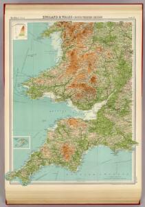
Maps of South West England

England & Wales, south-western section; Scilly Isles.
1 : 633600 John Bartholomew & Co.
England & Wales SW.
1 : 633600 Stanford, Edward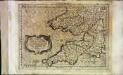
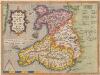
Cornvbia, Devonia, Somersetvs, Dorcestia, Wiltonia, Glocestra Monvmetha, Glamorgan, Caermarden, Penbrok, Cardigan, Radnor, Breknoke, Herefordia, [et] Wigornia
1 Karte : Kupferdruck ; 17 x 24 cm Keere; Mercator Cloppenburgh
Cornvbia, Devonia, Somersetvs, Dorcestria, Wiltonia, Glocestria Monvmetha, Glamorgan, Caermarden, Penbrok, Cardigan, Radnor, Breknoke, Herefordia, [et] Wigornia
1 Karte : Kupferdruck ; 35 x 45 cm Hondius; Mercator Henricus Hondius
Cornvbia, Devonia, Somersetvs, Dorcestria, Wiltonia, Glocestria Monvmetha, Glamorgan, Caermarden, Penbrok, Cardigan, Radnor, Breknoke, Herefordia, [et] Wigornia
1 Karte : Kupferdruck ; 35 x 45 cm Mercator; Hondius Jodocus Hondius
Charte von England und Wallis, 3
1 Blatt : 62 x 53 cm Walch
Karte von England und Wallis, 3
1 Blatt : 62 x 53 cm Schrämbl


Cornubia, Devonia, Somersetus, Dorcestria, Wiltonia, Glocestria, Monumetha, Glamorgan, Caermarden, Penbrok, Cardigan, Radnor, Breknoke, Herefordia, & Wigornia. [Karte], in: Atlas, sive, Cosmographicae meditationes de fabrica mundi et fabricati figura, S. 116.
1 Karte aus Atlas Mercator, Gerhard
Cornubia, Devonia, Somersetus, Dorcestria, Wiltonia, Glocestria, Monumetha, Glamorgan, Caermarden, Penbrok, Cardigan, Radnor, Breknoke, Herefordia, & Wigornia. [Karte], in: Gerardi Mercatoris Atlas, sive, Cosmographicae meditationes de fabrica mundi et fabricati figura, S. 121.
1 Karte aus Atlas Mercator, Gerhard Montanus, Petrus
Watershed map England, Wales 5.
1 : 760320 Letts, Son & Co.
Provinces meridionales de l'Angleterre ou côtes septentrionales de la Manche, 1
1 Blatt : 53 x 68 cm Le Rouge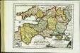
Des Königreichs England südlicher Theil, oder Cornwall, Devon Shire, Dorset S., Som[m]erset S., Bristol, Wilt S
1 Karte : Kupferdruck ; 18 x 25 cm Reilly F. J. J. von Reilly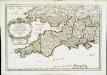
Provinces d'West; autrefois royaume d'Westsex
1 Karte : Kupferdruck ; 36 x 52 cm Sanson chez l'auteur
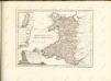
Principauté de Galles
1 Karte : Kupferdruck ; 36 x 42 cm Sanson; Fortin chez le Sr. Fortin ing.r pour les globes rue de la Harpe près celle du Foin
Principauté de Galles
1 Karte : Kupferdruck ; 36 x 42 Sanson chez l'autheur
Wallia Principatus Vulgo Wales. [Karte], in: Theatrum orbis terrarum, sive, Atlas novus, Bd. 4, S. 390.
1 Karte aus Atlas Blaeu, Joan Blaeu, Willem Janszoon
CUMBRIAE TYPUS auctore HVMFREDO LHVYD, Denbigiense Cambrobritanno
This is a map of Wales by Humpfry Lyde, after Ortelius. It forms part of an atlas that belonged to William Cecil Lord Burghley, Elizabeth I’s Secretary of State. Burghley used this atlas to illustrate domestic matters. Lyde, Humpfry
Wallia Principatus Vulgo Wales. [Karte], in: Le théâtre du monde, ou, Nouvel atlas contenant les chartes et descriptions de tous les païs de la terre, Bd. 4, S. 336.
1 Karte aus Atlas Blaeu, Willem Janszoon und Blaeu, Joan Blaeu, Willem Janszoon
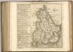
Cambriae typus
1 : 780000
Wallia Principatus Vulgo Wales. [Karte], in: Theatrum orbis terrarum, sive, Atlas novus, Bd. 4, S. 390.
1 Karte aus Atlas Blaeu, Joan Blaeu, Willem Janszoon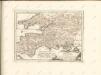
Cambriae Typus [...] [Karte], in: Theatrum orbis terrarum, S. 39.
1 Karte aus Atlas Ortelius, Abraham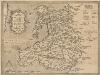
Cambriae Typus [Karte], in: Theatrum orbis terrarum, S. 86.
1 Karte aus Atlas Ortelius, Abraham Vrients, Jan Baptista

Cambriae Typus [Karte], in: Gerardi Mercatoris Atlas, sive, Cosmographicae meditationes de fabrica mundi et fabricati figura, S. 118.
1 Karte aus Atlas Mercator, Gerhard Montanus, Petrus