Maps of South West England
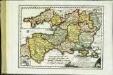
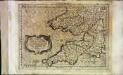
Des Königreichs England südlicher Theil, oder Cornwall, Devon Shire, Dorset S., Som[m]erset S., Bristol, Wilt S
1 Karte : Kupferdruck ; 18 x 25 cm Reilly F. J. J. von Reilly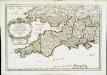
Provinces d'West; autrefois royaume d'Westsex
1 Karte : Kupferdruck ; 36 x 52 cm Sanson chez l'auteur
Cornubia, Devonia, Somersetus, Dorcestria, Wiltonia, Glocestria, Monumetha, Glamorgan, Caermarden, Penbrok, Cardigan, Radnor, Breknoke, Herefordia, & Wigornia. [Karte], in: Gerardi Mercatoris Atlas, sive, Cosmographicae meditationes de fabrica mundi et fabricati figura, S. 121.
1 Karte aus Atlas Mercator, Gerhard Montanus, Petrus
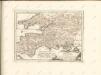
Provinces meridionales de l'Angleterre ou côtes septentrionales de la Manche, 1
1 Blatt : 53 x 68 cm Le Rouge
Cornubia, Devonia, Somersetus, Dorcestria, Wiltonia, Glocestria, Monumetha, Glamorgan, Caermarden, Penbrok, Cardigan, Radnor, Breknoke, Herefordia, & Wigornia. [Karte], in: Atlas, sive, Cosmographicae meditationes de fabrica mundi et fabricati figura, S. 116.
1 Karte aus Atlas Mercator, Gerhard
Cornvbia, Devonia, Somersetvs, Dorcestia, Wiltonia, Glocestra Monvmetha, Glamorgan, Caermarden, Penbrok, Cardigan, Radnor, Breknoke, Herefordia, [et] Wigornia
1 Karte : Kupferdruck ; 17 x 24 cm Keere; Mercator Cloppenburgh
Cornvbia, Devonia, Somersetvs, Dorcestria, Wiltonia, Glocestria Monvmetha, Glamorgan, Caermarden, Penbrok, Cardigan, Radnor, Breknoke, Herefordia, [et] Wigornia
1 Karte : Kupferdruck ; 35 x 45 cm Hondius; Mercator Henricus Hondius
Cornvbia, Devonia, Somersetvs, Dorcestria, Wiltonia, Glocestria Monvmetha, Glamorgan, Caermarden, Penbrok, Cardigan, Radnor, Breknoke, Herefordia, [et] Wigornia
1 Karte : Kupferdruck ; 35 x 45 cm Mercator; Hondius Jodocus Hondius
Watershed map England, Wales 5.
1 : 760320 Letts, Son & Co.
Charte von England und Wallis, 3
1 Blatt : 62 x 53 cm Walch
Karte von England und Wallis, 3
1 Blatt : 62 x 53 cm Schrämbl
England & Wales SW.
1 : 633600 Stanford, Edward
England & Wales, south-western section; Scilly Isles.
1 : 633600 John Bartholomew & Co.
England
1 : 778000 under the superintendence of the Society for the Diffusion of Useful Knowledge J. & C. Walker sculpt. London : Baldwin and Cradock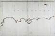
Carte de la France, no. 23
1 Blatt : 60 x 92 cm s.n.
2) I.E. ''Weymouth'', uit: Carte géologique de France
1 : 500000 Annotatie: Voor aanwezige bladen zie bladoverzicht [S.l : s.n.]
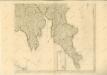
Ports & Harbours on the South East Coast of England.
Fullarton, A. & Co.
delineation of the strata of England and Wales, with part of Scotland
1 : 320000 Blatt 10 Smith, William Cary
England and Wales[OS civil air edition]
Ordnance Survey
Principatus Walliae Pars Australis: Vulgo South-Wales. [Karte], in: Novus atlas absolutissimus, Bd. 7, S. 371.
1 Karte aus Atlas Janssonius Offizin
England and Wales[OS civil air edition]
Ordnance Survey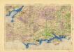
Ordnance Survey of England and Wales (Aeronautical map)
Great Britain. War Office. General Staff. Geographical Section [London] : [Air Ministry],
delineation of the strata of England and Wales, with part of Scotland
1 : 320000 Blatt 9 Smith, William Cary
Sheet 10 England, South West, uit: Maps of England & Wales : scale 4 miles to 1 inch / Ordnance Survey
1 : 253440 titelvariant: Maps of England and Wales; Annotatie: Titel op cassette; Met bladoverzicht op de achterzijde van de cassette; Annotatie geografische gegevens: Hoogtelijneninterval 200 ft Ordnance Survey, United Kingdom Southampton : Ordnance Survey Office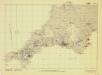
Britain, defences South of England and Wales
[London] : Ministry of Home Security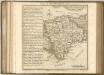

![Des Königreichs England südlicher Theil, oder Cornwall, Devon Shire, Dorset S., Som[m]erset S., Bristol, Wilt S](http://biblio.unibe.ch/web-apps/maps/zoomify.php?pic=Ryh_1803_40_B.jpg&col=ryh)

