Maps of South West England

Maps of South West England

$title$

$title$

Des Königreichs England südlicher Theil, oder Cornwall, Devon Shire, Dorset S., Som[m]erset S., Bristol, Wilt S

1 Karte : Kupferdruck ; 18 x 25 cm Reilly F. J. J. von Reilly
$title$

Provinces d'West; autrefois royaume d'Westsex

1 Karte : Kupferdruck ; 36 x 52 cm Sanson chez l'auteur
$title$

Carte de la France, no. 23

1 Blatt : 60 x 92 cm s.n.
$title$

Cornvbia, Devonia, Somersetvs, Dorcestia, Wiltonia, Glocestra Monvmetha, Glamorgan, Caermarden, Penbrok, Cardigan, Radnor, Breknoke, Herefordia, [et] Wigornia

1 Karte : Kupferdruck ; 17 x 24 cm Keere; Mercator Cloppenburgh
$title$

Cornvbia, Devonia, Somersetvs, Dorcestria, Wiltonia, Glocestria Monvmetha, Glamorgan, Caermarden, Penbrok, Cardigan, Radnor, Breknoke, Herefordia, [et] Wigornia

1 Karte : Kupferdruck ; 35 x 45 cm Hondius; Mercator Henricus Hondius
$title$

Cornvbia, Devonia, Somersetvs, Dorcestria, Wiltonia, Glocestria Monvmetha, Glamorgan, Caermarden, Penbrok, Cardigan, Radnor, Breknoke, Herefordia, [et] Wigornia

1 Karte : Kupferdruck ; 35 x 45 cm Mercator; Hondius Jodocus Hondius
$title$

$title$

England & Wales, south-western section; Scilly Isles.

1 : 633600 John Bartholomew & Co.
$title$

Watershed map England, Wales 5.

1 : 760320 Letts, Son & Co.
$title$

England & Wales SW.

1 : 633600 Stanford, Edward
$title$

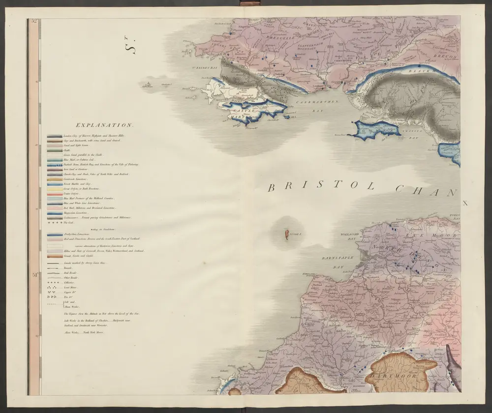
delineation of the strata of England and Wales, with part of Scotland

1 : 320000 Blatt 10 Smith, William Cary
$title$

2) I.E. ''Weymouth'', uit: Carte géologique de France

1 : 500000 Annotatie: Voor aanwezige bladen zie bladoverzicht [S.l : s.n.]
$title$

Ports & Harbours on the South East Coast of England.

Fullarton, A. & Co.
$title$

Provinces meridionales de l'Angleterre ou côtes septentrionales de la Manche, 1

1 Blatt : 53 x 68 cm Le Rouge
$title$

England

1 : 778000 under the superintendence of the Society for the Diffusion of Useful Knowledge J. & C. Walker sculpt. London : Baldwin and Cradock
$title$

Ordnance Survey of England and Wales (Aeronautical map)

Great Britain. War Office. General Staff. Geographical Section [London] : [Air Ministry],
$title$

$title$

Devonia Vulgo Devon-Shire. [Karte], in: Theatrum orbis terrarum, sive, Atlas novus, Bd. 4, S. 136.

1 Karte aus Atlas Blaeu, Joan Blaeu, Willem Janszoon
$title$

England and Wales 1:253,440

Ordnance Survey
$title$

Devonia Vulgo Devon-Shire. [Karte], in: Theatrum orbis terrarum, sive, Atlas novus, Bd. 4, S. 136.

1 Karte aus Atlas Blaeu, Joan Blaeu, Willem Janszoon
$title$

Principatus Walliae Pars Australis vulgo South-Wales

1 : 460000 Amstelodami : apud Joannem Janssonium
$title$

A new travelling map of the country round London, 3

1 Blatt : 49 x 61 cm J. Andrews & A. Drury
$title$

Devonia vulgo Devon-Shire. [Karte], in: Le théâtre du monde, ou, Nouvel atlas contenant les chartes et descriptions de tous les païs de la terre, Bd. 4, S. 120.

1 Karte aus Atlas Blaeu, Willem Janszoon und Blaeu, Joan Blaeu, Willem Janszoon
$title$

Devoniae Descriptio. The Description of Devon-Shire [Karte], in: Novus atlas absolutissimus, Bd. 7, S. 199.

1 Karte aus Atlas Janssonius Offizin
$title$

England and Wales[OS civil air edition]

Ordnance Survey
$title$

Britain, defences South of England and Wales

[London] : Ministry of Home Security
$title$

Sheet 11 England, South, uit: Maps of England & Wales : scale 4 miles to 1 inch / Ordnance Survey

1 : 253440 titelvariant: Maps of England and Wales; Annotatie: Titel op cassette; Met bladoverzicht op de achterzijde van de cassette; Annotatie geografische gegevens: Hoogtelijneninterval 200 ft Ordnance Survey, United Kingdom Southampton : Ordnance Survey Office
$title$

England south

1 : 253440 Anglie jižní Ordnance Survey Office
$title$

Hantoniae Comitatus cum Bercheria. [Karte], in: Novus atlas absolutissimus, Bd. 7, S. 153.

1 Karte aus Atlas Janssonius Offizin
© MapTiler © OpenStreetMap contributors
How does it work?
These instructions will show you how to find historical maps online.
Getting started
Type the place name in the search box to find the exact location. You can further adjust the search by zooming in and out.
Zoom
Zoom in and out with the buttons or use your mouse or touchpad natively.
Exact Area tool
Click here and draw a rectangle over the map to precisely define the search area.
Set filters
Narrow your search with advanced settings, such as Years (from/to), Fulltext, Publisher, etc.
Results
See the results of your search on the right side. You can scroll down to find more maps of this location.
?

Download OldMapsOnline Mobile