Maps of Cambridge
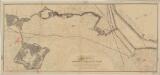
Boston et Ses Environs.
1 : 52000 Marshall, John
Boston and Vicinity.
1 : 21500 Johnson, A.J.
Boston and Vicinity.
1 : 21500 Johnson, A.J.
Boston and Vicinity.
Gray, Ormando Willis
Boston and vicinity.
1 : 21500 Johnson, A.J.
Boston and Adjacent Cities.
1 : 19500 Colton, G.W.
Boston.
1 : 19800 Walling, H. F.
Map of the city of Boston and immediate neighborhood : from original surveys
1 : 5400 McIntyre, H. (Henry) H. McIntyre
Proposed Charles River park
1 : 21100 Davenport, Charles J.H. Bufford's Sons
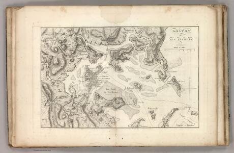
Plan of the town of Boston and circumjacent country shewing the present situation of the Kings troops & the Rebels Intrenchments 25th July 1775
D'Auvergne, Philip, Prince de Bouillon
A new & complete map of the city of Boston : with part of Charlestown, Cambridge, Brookline, Dorchester &c
E.P. Dutton (Firm) E.P. Dutton & Co.
Map of the city of Boston and its environs
1 : 14500 G.M. Hopkins & Co G.M. Hopkins & Co.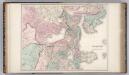
Boston and Vicinity.
1 : 19400 Gray, Ormando Willis
Plan of Boston and its vicinity showing the connection of the Grand Junction Rail Road with the Harbor and other Rail-roads
1 : 37500 Tappan & Bradford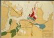
Map of Boston Inner Harbor
1 : 7210 Massachusetts. Directors of the Port of Boston Massachusetts. Directors of the Port of Boston
Boston
1 : 21000 Wood Brothers
Plan of Boston.
from Mitchell's new general atlas, containing maps of the various countries of the world, plans of cities, etc., embraced in fifty-three quarto maps., forming a series of eighty four maps and plans, together with valuable statistical tables.
Boston.
1 : 13000 Haynes, Tilly
Boston and Adjacent Cities.
1 : 19500 Colton, G.W.
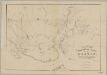
Map of the town of Roxbury
Hales, John Groves Boston (Mass.).
A plan of those parts of Boston and the towns in its vicinity : with the waters and flats adjacent which are immediately or remotely connected with the contemplated design of erecting perpetual tide-mills
1 : 15840 Dearborn, Benjamin, 1754-1838 Benjamin Dearborn
New map of Boston : with squares and numbers after the Baedeker plan
1 : 8350 Boston Map Co.
Boston and Adjacent Cities.
1 : 20000 Colton, G.W.
Boston and Adjacent Cities.
1 : 19500 Colton, G.W.
A New and Complete Map of the city of Boston, with part of Charlestown, Cambridge, & Roxbury
Rail-road crossings and termini in the vicinity of Boston : compiled under the direction of the commissioner appointed by the governor to report upon a plan or plans for avoiding said crossings
1 : 7200 Perkins, Charles E., 1951- Tappan & Bradford's Lithogy.
Boston and Adjacent Cities.
1 : 20000 Colton, G.W.
Boston, pt. of Charlestown, Cambridge.
1 : 7000 Smith, George G.
Boston.
1 : 16500 Rand McNally and Company