Maps of Cambridge

A plan of those parts of Boston and the towns in its vicinity : with the waters and flats adjacent which are immediately or remotely connected with the contemplated design of erecting perpetual tide-mills
1 : 15840 Dearborn, Benjamin, 1754-1838 Benjamin Dearborn
Boston and Vicinity.
1 : 19400 Gray, Ormando Willis
Plan of the town of Boston and circumjacent country shewing the present situation of the Kings troops & the Rebels Intrenchments 25th July 1775
D'Auvergne, Philip, Prince de Bouillon
Map of the city of Boston and immediate neighborhood : from original surveys
1 : 5400 McIntyre, H. (Henry) H. McIntyre
Boston
1 : 21000 Wood Brothers
A plan of those parts of Boston, and the towns in its vicinity, with the waters and flats adjacent, which are immediately or remotely connected with the contemplated design of erecting perpetual tide-mills
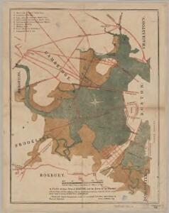
Plan of portion of park system from Common to Franklin Park : including Charles River Basin, Charlesbank, Commonwealth Avenue, Back Bay Fens, Muddy River Improvement, Leverett Park, Jamaica Park, Arborway and Arnold Arboretum
1 : 9000 Olmsted, Olmsted, and Eliot City of Boston, Park Dept.
Plan of Boston and its vicinity showing the connection of the Grand Junction Rail Road with the Harbor and other Rail-roads
1 : 37500 Tappan & Bradford
Boston.
1 : 13000 Haynes, Tilly
Plan of Boston.
from Mitchell's new general atlas, containing maps of the various countries of the world, plans of cities, etc., embraced in fifty-three quarto maps., forming a series of eighty four maps and plans, together with valuable statistical tables.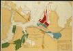
Map of Boston Inner Harbor
1 : 7210 Massachusetts. Directors of the Port of Boston Massachusetts. Directors of the Port of Boston
Boston and Adjacent Cities.
1 : 19500 Colton, G.W.
Boston, pt. of Charlestown, Cambridge.
1 : 7000 Smith, George G.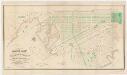
Plan of lands on the Back Bay : belonging to the Boston Water Power Co., the Commonwealth, and other parties, showing the system of streets & grades as laid out and recommended by the Back Bay Commissioners
1 : 3600 Boston (Mass.). Back Bay Commissioners A. Meisel, lith.
New map of Boston : with squares and numbers after the Baedeker plan
1 : 8350 Boston Map Co.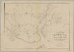
Rail-road crossings and termini in the vicinity of Boston : compiled under the direction of the commissioner appointed by the governor to report upon a plan or plans for avoiding said crossings
1 : 7200 Perkins, Charles E., 1951- Tappan & Bradford's Lithogy.
Map of the town of Roxbury
Hales, John Groves Boston (Mass.).
Boston and Adjacent Cities.
1 : 19500 Colton, G.W.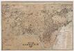
City of Cambridge, Mass
[s.n.]
Plan of Boston comprising a part of Charlestown and Cambridge
1 : 7310 Smith, George Girdler, 1795-1878 George G. Smith
Boston and Adjacent Cities.
1 : 20000 Colton, G.W.
Boston and Adjacent Cities.
1 : 20000 Colton, G.W.
Plan of Boston comprising a part of Charlestown and Cambridge
1 : 7380 Smith, George Girdler, 1795-1878 George G. Smith
Plan of Boston comprising a part of Charlestown and Cambridgeport
1 : 6090 Fuller, Stephen P Annin & Smith ; J.V.N. Throop
Plan of Boston comprising a part of Charlestown and Cambridge
1 : 7310 Smith, George Girdler, 1795-1878 George G. Smith
An accurate plan of the town of Boston and its vicinity : exhibiting a ground plan of all the streets, lanes, alleys, wharves, and public buildings in Boston, with the names and description thereof, likewise all the flats and channels between Boston and Charlestown, Cambridge, Roxbury & Dorchester with the two bridges and causeway, and the boundary lines beween Boston and the above mentioned towns from ...
1 : 4170 Carleton, Osgood, 1742-1816 Published and sold by Osgood Carleton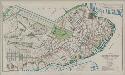
Plan of Boston proper : showing changes in street and wharf lines, 1795 to 1895
1 : 4800 Perkins, Charles Carroll H.H. Lloyd
Boston.
1 : 16500 Rand McNally and Company
Map of the city of Cambridge, Middlesex County, Massachusetts
1 : 6000 Walling, Henry Francis, 1825-1888 Geo. L. Dix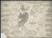
Plan of Boston with parts of the adjacent towns