Maps of Boston

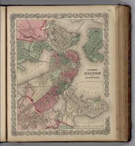
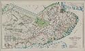
Boston and Adjacent Cities.
1 : 20000 Colton, G.W.
Boston and Adjacent Cities.
1 : 20000 Colton, G.W.
Boston and Adjacent Cities.
1 : 19500 Colton, G.W.
New map of Boston : with squares and numbers after the Baedeker plan
1 : 8350 Boston Map Co.
Boston.
1 : 13000 Haynes, Tilly
Boston and Adjacent Cities.
1 : 19500 Colton, G.W.
Plan of Boston with parts of the adjacent towns
Plan of Boston with parts of the adjacent towns

Plan of Boston.
from Mitchell's new general atlas, containing maps of the various countries of the world, plans of cities, etc., embraced in fifty-three quarto maps., forming a series of eighty four maps and plans, together with valuable statistical tables.
Boston
1 : 21000 Wood Brothers
Map of Boston Inner Harbor
1 : 7210 Massachusetts. Directors of the Port of Boston Massachusetts. Directors of the Port of Boston
Boston, pt. of Charlestown, Cambridge.
1 : 7000 Smith, George G.
Boston and Adjacent Cities.
1 : 20000 Colton, G.W.
A New and Complete Map of the city of Boston, with part of Charlestown, Cambridge, & Roxbury
Plan of Boston proper : showing changes in street and wharf lines, 1795 to 1895
1 : 4800 Perkins, Charles Carroll H.H. Lloyd
Boston.
1 : 16500 Rand McNally and Company
Plan of Boston comprising a part of Charlestown and Cambridge
1 : 7310 Smith, George Girdler, 1795-1878 George G. Smith
Boston: Bird's-eye view from the North
Bachmann, John L. Prang & Co.
Plan of Boston comprising a part of Charlestown and Cambridgeport
1 : 6090 Fuller, Stephen P Annin & Smith ; J.V.N. Throop
Plan of Boston comprising a part of Charlestown and Cambridge
1 : 7380 Smith, George Girdler, 1795-1878 George G. Smith
New map of Boston, comprising the whole city with the new boundaries of the wards
Forbes Lithograph Manufacturing Company
New map of Boston, comprising the whole city, with the new boundaries of the wards
Boynton, George W.
New map of Boston, comprising the whole city, with the new boundaries of the wards
Boynton, George W.
Plan of Boston comprising a part of Charlestown and Cambridge
1 : 7310 Smith, George Girdler, 1795-1878 George G. Smith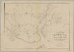
Rail-road crossings and termini in the vicinity of Boston : compiled under the direction of the commissioner appointed by the governor to report upon a plan or plans for avoiding said crossings
1 : 7200 Perkins, Charles E., 1951- Tappan & Bradford's Lithogy.
Map of the town of Roxbury
Hales, John Groves Boston (Mass.).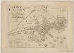
The town of Boston in New England
1 : 5600 Bonner, John, ca. 1643-1726 George G. Smith
Boston with Charlestown and Roxbury

A map of the city of Boston in Massachusetts
1 : 7920 Bookshop for Boys and Girls (Boston, Mass.)