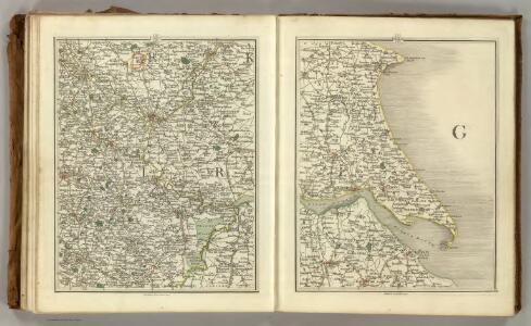
Maps of East Riding of Yorkshire
Sheets 51-52. (Cary's England, Wales, and Scotland).
1 : 360000 Cary, John, ca. 1754-1835
Ducatus Eboracensis Pars Orientalis; The Eastriding of Yorkeshire [Karte], in: Le théâtre du monde, ou, Nouvel atlas contenant les chartes et descriptions de tous les païs de la terre, Bd. 4, S. 391.
1 Karte aus Atlas Blaeu, Willem Janszoon und Blaeu, Joan Blaeu, Willem Janszoon
Ducatus Eboracensis Pars Orientalis; The Eastriding of Yorkeshire. [Karte], in: Theatrum orbis terrarum, sive, Atlas novus, Bd. 4, S. 453.
1 Karte aus Atlas Blaeu, Joan Blaeu, Willem Janszoon
Ducatus Eboracensis Pars Orientalis; The Eastriding of Yorkeshire. [Karte], in: Theatrum orbis terrarum, sive, Atlas novus, Bd. 4, S. 453.
1 Karte aus Atlas Blaeu, Joan Blaeu, Willem Janszoon
Ducatus Eboracensis Pars Orientalis. The Eastriding of Yorke Shire. [Karte], in: Novus atlas absolutissimus, Bd. 8, S. 38.
1 Karte aus Atlas Janssonius Offizin
DVCATVS | EBORACENSIS | PARS ORIENTALIS; | The Eastriding of Yorkeshire.
[Amsterdam : Joan Blaeu]
Dvcatvs Eboracensis pars orientalis
1 Karte : Kupferdruck ; 36 x 48 cm Valck; Schenk ex typographia Gerardi Valk et Petri Schenk
Dvcatvs Eboracensis pars orientalis
1 Karte : Kupferdruck ; 37 x 49 cm Blaeu Joan Blaeu
Hull - OS One-Inch Map
1 : 63360 Topographic maps Ordnance Survey Ordnance Survey
Market Weighton - OS One-Inch Map
1 : 63360 Topographic maps Ordnance Survey Ordnance Survey
York - OS One-Inch Map
1 : 63360 Topographic maps Ordnance Survey Ordnance Survey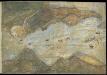
Humber from Hull and Barton to Sea
This is a map showing the River Humber, River Hull and the town of hull. It dates from between 1541-1547. The map is drawn in a loose pictorial style but despite this the defences of Hull are shown in accurate detail. These fortifications were built under the instruction of Henry VIII to protect the eastern side of the town. Plans for the building work were made in 1541 after the king visited in October of that year and dictated that the eastern side of the town, defended only by the River Hull, must be strengthened. At this time Henry VIII feared an invasion from the combined forces of France and Spain. In 1538 Francis I of France, and Charles V Holy Roman Emperor and King of Spain signed a peace treaty. This union gave rise to the possibility that France and Spain may combine forces to invade England. France was England’s historical enemy and Henry VIII’s divorce of Catherine of Aragon, Charles V’s aunt, had offended the militantly catholic King of Spain. The town of Hull, located on the east coast of the country, near the Anglo-Scottish border occupies a position of strategic importance as it provided a base for war against Scotland or Catholic Europe As can be seen here the fortifications at Hull consisted of two large trefoil headed blockhouses’ or bulwarks’ at opposite ends of the harbour, with a castle’ between them. Connecting these fortresses was a crenellated wall almost half a mile long running parallel to the river. This would provide defences which could protect against overland attack from the east, or naval invasion from the Humber. The draughtsman has accurately recorded the unusual trefoil shapes of the bulwarks, the segmental forms of the castle and the angled bend and crenellations of the connecting wall. In December 1543 costs were given as 21,056 5s. 6d in total. This chart could date from as early as October 1541, when the King visited Hull in October 1541 and expressed concern that the east side of the town was vulnerable to an attack.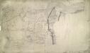
Crowle
1 : 31680 This plan covering the tidal Humber Estuary and the confluence of the rivers Trent and Humber in north Lincolnshire. Along the Humber, the draughtsman has drawn lines or stripes at right angles to the flow of the water. This is an unusual technique: lines were usually drawn parallel to to the course. A section of the Stainforth and Keadby Canal is shown in blue at the bottom of the map, near Althorpe. The manuscript paper carries a watermark from the James Whatman Turkey Mill, Kent, dated 1816. Budgen, Charles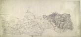
Howden
1 : 31680 This drawing covers the north bank of the Humber estuary. Fenland dominates the landscape of this part of Yorkshire. Dykes and canals built to drain the region are highlighted in blue to the left of the sheet. To the right, brushwork interlining ('hachuring') indicates relief. Budgen, Charles
Bridlington (Hills) - OS One-Inch Revised New Series
1 : 63360 Topographic maps Ordnance Survey Ordnance Survey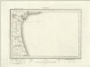
Bridlington (Outline) - OS One-Inch Revised New Series
1 : 63360 Topographic maps Ordnance Survey Ordnance Survey
Hornsea (Hills) - OS One-Inch Revised New Series
1 : 63360 Topographic maps Ordnance Survey Ordnance Survey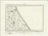
Hornsea (Outline) - OS One-Inch Revised New Series
1 : 63360 Topographic maps Ordnance Survey Ordnance Survey
Patrington (Hills) - OS One-Inch Revised New Series
1 : 63360 Topographic maps Ordnance Survey Ordnance Survey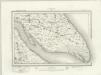
Patrington (Outline) - OS One-Inch Revised New Series
1 : 63360 Topographic maps Ordnance Survey Ordnance Survey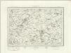
Great Driffield (Outline) - OS One-Inch Revised New Series
1 : 63360 Topographic maps Ordnance Survey Ordnance Survey
Great Driffield (Hills) - OS One-Inch Revised New Series
1 : 63360 Topographic maps Ordnance Survey Ordnance Survey
Beverley (Hills) - OS One-Inch Revised New Series
1 : 63360 Topographic maps Ordnance Survey Ordnance Survey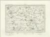
Beverley (Outline) - OS One-Inch Revised New Series
1 : 63360 Topographic maps Ordnance Survey Ordnance Survey
Kingston upon Hull (Hills) - OS One-Inch Revised New Series
1 : 63360 Topographic maps Ordnance Survey Ordnance Survey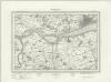
Kingston upon Hull (Outline) - OS One-Inch Revised New Series
1 : 63360 Topographic maps Ordnance Survey Ordnance Survey
York (Hills) - OS One-Inch Revised New Series
1 : 63360 Topographic maps Ordnance Survey Ordnance Survey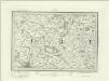
York (Outline) - OS One-Inch Revised New Series
1 : 63360 Topographic maps Ordnance Survey Ordnance Survey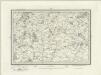
Selby (Outline) - OS One-Inch Revised New Series
1 : 63360 Topographic maps Ordnance Survey Ordnance Survey