Maps of East Riding of Yorkshire

Dvcatvs Eboracensis pars orientalis
1 Karte : Kupferdruck ; 36 x 48 cm Valck; Schenk ex typographia Gerardi Valk et Petri Schenk
Dvcatvs Eboracensis pars orientalis
1 Karte : Kupferdruck ; 37 x 49 cm Blaeu Joan Blaeu
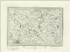
Ducatus Eboracensis Pars Orientalis. The Eastriding of Yorke Shire. [Karte], in: Novus atlas absolutissimus, Bd. 8, S. 38.
1 Karte aus Atlas Janssonius Offizin
DVCATVS | EBORACENSIS | PARS ORIENTALIS; | The Eastriding of Yorkeshire.
[Amsterdam : Joan Blaeu]
Ducatus Eboracensis Pars Orientalis; The Eastriding of Yorkeshire. [Karte], in: Theatrum orbis terrarum, sive, Atlas novus, Bd. 4, S. 453.
1 Karte aus Atlas Blaeu, Joan Blaeu, Willem Janszoon
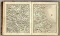
Ducatus Eboracensis Pars Orientalis; The Eastriding of Yorkeshire [Karte], in: Le théâtre du monde, ou, Nouvel atlas contenant les chartes et descriptions de tous les païs de la terre, Bd. 4, S. 391.
1 Karte aus Atlas Blaeu, Willem Janszoon und Blaeu, Joan Blaeu, Willem Janszoon
Ducatus Eboracensis Pars Orientalis; The Eastriding of Yorkeshire. [Karte], in: Theatrum orbis terrarum, sive, Atlas novus, Bd. 4, S. 453.
1 Karte aus Atlas Blaeu, Joan Blaeu, Willem Janszoon
Generalkarte von Zentraleuropa
Sheets 51-52. (Cary's England, Wales, and Scotland).
1 : 360000 Cary, John, ca. 1754-1835
York & Scarborough, Sheet 7 - Bartholomew's "Half Inch to the Mile Maps" of England & Wales
1 : 126720 Topographic maps Bartholomew, John George John Bartholomew & Co
Hull - OS One-Inch Map
1 : 63360 Topographic maps Ordnance Survey Ordnance Survey
Market Weighton - OS One-Inch Map
1 : 63360 Topographic maps Ordnance Survey Ordnance Survey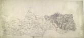
Howden
1 : 31680 This drawing covers the north bank of the Humber estuary. Fenland dominates the landscape of this part of Yorkshire. Dykes and canals built to drain the region are highlighted in blue to the left of the sheet. To the right, brushwork interlining ('hachuring') indicates relief. Budgen, Charles
Flamborough (Outline) - OS One-Inch Revised New Series
1 : 63360 Topographic maps Ordnance Survey Ordnance Survey
Flamborough (Hills) - OS One-Inch Revised New Series
1 : 63360 Topographic maps Ordnance Survey Ordnance Survey
Bridlington (Hills) - OS One-Inch Revised New Series
1 : 63360 Topographic maps Ordnance Survey Ordnance Survey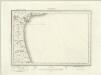
Bridlington (Outline) - OS One-Inch Revised New Series
1 : 63360 Topographic maps Ordnance Survey Ordnance Survey
Hornsea (Hills) - OS One-Inch Revised New Series
1 : 63360 Topographic maps Ordnance Survey Ordnance Survey
Hornsea (Outline) - OS One-Inch Revised New Series
1 : 63360 Topographic maps Ordnance Survey Ordnance Survey
Scarborough (Outline) - OS One-Inch Revised New Series
1 : 63360 Topographic maps Ordnance Survey Ordnance Survey
Scarborough (Hills) - OS One-Inch Revised New Series
1 : 63360 Topographic maps Ordnance Survey Ordnance Survey
Great Driffield (Outline) - OS One-Inch Revised New Series
1 : 63360 Topographic maps Ordnance Survey Ordnance Survey
Great Driffield (Hills) - OS One-Inch Revised New Series
1 : 63360 Topographic maps Ordnance Survey Ordnance Survey
Beverley (Hills) - OS One-Inch Revised New Series
1 : 63360 Topographic maps Ordnance Survey Ordnance Survey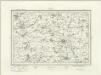
Beverley (Outline) - OS One-Inch Revised New Series
1 : 63360 Topographic maps Ordnance Survey Ordnance Survey
Kingston upon Hull (Hills) - OS One-Inch Revised New Series
1 : 63360 Topographic maps Ordnance Survey Ordnance Survey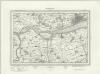
Kingston upon Hull (Outline) - OS One-Inch Revised New Series
1 : 63360 Topographic maps Ordnance Survey Ordnance Survey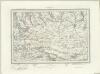
Pickering (Outline) - OS One-Inch Revised New Series
1 : 63360 Topographic maps Ordnance Survey Ordnance Survey
Pickering (Hills) - OS One-Inch Revised New Series
1 : 63360 Topographic maps Ordnance Survey Ordnance Survey
York (Hills) - OS One-Inch Revised New Series
1 : 63360 Topographic maps Ordnance Survey Ordnance Survey