Maps of Coastal Plain

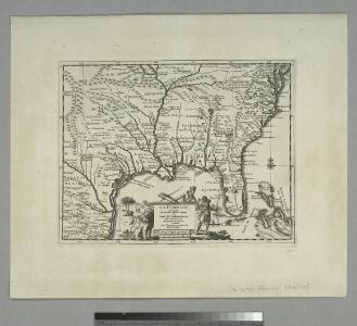
La Floride: suivant les nouvelles observations de Messrs. de l'Academie royale des sciences, etc. augmentées de nouveau. / A Leide, Chez Pierre Vander A.A., avec privilege.
from John H. Levine Collection Pierre Vander A.A.,
La Florida. [Karte], in: Theatrum orbis terrarum, S. 74.
1 Karte aus Atlas Ortelius, Abraham Vrients, Jan Baptista
La Floride, suivant les nouvelles observations de Messrs. de l'Academie des Sciences, etc.
1 : 9000000 Aa, Pieter van der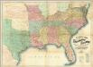
Lloyd's Map Of The Southern States.
1 : 2027520 Lloyd, J. T.
Johnson's new rail road & county copper plate map of the Southern States from the latest and best information
1 : 3150000 Johnson, A. J. Johnson & Browning
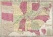
Map, showing the Distribution of Slaves in the Southern States. Projected and compiled by A. von Steinwehr.
Map, showing the Distribution of Slaves in the Southern States. Projected and compiled by A. von Steinwehr. This map shows the breakdown of slave-ownership by each county with the darker colour indicating a higher percentage of slaves. The map includes a smaller depiction of where the majority of cotton and sugar production occurred. The map thus shows the extent of the slave system before the war. Von Steinwehr was German-born general in the Union Army who fought at many of the war’s prominent battles, including the First Battle of Bull Run and the Battle of Gettysburg. Alongside fighting, he was a keen cartographer, as this map demonstrates.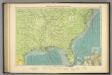
American Atlantic ports S.
1 : 5000000 Philip, George
War Maps And Diagrams. Our Naval And Military Operations At A Glance.
1 : 6336000 New York Herald
Southern section of the United States, including Florida &c. / by John Melish, 1816.
from Parts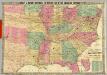
Historical And Military Map Of The Border & Southern States.
1 : 2534400 Phelps & Watson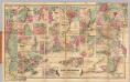
Colton's Plans Of U.S. Harbors.
Colton, J. H.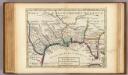
Florida called by ye French Louisiana &c.
1 : 10250000 Moll, Herman, d. 1732
Southern Section of the United States including Florida.
1 : 3928320 Melish, John
Southern Section of the United States including Florida.
1 : 3928320 Melish, John
Map of the United States of North America / compiled from the latest and most authentic information by David H. Vance ; engraved by J.H. Young.
From Whole
The Historical War Map.
1 : 3294720 Russell, Benjamin B.
Perrine's New Military Map Illustrating The Seat of War.
1 : 2724480 Perrine, Charles O.
Southern, Western States.
1 : 6000000 Cornell, S. S. (Sarah S.)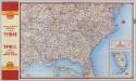
Shell Highway Map Southeastern Section of the United States.
1 : 3231360 Shell Oil Company
Hanmer's Map of the American Cotton States
Hanmer's Map of the American Cotton States. Produced in 1902 for the Liverpool cotton brokers, Hanmer & Co., this map shows the extent of cotton production in America. The map covers virtually all of the Southern states as well as several of the Border State regions. The map is a good example of how prolific cotton production was in America, though it is worth noting that cotton harvesting was undertaken by slaves, thus the map highlights the areas where slavery was most prevalent. All eleven seceded states appear on this map, demonstrating just why the Confederates believed cotton and slavery to be the cornerstones of their independence and prowess.
New map of the states of Georgia South and North Carolina Virginia and Maryland : including the Spanish provinces of West and East Florida from the latest surveys / Cornelius Tieboout, sculp. N. York.
from Charts and maps
The historical war map

Cours du Mississippi comprenant la Louisiane
1 : 5068800 Herbin de Halle, Etienne de.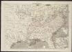
Frank Leslie's war maps
Leslie, Frank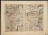
La Florida. Auctore Hieron Chiaves.
When first issued in 1584 as a copper engraving by Ortelius in his Theatrum Orbis Terrarum 1584-1612, this was one of the few sixteenth century maps based on Spanish sources; in this case drawn from reports of Hernando de Soto's expedition through the region. There are three maps on this sheet. The most important map (La Florida) is the first printed map of the southeastern portion of the United States. This influential map provided the foundation cartography for the region, particularly in the depiction of the river system. The map below (Guastecan Reg) combines with La Florida to extend the coastline of the Gulf of Mexico further south. The third is a map of Peru, where De Soto was the first Spaniard to meet Inca Emperor Atahuallpa. In the north of the map of Peru is Aurea Regio, or Kingdom of Gold, a reference to the fabled El Dorado. Text on verso. Chaves, Geronimo, 1523-1574.;Ortelius, Abraham, 1527-1598. Ortelius, Abraham, 1527-1598.
S. section U.S.
1 : 4200000 Melish, John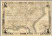
Map Of The Southern States
1 : 3612000 Harper's Weekly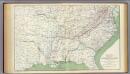
Colton's U.S. section.
1 : 3168000 United States. War Department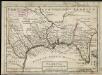
Florida called by ye French Louisiana &c.
1 : 150000 Moll, Herman Bowles, Thomas