Maps of Central Lowland

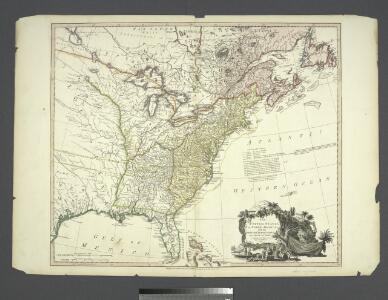
The United States of North America : with the British territories and those of Spain, according to the treaty of 1784 / engrav'd by Wm. Faden.
from John H. Levine Collection
Composite: North America, West India Islands.
1 : 5300000 Pownall, Thomas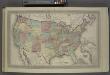
Map of The United States
from Atlas of Wayne County, New York : from actual surveys and official records / compiled & published by D. G. Beers & Co.
North America from the French of Mr. D'Anville : improved with the back settlements of Virginia and course of Ohio : illustrated with geographical and historical remarks.
from A summary, historical and political, of the first planting, progressive improvements, and present state of the British settlements in North-America ... By William Douglass, M.D. ... Boston, New-England, Printed:
A general map of North America : from the latest observations / J. Lodge sculp.
from The Constitutions of the several independent states of America; the Declaration of independence; the Articles of confederation between the said states; the treaties between His Most Christian Majesty and the United States of America. With an appendix, containing an authentic copy of the treaty concluded between Their High Mightinesses the States-General and the United States of America, and the provisional treaty. Pub. by order of Congress. Philadelphia printed. London reprinted, with an advertisement by J.L. de Lolme.
A map of the British Empire in America: with the French, Spanish and Hollandish settlements adjacent thereto / by Henry Popple; I. Condet s.
from John H. Levine Collection Henry Popple; I. Condet s.,
Amerique septentrionale: suivant la carte de Pople faite à Londres en 20 feuilles.
from Charts and maps Par et chez le Sr. le Rouge ...: Paris; Lawson, Oscar A.; Le Rouge, Georges-Louis,
America Septentrionalis A Map of the British Empire in America.
1 : 11000000 Popple, Henry
Composite: British Empire in America.
1 : 2000000 Popple, Henry
A new map of ye north parts of America claimed by France : under ye names of Louisiana, Mississipi, Canada & New France with the adjoyning territories of England & Spain / By H. Moll, geographer.
from Charts and maps

A new and correct map of North America : in which the places of the principal engagements during the present war are accurately inserted
from Parts
Carte générale de l'Amérique séptentrionale: avec les posséssions Angloises dans cette partie du nouveau monde / dressée sur la carte de Pople [sic], publiée à Londres en 20 feuilles, pour servir à l'intelligence de la guerre présente.
from Whole Henry Popple,
Theatre de la guerre presente en Amerique.
from Revolutionary War, 1775-1783
Map Of The United States, British & Central America.
1 : 3540000 Rogers, Henry Darwin
A map of the British dominions in North America, according to the Treaty in 1763 / by Peter Bell, geographer, 1772.
from The history of the British dominions in North America: from the first discovery of that vast continent by Sebastian Cabot in 1497, to its present glorious establishment as confirmed by the late treaty of peace in 1763 ...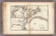
Gulf-Stream.
1 : 15000000 Vincent
Accurata delineatio celeberrimae regionis Ludovicianae vel Gallice Louisiane ot. Canadae et Floridae adpellatione in Septemtrionali America: descriptae quae hodie nomine fluminis Mississippi vel St. Louis per colonias et navigationes Gallorum ob immensas opes et adfluentiam magis magisque inclarescit ex fide digniss.
from John H. Levine Collection s.n.: [Augspurg]; Rogg, Gottfried; Seutter, Matthaeus,
Accurata delineatio celeberrimae Regionis Ludovicianae vel Gallice Louisiane
1 : 12000000 Rogg, Gottfried, 1669-1742
Composite: North America.
1 : 5400000 Robert Laurie & James Whittle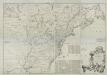
A map of the British and French dominions in North America : with the roads, distances, limits, and extent of the settlements, humbly inscribed to the Right Honourable the Earl of Halifax, and the other Right Honourable the Lords Commissioners for Trade
from Parts
America Septentrionalis. A Map of the British Empire in America.
1 : 11000000 Popple, Henry
Composite: Amerique Septentrionale.
1 : 6300000 Anville, Jean Baptiste Bourguignon d, 1697-1782
Map of the United States of North America / compiled from the latest and most authentic information by David H. Vance ; engraved by J.H. Young.
from Whole
Composite: North America.
1 : 5400000 Jefferys, Thomas
A new map of North America with the West India Islands: divided according to the preliminary articles of peace, signed at Versailles, 20, Jan. 1783; wherein are particularly distinguished the United States and the several provinces, governments & ca. which compose the British dominions / laid down according to the latest surveys and corrected from the original materials of Goverr. Pownall, Membr. of Parliamt., 1783.
from Charts and maps Governor Pownall,
North America / performed under the patronage of Louis Duke of Orleans, First Prince of the Blood by the Sieur d'Anville ; greatly improved by Mr. Bolton ; engrav,d by R. W. Seale ; Gravelot, delin. ; Walker, sculp.
from Whole
Map Of The United States The British Provinces Mexico &c.
1 : 14000000 Colton, J. H.
A map of Florida and ye Great Lakes of Canada / by Robt. Morden.
from Atlas terrestris / by Robt. Morden.