Maps of United States

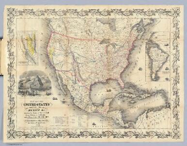
Map Of The United States The British Provinces Mexico &c.
1 : 14000000 Colton, J. H.
United States, Mexico, Central America, Caribbean.
1 : 1584000 Smith, J. Calvin
Standard American Map.
1 : 3168000 Monk, Jacob
Continental Map Of North America.
1 : 3041280 Monk, Jacob
Special -Karte der Vereinigten Staaten von Nord - America No 16.

Central America.
1 : 16600000 Sharpe, J.
Map of the United States of America, the British provinces, Mexico, the West Indies and Central America, with part of New Granada and Venezuela / map drawn by Geo. W. Colton ; engraved by John M. Atwood ; border desig'd. & eng'd. by W. S. Barnard.
From Parts
North America / performed under the patronage of Louis Duke of Orleans, First Prince of the Blood by the Sieur d'Anville ; greatly improved by Mr. Bolton ; engrav,d by R. W. Seale ; Gravelot, delin. ; Walker, sculp.
from Whole
America Septentrionalis.
from Whole Excudit Ioannes Ianssonius: Amstelodami; Jansson, Jan,
America septentrionalis
Severní Amerika Janssonius, Johannes excudit Ioannes Ianßonius
America septentrionalis
1 : 18800000 Severní Amerika Delisle, Guillaume Lotter, Georg F. apud Tobiam Conr. Lotter
America septentrionalis
1 : 18800000 Severní Amerika Delisle, Guillaume Lotter, Georg F. apud Tobiam Conr. Lotter
America septentrionalis
1 : 18800000 Severní Amerika Delisle, Guillaume Lotter, Georg F. apud Tobiam Conr. Lotter
America septentrionalis
1 : 20000000 Severní Amerika Delisle, Guillaume Lotter, Georg F. T. C. Lotter
Charte von Nordamerica
1 Karte : Kupferdruck ; 57 x 50 cm Reichard im Verlage des Industrie Comptoirs
Map of the United States of America, the British provinces, Mexico, the West Indies and Central America, with part of New Granada and Venezuela / map drawn by Geo. W. Colton ; engraved by John M. Atwood ; border desig'd. & eng'd. by W. S. Barnard.
from Parts
Charte von Nord-America
1 : 20500000 Severní Amerika
CHARTE von NORD-AMERICA
1 : 20500000 Severní Amerika
[Vereinigte Staaten von Nord-Amerika]
Hypsometrischer Atlas Ziegler, Jakob Melchior Topogr. Anstalt v. J. Wurster u. Comp.
Stromgebiet von Nordamerica
Grosser Hand-Atlas über alle Theile der Erde in 170 Karten Meyer, J. Verlag des Bibliographischen Instituts
A New map of North America with the West India Islands : divided according to the preliminary articles of peace, signed at Versailles, 20, Jan. 1783, wherein are particularly distinguished the United States, and the several provinces, governments &ca
from Whole
America Septentrionalis. [Karte], in: Novus atlas absolutissimus, Bd. 6, S. 197.
1 Karte aus Atlas Janssonius Offizin
Map of the United States of America, the British Provinces, Mexico, the West Indies and Central America, with part of New Granada and Venezuela
1 : 6400000 Colton, George Woolworth Colton, J. H. (Joseph Hutchins)
North America / performed under the patronage of Louis Duke of Orleans, First Prince of the Blood by the Sieur d'Anville ; greatly improved by Mr. Bolton ; engrav,d by R. W. Seale ; Gravelot, delin. ; Walker, sculp.
from Charts and maps
Map of The United States, and Territories. Together with Canada & c. ; Island of Newfoundland
from Atlas of Schuyler County, New York : from actual surveys by and under the direction of Beach Nichols.
Ethnographische Karte von Nordamerika
Zweiter Band, enthaltend in vier Abtheilungen die Vertheilung der Organismen: 5. Pflanzen-Geographie, 6. Thier-Geographie, 7. Anthropographie, 8. Ethnographie Humboldt, Alexander von Verlag von Justus Perthes
A map of North America with the European settlements & whatever else is remarkable in ye West Indies from the latest and best observations / R.W. Seale delin. et sculp.
from Whole R.W. Seale,
Map Of The United States Of America.
1 : 16526080 Colton, J. H.
Map Of The United States, Canada, Mexico, Central America, West Indies, &c.
1 : 3380000 Williams, G. Washington.