Maps of New York

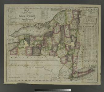
Map of the state of New York: with the latest improvements / by H. Phelps.
from Whole H. Phelps,
State of New York / by D.H. Burr; engraved & printed by S. Stiles & Co.
from Whole David H. Burr; S. Stiles & Co.,
New-York / by David H. Burr; engraved & printed by S. Stiles.
from Whole David H. Burr; S. Stiles.,
Map of the state of New York: showing the boundaries of counties & townships, the location of cities, towns and villages: the courses of railroads, canals & stage roads / by J. Calvin Smith; engraved on steel by Sherman & Smith.
from Whole J. Calvin Smith; Sherman & Smith,
Map of the state of New York: showing the boundaries of counties & townships, the location of cities, towns and villages, the courses of rail roads, canals & stage roads / by J. Calvin Smith; engraved on steel by Sherman & Smith.
from Whole J. Calvin Smith; Sherman & Smith,
New York and New England.
1 : 1580000 Hughes, William
New York, Vermont, New Hampshire, Rhode Island, Massachusetts & Connecticut.
1 : 1570000 Black, Adam & Charles
New York.
1 : 1740000 Lucas, Fielding Jr.
Karte von Neu England, Neu Yorck und Pensilvanien

Massachusetts, Rhode Island, and Connecticut. New York.
1 : 1000000 Schonberg & Co.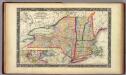
County Map Of The States Of New York, New Hampshire, Vermont. Massachusetts, Rhode Id. And Connecticut.
1 : 1900800 Mitchell, Samuel Augustus
Rome, Watertown and Ogdensburg Railroad.
1 : 5514850 Rome, Watertown & Ogdensburg Railroad Company
Map of the state of New-York and the surrounding country / by David H. Burr; engd. by Rawdon, Clark & Co., Albany, & Rawdon, Wright & Co., New York.; An atlas of the state of New York: containing a map of the state and of the several counties / by David H. Burr.
from An atlas of the state of New York : containing a map of the state and of the several counties / by David H. Burr. Burr, David H.; Rawdon, Clark & Co.; Rawdon, Wright & Co.; Stone & Clark Republishers,
Map of the state of New-York and the surrounding country / by David H. Burr; engd. by Rawdon, Clark & Co., Albany, & Rawdon, Wright & Co., New York.; An atlas of the state of New York, designed for the use of engineers, containing a map of the state and of the several counties. / Projected and drawn ... under the superintendence and direction of Simeon de Witt.
from An atlas of the state of New York, designed for the use of engineers, containing a map of the state and of the several counties. / Projected and drawn ... under the superintendence and direction of Simeon de Witt. Burr, David H.; De Witt, Simeon; Rawdon, Clark & Co.; Rawdon, Wright & Co.; Stone & Clark Republishers,
Map of the state of New-York and the surrounding country / by David H. Burr; engd. by Rawdon, Clark & Co., Albany, & Rawdon, Wright & Co., New York.; An atlas of the state of New York: containing a map of the state and of the several counties. / Projected and drawn under the superintendence and direction of Simeon de Witt ... And also the physical geography of the State ...
from An atlas of the state of New York : containing a map of the state and of the several counties. / Projected and drawn under the superintendence and direction of Simeon de Witt ... And also the physical geography of the State ... Burr, David H.; De Witt, Simeon,
An exact map of New England, New York, Pensylvania & New Jersey, from the latest surveys / J. Lodge, sculp.
from Parts
State of New York, Jany. 1, 1824: for Spafford's gazetteer.
from Whole Spafford,
A map of the provinces of New-York and New Jersey, with a part of Pennsylvania and the Province of Quebec
1 : 1040000 Sauthier, Claude Joseph Lotter, Matthäus Albrecht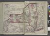
Railroads of the state.
from New topographical atlas and gazetteer of New York, comprising a topographical view of the several counties of the state, ... including ... map of the United States and territories ... Compiled from the latest astronomical observations, official surveys and records of the United States and territories ...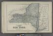
Plan of the State of New York.
from County atlas of Cayuga, New York. From recent and actual surveys and records under the superintendence of F. W. Beers.
New York.
1 : 1280000 Asher & Adams
A chorographical map of the province of New-York in North America, divided into counties, manors, patents and townships : exhibiting likewise all the private grants of land made and located in that Province / compiled from actual surveys deposited in the
from Whole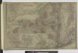
Oswego ; Buffalo ; Rochester ; Syracuse ; New York ; Albany ; Troy ; Vicinity of New York
from Atlas of Montgomery and Fulton counties, New York. From actual surveys / by and under the direction of B. Nichols ; assisted by H.B. Stranahan ... [et al.]
Neueste Karte von New York mit seinen Canaelen, Strassen, Eisenbahnen, Entfernungen der Hauptpunkte und Routen für Dampfschiffe
Grosser Hand-Atlas über alle Theile der Erde in 170 Karten Meyer, J. Verlag des Bibliographischen Instituts
Map of the meetings constituting New York Yearly Meeting of Friends.
from Whole
New York / W. Barker, sculp.; Carey's American pocket atlas; containing nineteen maps... with a brief description of each state.
from Carey's American pocket atlas; containing nineteen maps... with a brief description of each state. Carey, Mathew; Sweitzer, Henry,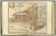
New-York State, surrounding country.
1 : 1300000 Burr, David H., 1803-1875
The state of New York
1 : 1317900 Lewis, Samuel Carey, Mathew
New York.
1 : 2500000 Finley, Anthony