Maps of Berkshire County

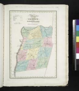
Map of the County of Rensselaer / by David H. Burr ; engd. by Rawdon, Clark & Co., Albany, & Rawdon, Wright & Co., New York.
from An atlas of the state of New York : containing a map of the state and of the several counties. / Projected and drawn under the superintendence and direction of Simeon de Witt ... And also the physical geography of the State ...
Map of the county of Rensselaer / by David H. Burr ; engd. by Rawdon, Clark & Co., Albany, & Rawdon, Wright & Co., New York.
from An atlas of the state of New York, designed for the use of engineers, containing a map of the state and of the several counties. / Projected and drawn ... under the superintendence and direction of Simeon de Witt.
Map of the counties of Albany and Schenectady / by David H. Burr ; engd. by Rawdon, Clark & Co., Albany, & Rawdon, Wright & Co., N.Y.
from An atlas of the state of New York : containing a map of the state and of the several counties. / Projected and drawn under the superintendence and direction of Simeon de Witt ... And also the physical geography of the State ...
Albany
1 : 100000
Albany
1 : 100000
Albany
1 : 100000
The Hudson by daylight map, from New York Bay to the head of tide water : containing names of streams, islands, and heights of mountains according to the latest coast survey : also the names of prominent residences, historic land marks, the old reaches o
from Hudson River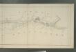
Map of the Hudson River Rail Road from New York to Albany / engraved by Robt. Haering, N.Y. ; W.C. Moore, del.
from Hudson River
Map of the county of Montgomery and Fulton / by David H. Burr; engd. by Rawdon, Clark & Co., Alby., & Rawdon, Wright & Co., N. York.; An atlas of the state of New York, designed for the use of engineers, containing a map of the state and of the several counties. / Projected and drawn ... under the superintendence and direction of Simeon de Witt.
from An atlas of the state of New York, designed for the use of engineers, containing a map of the state and of the several counties. / Projected and drawn ... under the superintendence and direction of Simeon de Witt. Burr, David H.; De Witt, Simeon; Rawdon, Clark & Co.; Rawdon, Wright & Co.; Stone & Clark Republishers,
Hudson River & vicinity / drawn by David H. Burr ; S. Stiles & Co., N.Y.
from Hudson River
Albany and vicinity, New York / Henry Gannett, chief topographer ; H.M. Wilson, geographer in charge ; triangulation by N.Y. State Survey and by U.S. Coast and Geodetic Survey ; topography by Frank Sutton and J.H. Jennings
1 : 62500 Annotatie geografische gegevens: Opname: 1891-1892 Henry Gannett 1846-1914; Wilson, H.M.; Sutton, Frank; Jennings, J.H.; N.Y. State Survey; US Coast and Geodetic Survey [Washington, D.C. : U.S. Geological Survey]
Map of the county of Berkshire, Massachusetts : based upon the trigonometrical survey of the state
1 : 50688 Walling, Henry Francis, 1825-1888 Smith, Gallup & Co.
Berkshire County.
1 : 158400 Gray, Ormando Willis; Walling, H. F.
Map of Albany County.
from New topographical atlas of the counties of Albany and Schenectady, New York : from actual surveys / by S.N. & D.G. Beers and assistants.
Rensselaer County.
1 : 151000 Burr, David H., 1803-1875
Taconic
1 : 125000
Taconic
1 : 125000
Taconic
1 : 125000
Taconic
1 : 125000
Hudson River & vicinity / drawn by David H. Burr ; S. Stiles & Co., N.Y.
from Hudson River
Albany - Troy - Schenectady and Vicinity (New York).
1 : 95040 Shell Oil Company
Berlin quadrangle, New York
1 : 62500 Geological Survey (U.S.) U.S. Geological Survey
Greylock quadrangle, Massachusetts
1 : 62500 Geological Survey (U.S.) U.S. Geological Survey
Becket quadrangle, Massachusetts
1 : 62500 Geological Survey (U.S.) U.S. Geological Survey
Watervliet [Township]; Watervliet Center [Village]; Watervliet Center Business Directory.; North Albany [Village]
from New topographical atlas of the counties of Albany and Schenectady, New York : from actual surveys / by S.N. & D.G. Beers and assistants.
Pittsfield quadrangle, Massachusetts
1 : 62500 Geological Survey (U.S.) U.S. Geological Survey
Plan of Bennington County, Vermont.
1 : 190080 H.W. Burgett and Company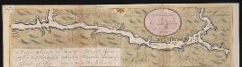
Nieuwe afteekeningh van de Noord Rivier met alle desselfs ancker plaetsen dieptens banken en klippen, geleegen in Nieuw Nederlandt [south part]
United States Gerard van Keulen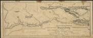
Map and profile of the Champlain Canal as made from Lake Champlain to the Hudson River and surveyed thence to the tide at Waterford
1 : 190080 Geddes, James