Maps of Suffolk County

Map of the county of Suffolk / by David H. Burr ; engd. by Rawdon Clark & Co., Albany, & Rawdon, Wright & Co., N. York.
from An atlas of the state of New York, designed for the use of engineers, containing a map of the state and of the several counties. / Projected and drawn ... under the superintendence and direction of Simeon de Witt.
Map of the county of Suffolk / by David H. Burr ; engd. by Rawdon Clark & Co., Albany, & Rawdon, Wright & Co., N. York.
from An atlas of the state of New York : containing a map of the state and of the several counties. / Projected and drawn under the superintendence and direction of Simeon de Witt ... And also the physical geography of the State ...
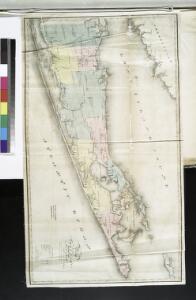
Map of the county of Suffolk / by David H. Burr ; engd. by Rawdon Clark & Co., Albany, & Rawdon, Wright & Co., N. York.
from An atlas of the state of New York : containing a map of the state and of the several counties / by David H. Burr.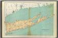
Suffolk County.
1 : 158400 Bien, Joseph Rudolf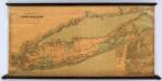
Colton's New Map Of Long Island.
1 : 126720 Colton, G.W.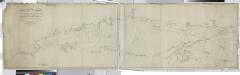
Long Island Sound from New York to Montock Point / surveyed in the years 1828, 29, & 30, by Edmund Blunt ; the writing by D.R. Harrison ; plan by W. Hooker ; W. Hooker, engraver & copper-plate printer, Franklin Hall, N.Y.
from Long Island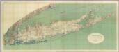
Map Of Long Island, New York.
1 : 125000 U.S. Geological Survey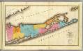
Suffolk County.
1 : 170000 Burr, David H., 1803-1875
Map of Long Island with the environs of New-York and the southern part of Connecticut / compiled from various surveys & documents by J. Calvin Smith ; engraved & printed by S. Stiles & Co., N. York.
From Long Island
Brooklyn land use policy
From The Borough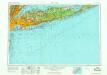
New York
1 : 250000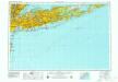
New York
1 : 250000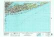
New York
1 : 250000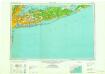
New York
1 : 250000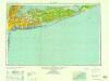
New York
1 : 250000
New York
1 : 250000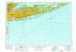
New York
1 : 250000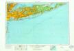
New York
1 : 250000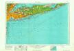
New York
1 : 250000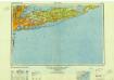
New York
1 : 250000
New York, Queens, Kings, Richmond counties.
1 : 158400 Burr, David H., 1803-1875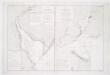
Carte de la baye et riviere de Délaware: contenant une éxacte et entiére description des rivages, criques, havres, sondes, bas-sonds, sables et les gissements des marques les plus considérables du pays depuis les Caps James et May jusqu̕à Philadelphie, suivant la carte originale, publiée en cette ville / par Josué Fischer; Depot de la marine.
from Charts and maps Josué Fischer,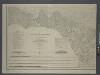
Map of New-York Bay and Harbor and the environs / founded upon a trigonometrical survey under the direction of F. R. Hassler, superintendent of the Survey of the Coast of the United States; triangulation by James Ferguson and Edmund Blunt, assistants; the hydrography under the direction of Thomas R. Gedney, lieutenant U.S. Navy; the topography by C. Renard and T.A. Jenkins assists.
from New York harbor Ferdinand R. Hassler; James Ferguson; Thomas R. Gedney; C. Renard; T.A. Jenkins,
Map of New-York Bay and Harbor and the environs / founded upon a trigonometrical survey under the direction of F.R. Hassler, superintendent of the Survey of the Coast of the United States; triangulation by James Ferguson and Edmund Blunt assistants; the hydrography under the direction of Thomas R. Gedney, lieutenant U.S. Navy; the topography by C. Renard and T.A. Jenkins assists.; verified by C.M. Eakin, assistant.
from New York harbor Ferdinand R. Hassler; James Ferguson; Thomas R. Gedney; C. Renard; T.A. Jenkins; C.M. Eakin,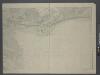