Maps of Suffolk County
Suffolk County.
1 : 158400 Bien, Joseph Rudolf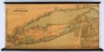
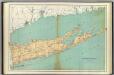
Colton's New Map Of Long Island.
1 : 126720 Colton, G.W.
Map of the county of Suffolk / by David H. Burr ; engd. by Rawdon Clark & Co., Albany, & Rawdon, Wright & Co., N. York.
from An atlas of the state of New York, designed for the use of engineers, containing a map of the state and of the several counties. / Projected and drawn ... under the superintendence and direction of Simeon de Witt.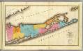
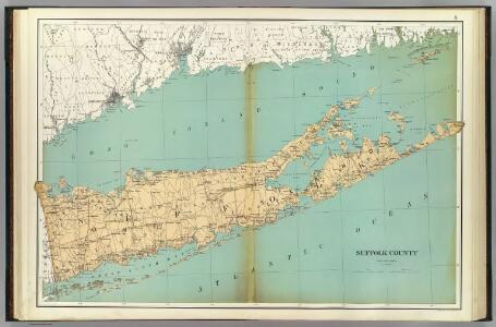
Suffolk County.
1 : 170000 Burr, David H., 1803-1875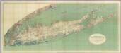
Map Of Long Island, New York.
1 : 125000 U.S. Geological Survey
Map of Long Island with the environs of New-York and the southern part of Connecticut / compiled from various surveys & documents by J. Calvin Smith ; engraved & printed by S. Stiles & Co., N. York.
From Long Island
Map of the county of Westchester / by David H. Burr; engd. by Rawdon, Clark & Co., Albany, & Rawdon, Wright & Co., New York.; An atlas of the state of New York: containing a map of the state and of the several counties / by David H. Burr.
from An atlas of the state of New York : containing a map of the state and of the several counties / by David H. Burr. Burr, David H.; Rawdon, Clark & Co.; Rawdon, Wright & Co.; Stone & Clark Republishers,
Map of the county of Westchester / by David H. Burr; engd. by Rawdon, Clark & Co., Albany, & Rawdon, Wright & Co., New York.; An atlas of the state of New York, designed for the use of engineers, containing a map of the state and of the several counties. / Projected and drawn ... under the superintendence and direction of Simeon de Witt.
from An atlas of the state of New York, designed for the use of engineers, containing a map of the state and of the several counties. / Projected and drawn ... under the superintendence and direction of Simeon de Witt. Burr, David H.; De Witt, Simeon; Rawdon, Clark & Co.; Rawdon, Wright & Co.; Stone & Clark Republishers,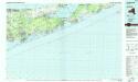
Long Island East
1 : 100000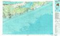
Long Island East
1 : 100000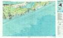
Long Island East
1 : 100000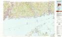
New Haven
1 : 100000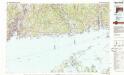
New Haven
1 : 100000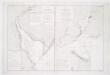
Carte de la baye et riviere de Délaware: contenant une éxacte et entiére description des rivages, criques, havres, sondes, bas-sonds, sables et les gissements des marques les plus considérables du pays depuis les Caps James et May jusqu̕à Philadelphie, suivant la carte originale, publiée en cette ville / par Josué Fischer; Depot de la marine.
from Charts and maps Josué Fischer,
Map of the counties of Orange and Rockland / by David H. Burr; engd. by Rawdon, Clark & Co., Albany, & Rawdon, Wright & Co., N. York.; An atlas of the state of New York: containing a map of the state and of the several counties. / Projected and drawn under the superintendence and direction of Simeon de Witt ... And also the physical geography of the State ...
from An atlas of the state of New York : containing a map of the state and of the several counties. / Projected and drawn under the superintendence and direction of Simeon de Witt ... And also the physical geography of the State ... Burr, David H.; De Witt, Simeon,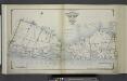
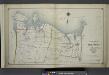
Index Map No. 1 of a part of Suffolk County. South Side - Ocean Shore, Long Island. Southampton. Published by E. Belcher Hyde. 97 Liberty Street, Brooklyn. 5 Beekman Street, Manhattan. 1916. Volume Two.
from Atlas of ... Suffolk County, Long Island, New York ... : based upon actual measurements by our own corps of engineers, maps on file at county offices, also maps from actual surveys furnished by individual owners / under the supervision of Merritt B. Hyde.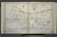
Index Map No.2 of a part of Suffolk County. South Side - Ocean Shore, Long Island. Part of Islip and Part of Brookhaven. Published by E. Belcher Hyde. 97 Liberty Street, Brooklyn. 5 Beekman Street, Manhattan. 1915. Volume One.
from Atlas of ... Suffolk County, Long Island, New York ... : based upon actual measurements by our own corps of engineers, maps on file at county offices, also maps from actual surveys furnished by individual owners / under the supervision of Merritt B. Hyde.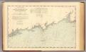
Norwalk Is.-SW Ledge.
1 : 80000 United States Coast Survey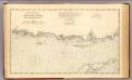
SW Ledge-Niantic Bay.
1 : 80000 United States Coast Survey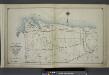
Index Map No. 2 of a part of Suffolk County. North Side - Sound Shore, Long Island. Brookhaven. Published by E. Belcher Hyde. 97 Liberty Street, Brooklyn. 5 Beekman Street, Manhattan. 1917. Volume One.
from Atlas of ... Suffolk County, Long Island, New York ... : based upon actual measurements by our own corps of engineers, maps on file at county offices, also maps from actual surveys furnished by individual owners / under the supervision of Merritt B. Hyde.
Southold and Shelter Island, Suffolk Co. L.I. - Village, North of Greensport, Town of Southold, Suffolk Co. - Part of Town of Southold.
from Atlas of Long Island, New York. From recent and actual surveys and records.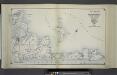
Index Map No. 2 of a part of Suffolk County. South Side - Ocean Shore, Long Island. Easthampton. Published by E. Belcher Hyde. 97 Liberty Street, Brooklyn. 5 Beekman Street, Manhattan. 1916. Volume Two.
from Atlas of ... Suffolk County, Long Island, New York ... : based upon actual measurements by our own corps of engineers, maps on file at county offices, also maps from actual surveys furnished by individual owners / under the supervision of Merritt B. Hyde.
Islip
1 : 125000
Islip
1 : 125000
Islip
1 : 125000
Islip
1 : 125000
Islip
1 : 125000
Islip
1 : 125000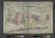
Part of Brookhaven, Suffolk Co.
from Atlas of Long Island, New York. From recent and actual surveys and records.