Maps of Long Island
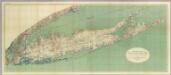
Map Of Long Island, New York.
1 : 125000 U.S. Geological Survey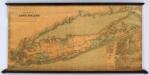
Colton's New Map Of Long Island.
1 : 126720 Colton, G.W.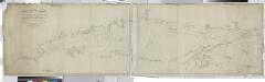
Long Island Sound from New York to Montock Point / surveyed in the years 1828, 29, & 30, by Edmund Blunt ; the writing by D.R. Harrison ; plan by W. Hooker ; W. Hooker, engraver & copper-plate printer, Franklin Hall, N.Y.
from Long Island
Map of the county of Suffolk / by David H. Burr ; engd. by Rawdon Clark & Co., Albany, & Rawdon, Wright & Co., N. York.
from An atlas of the state of New York : containing a map of the state and of the several counties / by David H. Burr.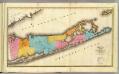
Suffolk County.
1 : 170000 Burr, David H., 1803-1875
Brooklyn land use policy
From The Borough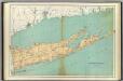
Suffolk County.
1 : 158400 Bien, Joseph Rudolf
Map of the county of Suffolk / by David H. Burr ; engd. by Rawdon Clark & Co., Albany, & Rawdon, Wright & Co., N. York.
from An atlas of the state of New York, designed for the use of engineers, containing a map of the state and of the several counties. / Projected and drawn ... under the superintendence and direction of Simeon de Witt.
New York, Queens, Kings, Richmond counties.
1 : 158400 Burr, David H., 1803-1875
Map of enlarged city of Brooklyn, from official records and surveys.
From Brooklyn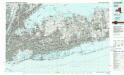
Long Island West
1 : 100000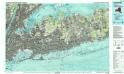
Long Island West
1 : 100000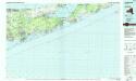
Long Island East
1 : 100000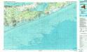
Long Island East
1 : 100000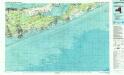
Long Island East
1 : 100000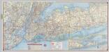
Shell Metropolitan New York and Long Island. Eastern Long Island.
1 : 126720 Shell Oil Company
[A chart of New York Island & North River, East River, passage through Hell Gate, Flushing Bay, Hampstead Bay, Oyster Bay, Huntington Bay, Cow Harbour, East Chester Inlet, Rochelle, Rye, Patrick Islands, &c.]
from Charts and maps
Greater New York's census districts, 1920 : compiled from map prepared 1915-1918 for the 1920 census by the New York Federation of Churches.
From Manhattan
Map of the county of Westchester / by David H. Burr; engd. by Rawdon, Clark & Co., Albany, & Rawdon, Wright & Co., New York.; An atlas of the state of New York: containing a map of the state and of the several counties / by David H. Burr.
from An atlas of the state of New York : containing a map of the state and of the several counties / by David H. Burr. Burr, David H.; Rawdon, Clark & Co.; Rawdon, Wright & Co.; Stone & Clark Republishers,
Map of the county of Westchester / by David H. Burr; engd. by Rawdon, Clark & Co., Albany, & Rawdon, Wright & Co., New York.; An atlas of the state of New York, designed for the use of engineers, containing a map of the state and of the several counties. / Projected and drawn ... under the superintendence and direction of Simeon de Witt.
from An atlas of the state of New York, designed for the use of engineers, containing a map of the state and of the several counties. / Projected and drawn ... under the superintendence and direction of Simeon de Witt. Burr, David H.; De Witt, Simeon; Rawdon, Clark & Co.; Rawdon, Wright & Co.; Stone & Clark Republishers,
Cortlandt Manor map : prepared expressly for this work / copied for Piere Van Cortlandt esqr., June 1774, by G. Baneker.
from Cities and towns, A-Z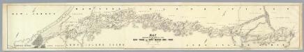
Map Exhibiting The ... Lines for the New-York and New-Haven Rail-Road.
1 : 40000 Anderson, P.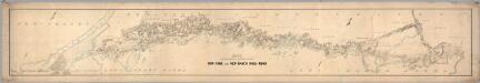
Map Exhibiting The ... Lines for the New-York and New-Haven Rail-Road.
1 : 20000 Anderson, P.
Carte de la baye et riviere de Délaware: contenant une éxacte et entiére description des rivages, criques, havres, sondes, bas-sonds, sables et les gissements des marques les plus considérables du pays depuis les Caps James et May jusqu̕à Philadelphie, suivant la carte originale, publiée en cette ville / par Josué Fischer; Depot de la marine.
from Charts and maps Josué Fischer,
Map of the City of Brooklyn as consolidated by an act of the Legislature of the Ste of New York . . . Constructed from the official maps of the Commissioners . . . Exhibiting the farm lines names of the original owners.
From Brooklyn
United States--east coast, New York--New Jersey, New York Harbor / Coast Survey.
United States Coast Survey,
Westchester Co. & surroundings.
1 : 253440 Bien, Joseph Rudolf
A chart of New York Harbour: with the banks, soundings and sailing marks from the most accurate surveys & observations.
from Charts and maps Printed for Mount and Page?: [London]; Jno. Mount and Tho. Page,
Index Map No. 1 of a part of Suffolk County. South Side - Ocean Shore, Long Island. Southampton. Published by E. Belcher Hyde. 97 Liberty Street, Brooklyn. 5 Beekman Street, Manhattan. 1916. Volume Two.
from Atlas of ... Suffolk County, Long Island, New York ... : based upon actual measurements by our own corps of engineers, maps on file at county offices, also maps from actual surveys furnished by individual owners / under the supervision of Merritt B. Hyde.
Topographical map of New York City, County and vicinity: showing old farm lines &c. / based on Randells and other official surveys, drawings and modern surveys by J.F. Harrison & T. Magrane; printed by C. Wadlow.
from (A-Z) J. F. Harrison; T. Magrane; C. Wadlow,


