Maps of Weehawken

Map of Newtown Creek and vicinity [and factories nearby.]
From Brooklyn
Fire department of the city of Brooklyn.
From Brooklyn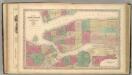
New York (City).
1 : 20600 Colton, G.W.
Map of New York City, south of 46th St.
From Manhattan
Map of the city of Brooklyn, as laid out by commissioners, and confirmed by acts of the Legislature of the state of New York : made from actual surveys, the farm lines and names of original owners, being accurately drawn from authentic sources, contai...
From Brooklyn
Williamsburg, Greenpoint. (cont.)
From District 1
Plan of the city of New York and of the island : as laid out by the commissioners, altered and arranged to the present time / engraved by J.F. Morin.
from Manhattan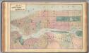
New York, Brooklyn.
1 : 21000 Beers, F. W. (Frederick W.)
Brooklyn
1 : 24000
Brooklyn
1 : 24000
Brooklyn
1 : 24000
Brooklyn
1 : 24000
Brooklyn
1 : 24000
Brooklyn
1 : 24000
Brooklyn
1 : 24000
Brooklyn
1 : 24000
Hagstrom's Map of lower New York City, House Number and Subway Guide.
From Manhattan
The Great metropolis in 1804.
from Manhattan
New York.
from Manhattan
New map of the city of New York.
from Manhattan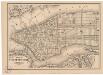
Map of the city of New York
1 mapa. Datat a partir de 1900 aproximadament. D. Appleton & Co.
Map of the city of New York : with street directory showing house-numbers, hotels, churches, banks, theatres, ferries, house-car, steam and elevated R.R'ds, &c
1 : 12670 Dripps, M. (Matthew) M. Dripps
Maspeth, Sunnyside, Woodside. (cont.)
From District 2
Plan of the city of Brooklyn...East New York, with part of Long Island City and Flatbush.
From Brooklyn
Map and plan showing the street system in the 1st ward of the borough of Queens, formerly Long Island City.
From Queens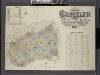
Insurance Maps of the Brooklyn city of New York Volume Four. Published by the Sanborn map co. 117, Broadway, New York. 1887.
From Atlas 74. Vol. 4, 1887.
Liqordom in New York City.
From Manhattan
New York City and the Adjacent Cities.
1 : 20000 Colton, G.W.
Map of the local boundaries of the Protestant Episcopal Churches of the city of New York.
from Manhattan
![Map of Newtown Creek and vicinity [and factories nearby.]](https://images-2.georeferencer.com/images/iiif/966347931865/full/,300/0/native.jpg)

