Maps of Ticino
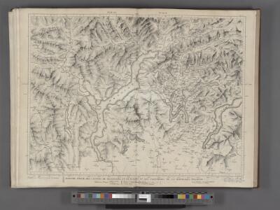
Majeure partie des Cantons de Bellinzona et de Lugano et les frontieres de la Republique Italienne.
From Atlas Suisse. Levé et dessiné par J. H. Weiss aux fraix de J. R. Meyer á Aarau dans les années 1786 á 1802. Gravée par Guerin, Eichler, et Scheurmann.

PARTE ALPESTRE | DELLO STATO DI | MILANO, | Con il LAGO MAGGIORE | DI LUGANO, É DI COMO
[Amsterdam : Joan Blaeu]
Parte Alpestre Dello Stato Di Milano, Con il Lago Maggiore Di Lugano, É Di Como [Karte], in: Theatrum orbis terrarum, sive, Atlas novus, Bd. 3, S. 61.
1 Karte aus Atlas Blaeu, Joan Blaeu, Willem Janszoon
Parte Alpestre Dello Stato Di Milano, Con il Lago Maggiore Di Lugano, È Di Como [Karte], in: Novus Atlas, das ist, Weltbeschreibung, Bd. 3, S. 73.
1 Karte aus Atlas Blaeu, Joan Blaeu, Willem Janszoon
Nova Rhaetiae atque totius Helvetiae descriptio
1 : 350000 1 Karte auf 10 Bl. per Aegidium Tschudum Glaronensem Hofer & Burger, Zürich
Atlas Suisse
1 : 120000 16 Karten levé et dessiné par J.H. Weiss [et Joachim Eugen Müller] aux frais de J.R. Meyer à Aarau dans les années 1786 à 1802 ; gravée [sic] par [Christophe] Guérin, [Matthias Gottfried] Eichler et [Johann Jakob] Scheurmann [Johann Rudolf Meyer], Aarau
<<Der>> Canton Ticino
1 : 350000 1 Karte gezeichnet v. H. Keller nach Paolo Ghiringelli ; gest. von J.J. Scheurmann [Orell Füssli & Comp.], [Zürich]
Parte Alpestre dello Stato di Milano
1 : 340000 Mollova mapová sbírka Valk, Gerhard Schenk, Peter I
Wandkarte der Schweiz
1 : 200000 1 Karte auf 8 Blättern J.M. Ziegler Wurster, Winterthur
Atlas der Schweiz
1 : 450000 1 Atlas (18 Bl.) gez. u. gest. v. J. Scheurmann Orell Fussli, Zurich
Ticino
1 : 1450000 [Stumme Kartenskizzen der ganzen Schweiz und der einzelnen Kantone zu Unterrichtszwecken] Schulbuchhandlung Antenen
Atlas de la Suisse
1 : 450000 1 Atlas (19 Bl.) dessiné par MM. H. Keller, Scheurmann, Pfyffer d'Altishofen, Osterwald, etc. ; gravé par M. Scheurmann Orell Füssli & Co., Zürich
<<Die>> Oberitalienischen Seen und ihr Excursionsgebiet
1 : 150000 1 Karte von F. Becker ; Stich der topogr. Anstalt J. Schlumpf, Winterthur Alfred Arnold, Lugano
Viaggio ai tre laghi
1 : 188000 Stucchi
Carte de la Suisse avec les plans des cheflieux des 22 cantons
1 : 200000 1 Karte auf 8 Bl. dessinée et publié par Henri Keller ; Lithogr. von J. Schweizer = Charte der Schweiz mit den Grundrissen der Hauptorte der 22 Cantone Keller, Zürich
<<Der>> Canton Ticino
1 : 350000 1 Karte gezeichnet v. H. Keller nach Paolo Ghiringelli ; gest. von J.J. Scheurmann Orell, Füssli & Cp., Zürich
<<Der>> Canton Ticino
1 : 350000 1 Karte gezeichnet v. H. Keller nach Paolo Ghiringelli ; gest. von J.J. Scheurmann Orell, Füssli & Cp., Zürich
<<Der>> Canton Ticino
1 : 350000 1 Karte gezeichnet v. H. Keller nach Paolo Ghiringelli ; gest. von J.J. Scheurmann Orell Füssli & Cp., Zürich
Carta geologica delle provinicie Lombarde
1 : 172800 Westblatt Curioni, G. Hoepli
Carta del Cantone di Ticino
1 : 250000 1 Karte disegto da E. Keller & C. Hardmeier, Lit. da Grimminger Huber & Co., S. Gallo
Carta del cantone di Ticino
1 : 250000 1 Karte disegto da E. Keller & C. Hardmeier ; Lith. da Grimminger [Verlag nicht ermittelbar], [Erscheinungsort nicht ermittelbar]
Distanzenkarte von der Schweiz
1 : 200000 1 Karte in 8 Teilen nach den besten Hülfsquellen bearb. von R. Huber Wagner, Bern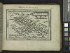
The Lake of Como.
from Abraham Ortelius his epitome of the theater of the worlde / nowe latlye ... renewed and augmented ... by Micheal Coignet, mathematitian of Antwarpe.
Carta di viaggio da Milano ai tre laghi Maggiore di Lugano e di Como e nelle loro vicinanze
1 : 170000 Como, jezero (Itálie)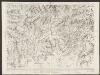
Majeure partie des cantons de Bellinzona et de Lugano et les frontières de la République Italienne
1 : 108000 Weiss, Johann Heinrich ; Guérin, Christophe ; Meyer, Johann Rudolf J. R. Meyer
Oberitalienischen Seen und ihr Excursionsgebiet
1 : 150000 Becker, Fridolin Alfred Arnold

Stehende Gewässer
Atlas der Hydrographie Berghaus, Hermann Justus Perthes