Maps of Varese

Atlas Suisse
1 : 120000 16 Karten levé et dessiné par J.H. Weiss [et Joachim Eugen Müller] aux frais de J.R. Meyer à Aarau dans les années 1786 à 1802 ; gravée [sic] par [Christophe] Guérin, [Matthias Gottfried] Eichler et [Johann Jakob] Scheurmann [Johann Rudolf Meyer], Aarau
Majeure partie des Cantons de Bellinzona et de Lugano et les frontieres de la Republique Italienne.
From Atlas Suisse. Levé et dessiné par J. H. Weiss aux fraix de J. R. Meyer á Aarau dans les années 1786 á 1802. Gravée par Guerin, Eichler, et Scheurmann.
Parte Alpestre dello Stato di Milano
1 : 340000 Mollova mapová sbírka Valk, Gerhard Schenk, Peter I
Viaggio ai tre laghi
1 : 188000 Stucchi
<<Die>> Oberitalienischen Seen und ihr Excursionsgebiet
1 : 150000 1 Karte von F. Becker ; Stich der topogr. Anstalt J. Schlumpf, Winterthur Alfred Arnold, Lugano
Majeure partie des cantons de Bellinzona et de Lugano et les frontières de la République Italienne
1 : 108000 Weiss, Johann Heinrich ; Guérin, Christophe ; Meyer, Johann Rudolf J. R. Meyer
Ticino
1 : 1450000 [Stumme Kartenskizzen der ganzen Schweiz und der einzelnen Kantone zu Unterrichtszwecken] Schulbuchhandlung Antenen
Oberitalienischen Seen und ihr Excursionsgebiet
1 : 150000 Becker, Fridolin Alfred Arnold
Carta di viaggio da Milano ai tre laghi Maggiore di Lugano e di Como e nelle loro vicinanze
1 : 170000 Como, jezero (Itálie)
<<Der>> Canton Ticino
1 : 350000 1 Karte gezeichnet v. H. Keller nach Paolo Ghiringelli ; gest. von J.J. Scheurmann Orell, Füssli & Cp., Zürich
<<Der>> Canton Ticino
1 : 350000 1 Karte gezeichnet v. H. Keller nach Paolo Ghiringelli ; gest. von J.J. Scheurmann Orell, Füssli & Cp., Zürich
Distanzenkarte von der Schweiz
1 : 200000 1 Karte in 8 Teilen nach den besten Hülfsquellen bearb. von R. Huber Wagner, Bern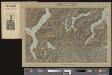
Lugano
1 Vogelschaukarte Orell Füssli, Zürich
Stehende Gewässer
Atlas der Hydrographie Berghaus, Hermann Justus Perthes
Nuova carta topografica dei tre laghi Maggiore, di Lugano e di Como
1 : 180000 Como, jezero (Itálie) Ostinelli, Carlo Antonio C. A. Ostinelli
Biella
1 : 200000 Herder, Bartholomew

<<Die>> schweizerischen Landvogteyen Lauis und Mendris nebst den Grentzen von Bellenz, Luggaris und mayländischen Gebiet
1 : 90000 1 Karte dessta di G. Conr. Finsler ; gravé par [Jakob Joseph] Clausner [Ludwig von Meiss], [Erscheinungsort nicht ermittelbar]
Generalkarte der Gotthardbahn
1 : 100000 Südblatt im Verlag von Orell Füssli & Co.
Carta del Cantone di Ticino
1 : 250000 Keller, Heinrich ; Hardmeier, C. ; Grimminger, Adolf Enrico Füssli & Co.
Canton Ticino
1 : 350000 Keller, Heinrich ; Scheuermann, Johann Jakob Orell, Füssli & Cp.
Rete trigonometrical del Cantone Ticino
1 : 250000 Ufficio topografico federale
[Lago Maggiore und Umgebung]
1 : 250000 Alpy italské (pohoří) Wagner & Debes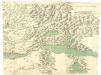
Carta dello Stato di Milano e Piemonte
Mollova mapová sbírka
Carta del cantone di Ticino
1 : 150000 Ziegler, Jakob Melchior Stich, Druck u. Verlag v. J. Wurster u. Comp.
Carta del cantone di Ticino
1 : 150000 1 Karte J.M. Ziegler ; Gebirgsstich v. R. Leuzinger ; Schrift von P. Steiner Stich, Druck u. Verlag v. J. Wurster u. Comp., Winterthur
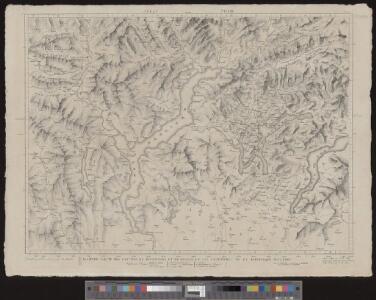
Blatt XXIV: Lugano, Como, uit: Topographische Karte der Schweiz / vermessen und hrsg. ... unter Aufsicht des Generals G.H. Dufour
1 : 100000 Annotatie: Met plaatsnamenregister (bl. V), bladwijzer (bl. XXI) en hoogteregister (bl. XXV); Voor aanwezige bladen zie overzichtsblad Dufour, G. H. [Bern : Eidg. Topogr. Bureau]
Topographische Karte der Schweiz
1 : 100000 25 Karten vermessen und hrsg. auf Befehl der Eidgenössischen Behörden ; aufgenommen unter der Aufsicht des Generals G.H. Dufour Eidg. Topographisches Bureau, [Genève], [später: Bern]
[Comer See und Umgebung]
1 : 256000 Alpy italské (pohoří)