Maps of Kings County
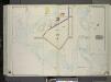
Brooklyn, Vol. 3, Double Page Plate No. 37; Part of Ward 32, Section 25; [Map bounded by Avenue U, E. 68th St., Avenue Z; Including Bushes Meadow, Ryder St., Avenue X] / by and under the direction of Hugo Ullitz.
From Volume 3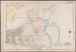
Plate 31: [Bounded by Avenue V., Knapp Street, Avenue W., E. 30th Street, Avenue X., Gerristen Avenue, Avenue W., Knapp Street, Avenue V., Bragg Street, (Sheepstead Bay) Emmons Avenue, Ocean Avenue and Neck Road.]; Atlas of the borough of Brooklyn, city of New York: from actual surveys and official plans by George W. and Walter S. Bromley.
from Atlas of the borough of Brooklyn, city of New York : from actual surveys and official plans by George W. and Walter S. Bromley. G.W. Bromley & Co.,
Brooklyn V. 15, Plate No. 121 [Map bounded by Avenue X, Jamaica Bay, E.74th St.]
From Atlas 101. Vol. 15, 1907.
Plate 26: [Bounded by Avenue L. Ralph Avenue, E. 61st Street, Avenue U, Ryder Street, Avenue W, E. 33rd Street, Avenue V, Burnett Street, Avenue U, Gerritsen Avenue, Avenue U and Ocean Avenue.]
from Robinson's atlas of Kings County, New York : compiled from official records ... / under the direction of E. Robinson.
23D - N.Y. City (Aerial Set).
from Sectional aerial maps of the City of New York / [photographed and assembled under the direction of the chief engineer, July 1st, 1924].
29B - N.Y. City (Aerial Set).
from Sectional aerial maps of the City of New York / [photographed and assembled under the direction of the chief engineer, July 1st, 1924].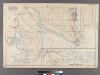
Plate 31: [Bounded by Avenue K, E. 103rd Street, Avenue N, E. 98th Street, (Bulkhead Line) Denton Avenue, (Paerdegat Basin) Paerdegat Avenue, E. 76th Street, Avenue Y, (Bulkhead Line) E. 69th Street, Avenue T and Ralph Avenue.]
from Robinson's atlas of Kings County, New York : compiled from official records ... / under the direction of E. Robinson.
23C - N.Y. City (Aerial Set).
from Sectional aerial maps of the City of New York / [photographed and assembled under the direction of the chief engineer, July 1st, 1924].
29A - N.Y. City (Aerial Set).
from Sectional aerial maps of the City of New York / [photographed and assembled under the direction of the chief engineer, July 1st, 1924].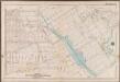
Plate 32: [Bounded by Avenue P., E. 31st Street, Avenue Q., E. 34th Street, Avenue R., Kimball Street, Fillmore Avenue, E. 55th Street, Lay Avenue, Flatbush Avenue, Avenue U., Ryder Street, Avenue X., E. 30th Street, Avenue W., Knapp Street, Avenue V. and Ocean Avenue.]; Atlas of the borough of Brooklyn, city of New York: from actual surveys and official plans by George W. and Walter S. Bromley.
from Atlas of the borough of Brooklyn, city of New York : from actual surveys and official plans by George W. and Walter S. Bromley. G.W. Bromley & Co.,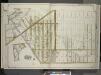
Brooklyn, Vol. 3, Double Page Plate No. 4; Part of Ward 32, Section 23; [Map bounded by Avenue K, Ralph Ave., Avenue O, Flatbush Ave.; Including Flatlands Ave., E. 37th St., Avenue E, E. 38th St., Hubbard PL., E. 40th St.]; Sub Plan; [Map bounded by A...
From Volume 3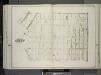
Brooklyn, Vol. 3, Double Page Plate No. 24; Part of Wards 31-32, Sections 23-24; [Map bounded by Flatlands Ave., Flatbush Ave., Fillmore Ave.; Including Burnett St., Avenue P, E. 27th St.] / by and under the direction of Hugo Ullitz.
From Volume 3
Plate 38: [Bounded by Avenue K., Ralph Avenue, Avenue K., E. 70th Street, Avenue L., E. 75th Street, Avenue M., Skidmore Avenue, E. 83rd Street, Denton Avenue, E. 80th Street, [...] Avenue N., E. 76th Street, Avenue Y., E. 69th Street, Avenue T., E. 65th Street, Avenue U., E. 54th Street, Avenue T. and E. 55th Street.]; Atlas of the borough of Brooklyn, city of New York: from actual surveys and official plans by George W. and Walter S. Bromley.
from Atlas of the borough of Brooklyn, city of New York : from actual surveys and official plans by George W. and Walter S. Bromley. G.W. Bromley & Co.,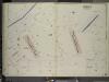
Brooklyn, Vol. 7, Double Page Plate No. 42; Part of Ward 31, Section 22; [Map bounded by Gerritsens Creek, Avenue X; Including Bragg St., Avenue U]; Sub Plan No. 1; [Map bounded by Avenue U, Burnett St.]; Sub Plan No. 2; [Map bounded by Gerritsens C
from Ward 31.
Brooklyn, Vol. 7, Double Page Plate No. 43; Part of Ward 31, Section 22; [Map bounded by Shell Bank Creek, Hog Point Creek; Including Sheepshead Bay, Ford St., Avenue Y]; Sub Plan; [Map bounded by Cerritsens Creek, Sheepshead Bay, B
from Ward 31.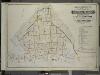
Index to Volume Seven. Atlas of the Borough of Brooklyn. Sections 20, 21 & 22. Ward 31. City of New York. E. Belcher Hyde, 97 Liberty St., Brooklyn Borough. 1907.
from Ward 31.
Flatlands. Kings Co. L.I.
From Atlas of Long Island, New York. From recent and actual surveys and records.
Coney Island
1 : 24000
Coney Island
1 : 24000
Coney Island
1 : 24000
Coney Island
1 : 24000
Coney Island
1 : 24000
Coney Island
1 : 24000
Coney Island
1 : 24000
Flatlands. Kings Co. L.I.
from Atlas of Long Island, New York. From recent and actual surveys and records.
Hammods Atlas of New York City and the metropolitan district

East Astoria, part of Long Island City, Queens Co.
from Atlas of Long Island, New York. From recent and actual surveys and records.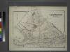
Gravesend. Kings Co. L.I.
from Atlas of Long Island, New York. From recent and actual surveys and records.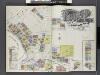
Insurance Maps of Brooklyn New York Sanborn Perris map co. 113 Broadway, New York. Volume "B" 1895.
From Atlas 62. Vol. B, 1895.
![Brooklyn, Vol. 3, Double Page Plate No. 37; Part of Ward 32, Section 25; [Map bounded by Avenue U, E. 68th St., Avenue Z; Including Bushes Meadow, Ryder St., Avenue X] / by and under the direction of Hugo Ullitz.](https://images-3.georeferencer.com/images/iiif/017426157670/full/,300/0/native.jpg)

