Maps of Kings County

Brooklyn V. 15, Plate No. 121 [Map bounded by Avenue X, Jamaica Bay, E.74th St.]
From Atlas 101. Vol. 15, 1907.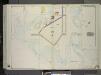
Brooklyn, Vol. 3, Double Page Plate No. 37; Part of Ward 32, Section 25; [Map bounded by Avenue U, E. 68th St., Avenue Z; Including Bushes Meadow, Ryder St., Avenue X] / by and under the direction of Hugo Ullitz.
From Volume 3
23D - N.Y. City (Aerial Set).
from Sectional aerial maps of the City of New York / [photographed and assembled under the direction of the chief engineer, July 1st, 1924].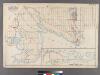
Plate 31: [Bounded by Avenue K, E. 103rd Street, Avenue N, E. 98th Street, (Bulkhead Line) Denton Avenue, (Paerdegat Basin) Paerdegat Avenue, E. 76th Street, Avenue Y, (Bulkhead Line) E. 69th Street, Avenue T and Ralph Avenue.]
from Robinson's atlas of Kings County, New York : compiled from official records ... / under the direction of E. Robinson.
Area District Map Section No. 23; Area district map / City of New York, Board of Estimate and Apportionment.
from Area district map / City of New York, Board of Estimate and Apportionment. New York (N.Y.). Board of Estimate and Apportionment,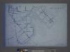
Use District Map Section No. 23; Use district map / City of New York, Board of Estimate and Apportionment.
from Use district map / City of New York, Board of Estimate and Apportionment. New York (N.Y.). Board of Estimate and Apportionment,
Height District Map Section No. 23; Height district map / City of New York, Board of Estimate and Apportionment.
from Height district map / City of New York, Board of Estimate and Apportionment. New York (N.Y.). Board of Estimate and Apportionment,
Spring Creek -- Linear City. (cont.)
From Spring Creek -- Linear City
Index to Volume Seven. Atlas of the Borough of Brooklyn. Sections 20, 21 & 22. Ward 31. City of New York. E. Belcher Hyde, 97 Liberty St., Brooklyn Borough. 1907.
from Ward 31.
Flatlands. Kings Co. L.I.
From Atlas of Long Island, New York. From recent and actual surveys and records.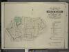
Index to Volume Five. Atlas of the Borough of Brooklyn. Sections 15 & 16. Ward 29 and part of 32. City of New York. E. Belcher Hyde, 97 Liberty St., Brooklyn Borough. 1906.
from Ward 29 and part of 32.
Coney Island
1 : 24000
Coney Island
1 : 24000
Coney Island
1 : 24000
Coney Island
1 : 24000
Coney Island
1 : 24000
Coney Island
1 : 24000
Coney Island
1 : 24000
Flatlands. Kings Co. L.I.
from Atlas of Long Island, New York. From recent and actual surveys and records.
Index to Volume Four. Atlas of the Borough of Brooklyn. Sections 12, 13 & 14. Wards 26 and part of 29 & 32. City of New York. E. Belcher Hyde, 97 Liberty St., Brooklyn Borough. 1904.
from Wards 26 and part of 29 & 32.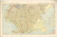
Hammods Atlas of New York City and the metropolitan district

New Lots. Kings Co. L.I.
from Atlas of Long Island, New York. From recent and actual surveys and records.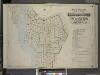
Index to Volume One, Atlas of the Borough of Brooklyn Sections 1, 2, 3 & 4. Wards 1, 2, 3, 4, 5, 6, 8, 9, 10, 12 & 22. City of New York. Published by E. Belcher Hyde, 97 Liberty St., Brooklyn. 1903.
from Wards 1, 2, 3, 4, 5, 6, 8, 9, 10, 12 & 22.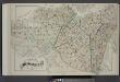
Index Map of Brooklyn
from Detailed estate and old farm line atlas of the city of Brooklyn : complete in six volumes ... from official records, private plans, and actual surveys ... / by G.M. Hopkins, C.E.
Map of Staten Island, Richmond County, New York City, from surveys under the direction of H. F. Walling.
From Staten Island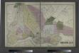
The City of Brooklyn.
from Atlas of Long Island, New York. From recent and actual surveys and records.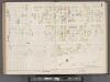
Hudson County, V. 8, Double Page Plate No. 1 [Map bounded by Spring St., Cortland St., Hillside Rd., Paterson Plank Rd.] / surveyed and published by Chas. B. Brush. Vol. 8.
From Insurance maps of Hudson County, New Jersey
Index Map to Volume Two. Atlas of the Brooklyn Borough of the City of New York.
from Atlas of the Brooklyn borough of the City of New York : originally Kings Co.; complete in three volumes ... based upon official maps and plans ... / by and under the supervision of Hugo Ullitz, C.E.
Brooklyn.
1 : 31000 Rand McNally and Company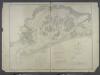
![Brooklyn V. 15, Plate No. 121 [Map bounded by Avenue X, Jamaica Bay, E.74th St.]](https://images-2.georeferencer.com/images/iiif/867771879970/full/,300/0/native.jpg)

