Maps of Kings County
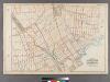
Plate 26: [Bounded by Avenue L. Ralph Avenue, E. 61st Street, Avenue U, Ryder Street, Avenue W, E. 33rd Street, Avenue V, Burnett Street, Avenue U, Gerritsen Avenue, Avenue U and Ocean Avenue.]
from Robinson's atlas of Kings County, New York : compiled from official records ... / under the direction of E. Robinson.
23C - N.Y. City (Aerial Set).
from Sectional aerial maps of the City of New York / [photographed and assembled under the direction of the chief engineer, July 1st, 1924].
Brooklyn, Vol. 3, Double Page Plate No. 24; Part of Wards 31-32, Sections 23-24; [Map bounded by Flatlands Ave., Flatbush Ave., Fillmore Ave.; Including Burnett St., Avenue P, E. 27th St.] / by and under the direction of Hugo Ullitz.
From Volume 3
Plate 32: [Bounded by Avenue P., E. 31st Street, Avenue Q., E. 34th Street, Avenue R., Kimball Street, Fillmore Avenue, E. 55th Street, Lay Avenue, Flatbush Avenue, Avenue U., Ryder Street, Avenue X., E. 30th Street, Avenue W., Knapp Street, Avenue V. and Ocean Avenue.]; Atlas of the borough of Brooklyn, city of New York: from actual surveys and official plans by George W. and Walter S. Bromley.
from Atlas of the borough of Brooklyn, city of New York : from actual surveys and official plans by George W. and Walter S. Bromley. G.W. Bromley & Co.,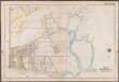
Plate 31: [Bounded by Avenue V., Knapp Street, Avenue W., E. 30th Street, Avenue X., Gerristen Avenue, Avenue W., Knapp Street, Avenue V., Bragg Street, (Sheepstead Bay) Emmons Avenue, Ocean Avenue and Neck Road.]; Atlas of the borough of Brooklyn, city of New York: from actual surveys and official plans by George W. and Walter S. Bromley.
from Atlas of the borough of Brooklyn, city of New York : from actual surveys and official plans by George W. and Walter S. Bromley. G.W. Bromley & Co.,
Brooklyn, Vol. 3, Double Page Plate No. 4; Part of Ward 32, Section 23; [Map bounded by Avenue K, Ralph Ave., Avenue O, Flatbush Ave.; Including Flatlands Ave., E. 37th St., Avenue E, E. 38th St., Hubbard PL., E. 40th St.]; Sub Plan; [Map bounded by A...
From Volume 3
Plate 27: [Bounded by Ocean Avenue, Emmons Avenue, Neptune Avenue, Coney Island Avenue, Canal Avenue, Hubbard Street, Avenue X., Ocean Parkway and Avenue U.]; Atlas of the borough of Brooklyn, city of New York: from actual surveys and official plans by George W. and Walter S. Bromley.
from Atlas of the borough of Brooklyn, city of New York : from actual surveys and official plans by George W. and Walter S. Bromley. G.W. Bromley & Co.,
Brooklyn, Vol. 7, Double Page Plate No. 14; Part of Ward 31, Section 20; [Map bounded by E 27th St., Avenue S; Including E. 18th St., Avenue O]
from Ward 31.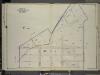
Brooklyn, Vol. 7, Double Page Plate No. 15; Part of Wards 31 & 32, Section 20; [Map bounded by Burnett St., Avenue S; Including E. 27th St., Avenue P]
from Ward 31.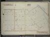
Brooklyn, Vol. 7, Double Page Plate No. 16; Part of Ward 31, Section 22; [Map bounded by Avenue S, Avenue U; Including E. 27th St.]
from Ward 31.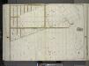
Brooklyn, Vol. 3, Double Page Plate No. 22; Part of Ward 31, Section 22; [Map bounded by Avenue S., Gerristen Ave.; Including Avenue U, Avenue X, Ocean Ave.] / by and under the direction of Hugo Ullitz.
From Volume 3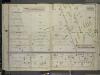
Brooklyn, Vol. 7, Double Page Plate No. 17; Part of Ward 31, Section 22; [Map bounded by E. 27th St., Avenue W; Including E. 18th St., Avenue S]
from Ward 31.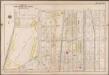
Plate 25: [Bounded by Avenue Q., Ocean Avenue, Avenue U. and Gravesend Avenue.]; Atlas of the borough of Brooklyn, city of New York: from actual surveys and official plans by George W. and Walter S. Bromley.
from Atlas of the borough of Brooklyn, city of New York : from actual surveys and official plans by George W. and Walter S. Bromley. G.W. Bromley & Co.,
Brooklyn, Vol. 7, Double Page Plate No. 42; Part of Ward 31, Section 22; [Map bounded by Gerritsens Creek, Avenue X; Including Bragg St., Avenue U]; Sub Plan No. 1; [Map bounded by Avenue U, Burnett St.]; Sub Plan No. 2; [Map bounded by Gerritsens C
from Ward 31.
Plate 24: [Bounded by Avenue M., Coney Island Avenue, Elm Avenue, Bay Avenue, Cedar Avenue, Ocean Avenue, Avenue Q. and Gravesend Avenue.]; Atlas of the borough of Brooklyn, city of New York: from actual surveys and official plans by George W. and Walter S. Bromley.
from Atlas of the borough of Brooklyn, city of New York : from actual surveys and official plans by George W. and Walter S. Bromley. G.W. Bromley & Co.,
Brooklyn V. 15, Plate No. 71 [Map bounded by Gerritsen Ave., Avenue S, Avenue T]
From Atlas 101. Vol. 15, 1907.
Brooklyn, Vol. 7, Double Page Plate No. 41; Part of Ward 31, Section 22; [Map bounded by Bragg St., Avenue Y; Including E. 27th St., Avenue U]
from Ward 31.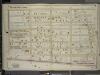
Brooklyn, Vol. 7, Double Page Plate No. 18; Part of Ward 31, Section 22; [Map bounded by E. 18th St., Avenue W; Including Coney Island Ave., Avenue S]
from Ward 31.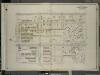
Brooklyn, Vol. 7, Double Page Plate No. 4; Part of Ward 31 & 32, Section 20; [Map bounded by Ocean Ave., Avenue M; Including E. 13th St., Avenue J]
from Ward 31.
Area District Map Section No. 23; Area district map / City of New York, Board of Estimate and Apportionment.
from Area district map / City of New York, Board of Estimate and Apportionment. New York (N.Y.). Board of Estimate and Apportionment,
Use District Map Section No. 23; Use district map / City of New York, Board of Estimate and Apportionment.
from Use district map / City of New York, Board of Estimate and Apportionment. New York (N.Y.). Board of Estimate and Apportionment,
Height District Map Section No. 23; Height district map / City of New York, Board of Estimate and Apportionment.
from Height district map / City of New York, Board of Estimate and Apportionment. New York (N.Y.). Board of Estimate and Apportionment,
29A - N.Y. City (Aerial Set).
from Sectional aerial maps of the City of New York / [photographed and assembled under the direction of the chief engineer, July 1st, 1924].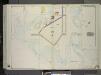
Brooklyn, Vol. 3, Double Page Plate No. 37; Part of Ward 32, Section 25; [Map bounded by Avenue U, E. 68th St., Avenue Z; Including Bushes Meadow, Ryder St., Avenue X] / by and under the direction of Hugo Ullitz.
From Volume 3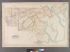
Plate 27: [Bounded by Avenue U, Gerritsen Avenue, Avenue U, Marsh Street, Avenue V, E. 35th Street, Avenue W, Ryder Street, Avenue X, Gerritsen Avenue, Avenue W, Knapp Street, Avenue V, Bragg Street, Emmons Avenue, Ford Street, Voorhies Avenue, Batchelde
from Robinson's atlas of Kings County, New York : compiled from official records ... / under the direction of E. Robinson.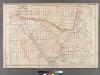
Plate 25: [Bounded by Avenue C, Ralph Avenue, Avenue L, Ocean Avenue, Avenue E, Avenue D and E. 31st Street.
from Robinson's atlas of Kings County, New York : compiled from official records ... / under the direction of E. Robinson.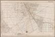
Plate 33: [Bounded by Avenue J., E. 56th Street, Fillmore Avenue, Kimball Street, Avenue R., E. 35th Street, Avenue Q., E. 31st Street, Avenue P. and Ocean Avenue.]; Atlas of the borough of Brooklyn, city of New York: from actual surveys and official plans by George W. and Walter S. Bromley.
from Atlas of the borough of Brooklyn, city of New York : from actual surveys and official plans by George W. and Walter S. Bromley. G.W. Bromley & Co.,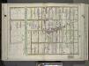
Brooklyn, Vol. 3, Double Page Plate No. 8; Part of Ward 31, Section 20; [Map bounded by Avenue O, Ocean Ave.; Including Avenue S, E. 2nd St.] / by and under the direction of Hugo Ullitz.
From Volume 3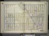
Brooklyn, Vol. 3, Double Page Plate No. 2; Part of Ward 32, Section 23; [Map bounded by Glenwood Road, E. 14th St., Avenue K; Including Flatbush Ave., Ocean Ave.] / by and under the direction of Hugo Ullitz.
From Volume 3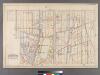
![Plate 26: [Bounded by Avenue L. Ralph Avenue, E. 61st Street, Avenue U, Ryder Street, Avenue W, E. 33rd Street, Avenue V, Burnett Street, Avenue U, Gerritsen Avenue, Avenue U and Ocean Avenue.]](https://images-2.georeferencer.com/images/iiif/653942798373/full/,300/0/native.jpg)

