Maps of Kings County
General map of the borough of Richmond (Staten Island) in the city of New York : showing in addition to the existing topographical features of the borough a tentative and preliminary plan for a street system of the same.
from Staten Island
Area District Map Section No. 28
from Area district map / City of New York, Board of Estimate and Apportionment.
Use District Map Section No. 28; Use district map / City of New York, Board of Estimate and Apportionment.
from Use district map / City of New York, Board of Estimate and Apportionment. New York (N.Y.). Board of Estimate and Apportionment,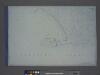
Height District Map Section No. 28; Height district map / City of New York, Board of Estimate and Apportionment.
from Height district map / City of New York, Board of Estimate and Apportionment. New York (N.Y.). Board of Estimate and Apportionment,
28C - N.Y. City (Aerial Set).
from Sectional aerial maps of the City of New York / [photographed and assembled under the direction of the chief engineer, July 1st, 1924].
Plate 20: [Bounded by Bay 46th Street, Harway Avenue, Avenue Z, Stillwell Avenue and (Atlantic Ocean) Surf Avenue.]
from Robinson's atlas of Kings County, New York : compiled from official records ... / under the direction of E. Robinson.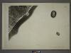
27D - N.Y. City (Aerial Set).
from Sectional aerial maps of the City of New York / [photographed and assembled under the direction of the chief engineer, July 1st, 1924].
28A - N.Y. City (Aerial Set).
from Sectional aerial maps of the City of New York / [photographed and assembled under the direction of the chief engineer, July 1st, 1924].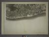
28D - N.Y. City (Aerial Set).
from Sectional aerial maps of the City of New York / [photographed and assembled under the direction of the chief engineer, July 1st, 1924].
Plate 18:[Bounded by 86th Street, W. 12th Street, Avenue V, Stillwell Avenue, Bay 46th Street, Warehouse Avenue, 20th Street, Cropsey Avenue and De Bruyen's Lane.]
from Robinson's atlas of Kings County, New York : compiled from official records ... / under the direction of E. Robinson.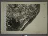
27B - N.Y. City (Aerial Set).
from Sectional aerial maps of the City of New York / [photographed and assembled under the direction of the chief engineer, July 1st, 1924].
Part of Ward 4. [Map bound by Scott Ave, Old Town Road, South Field Beach Rail Road, New Creek, Liberty Ave, South Side Boulevard, Evergreen Ave]
from Atlas of the city of New York, borough of Richmond, Staten Island. From actual surveys and original plans, by George W. and Walter S. Bromley.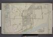
Part of Ward 4. [Map bound by Fingerboard Road, Tompkins Ave, Lyman Ave, New York Ave, Richmond Ave, Sea Ave, Seaside Boulevard, Old Town Road]
from Atlas of the borough of Richmond, city of New York.
Part of Southfield.
from Atlas of Staten Island, Richmond County, New York, from official records and surveys; compiled and drawn by F. W. Beers.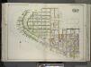
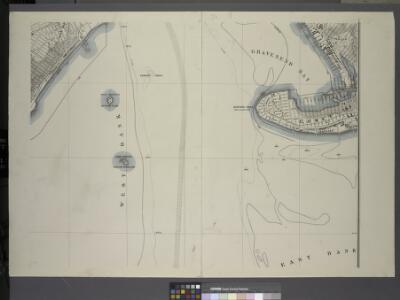
Brooklyn, Vol. 3, Double Page Plate No. 14; Part of Ward 31, Section 21; [Map bounded by Gravesend Bay, W. 35th St., Canal Ave.; Including W. 29th St., Atlantic Ocean] / by and under the direction of Hugo Ullitz.
From Volume 3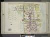
Brooklyn, Vol. 3, Double Page Plate No. 15; Part of Ward 31, Section 21; [Map bounded by Stillwell Ave., Atlantic Ocean, W. 29th St.; Including Canal Ave., Warehouse Ave., Avenue Z] / by and under the direction of Hugo Ullitz.
From Volume 3
Part of Ward 4. [Map bound by Richmond Ave, Sea Ave (Sand), Seaside Boulevard, Lower New York Bay, Staten Island Rapid Transit Rail Road, Sand Ave (Lane), Old Town Road]
from Atlas of the city of New York, borough of Richmond, Staten Island. From actual surveys and original plans, by George W. and Walter S. Bromley.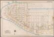
Plate 28: [Bounded by Bay View Avenue, W. 37th Street, (Gravesend Bay) Canal Avenue, W. 23rd Street, Surf Avenue, (Atlantic Ocean) Atlantic Avenue, Surf Avenue, Poplar Avenue and Seagate Avenue.]; Atlas of the borough of Brooklyn, city of New York: from actual surveys and official plans by George W. and Walter S. Bromley.
from Atlas of the borough of Brooklyn, city of New York : from actual surveys and official plans by George W. and Walter S. Bromley. G.W. Bromley & Co.,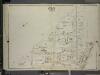
Brooklyn, Vol. 7, Double Page Plate No. 24; Part of Ward 31, Section 21; [Map bounded by Stillwell Ave.; Including Harway Ave., 26th Ave.]
from Ward 31.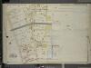
Brooklyn, Vol. 7, Double Page Plate No. 23; Part of Ward 31, Sections 19 & 21; [Map bounded by 26th Ave., Warehouse Ave.; Including 23rd Ave., Bath Ave.]
from Ward 31.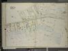
Brooklyn, Vol. 7, Double Page Plate No. 25; Part of Ward 31, Section 21; [Map bounded by W. 15th St., Canal Ave., Warehouse Ave.; Including 26th Ave., Harway Ave., Bay 46th St.]
from Ward 31.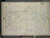
Brooklyn, Vol. 7, Double Page Plate No. 21; Part of Ward 31, Section 21; [Map bounded by W. 6th St., Avenue Y; Including Stillwell Ave., Avenue U]
from Ward 31.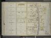
Brooklyn, Vol. 7, Double Page Plate No. 28; Part of Ward 31, Section 21; [Map bounded by W. 23rd St., Atlantic Ocean; Including W. 32nd St., Canal Ave.]
from Ward 31.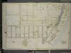
Brooklyn, Vol. 7, Double Page Plate No. 27; Part of Ward 31, Section 21; [Map bounded by W. 32nd St., Atlantic Ocean, Beach 40th St.; Including Surf Ave., Seagate Ave., Bay View Ave., Gravesend Bay, Canal Ave.]; Sub Plan; [Map bounded by Se
from Ward 31.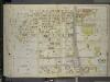
Brooklyn, Vol. 7, Double Page Plate No. 29; Part of Ward 31, Section 21; [Map bounded by Stillwell Ave., Atlantic Ocean; Including W. 33rd St., Canal Ave.]
from Ward 31.
Staten Island, V. 1, Plate No. 72 [Map bounded by Richmond Ave., Sand Lane, Agnes Pl., Pearsall]
From Atlas 162. Vol. 1, 1917.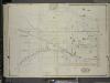
Brooklyn, Vol. 7, Double Page Plate No. 31; Part of Ward 31, Section 21; [Map bounded by W. 6th St., W. 8th St., Neptune Ave.; Including Stillwell Ave., W. 15th St., Canal Ave., Avenue Y]
from Ward 31.
Brooklyn Vol. B Plate No. 14 [Map bounded by W.16th St., Neptune Ave., W.12th St., Mermaid Ave.]
From Atlas 62. Suppl., 1905.
Brooklyn Vol. B Plate No. 174 [Map bounded by W.17th St., Mermaid Ave., Atlantic Ocean]
From Atlas 62. Vol. B, 1895.