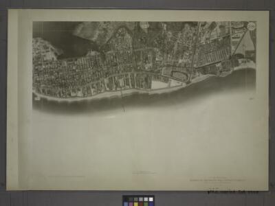
Maps of Kings County
28D - N.Y. City (Aerial Set).
from Sectional aerial maps of the City of New York / [photographed and assembled under the direction of the chief engineer, July 1st, 1924].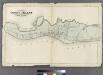
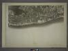
Map of Coney Island, New York.
from Atlas of the entire city of Brooklyn, complete in one volume. From actual surveys and official records by G. W. Bromley & Co.
Plate 20: [Bounded by Bay 46th Street, Harway Avenue, Avenue Z, Stillwell Avenue and (Atlantic Ocean) Surf Avenue.]
from Robinson's atlas of Kings County, New York : compiled from official records ... / under the direction of E. Robinson.
Plate 19: Part of Section 21 - Coney Island.
from Atlas of the borough of Brooklyn, city of New York : from actual surveys and official plans by George W. and Walter S. Bromley.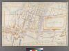
Part of Coney Island, Town of Gravesend.
from Robinson's atlas of Kings County, New York : compiled from official records ... / under the direction of E. Robinson.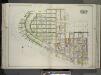
Brooklyn, Vol. 3, Double Page Plate No. 14; Part of Ward 31, Section 21; [Map bounded by Gravesend Bay, W. 35th St., Canal Ave.; Including W. 29th St., Atlantic Ocean] / by and under the direction of Hugo Ullitz.
From Volume 3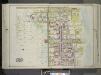
Brooklyn, Vol. 3, Double Page Plate No. 15; Part of Ward 31, Section 21; [Map bounded by Stillwell Ave., Atlantic Ocean, W. 29th St.; Including Canal Ave., Warehouse Ave., Avenue Z] / by and under the direction of Hugo Ullitz.
From Volume 3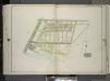
Brooklyn, Vol. 3, Double Page Plate No. 19; Part of Ward 31, Section 21; [Map bounded by Neptune Ave.; Including Atlantic Ocean, Ocean Parkway] / by and under the direction of Hugo Ullitz.
From Volume 3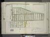
Brooklyn, Vol. 3, Double Page Plate No. 20; Part of Ward 31, Section 22; [Map bounded by Neptune Ave., Shore Blvd., Oxford St.; Including Atlantic Ocean]; Sub Plan No. 1; [Map bounded by Shore Blvd.; Including Oxford St.]; Sub Plan No. 2; [Map bounde...
From Volume 3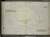
Brooklyn, Vol. 7, Double Page Plate No. 35; Part of Ward 31, Section 22; [Map bounded by Neptune Ave., Emmons Ave.; Including Atlantic Ocean]; Sub Plan; [Map bounded by Sheepshead Bay, Atlantic Ocean]
from Ward 31.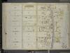
Brooklyn, Vol. 7, Double Page Plate No. 28; Part of Ward 31, Section 21; [Map bounded by W. 23rd St., Atlantic Ocean; Including W. 32nd St., Canal Ave.]
from Ward 31.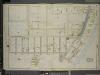
Brooklyn, Vol. 7, Double Page Plate No. 27; Part of Ward 31, Section 21; [Map bounded by W. 32nd St., Atlantic Ocean, Beach 40th St.; Including Surf Ave., Seagate Ave., Bay View Ave., Gravesend Bay, Canal Ave.]; Sub Plan; [Map bounded by Se
from Ward 31.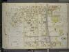
Brooklyn, Vol. 7, Double Page Plate No. 29; Part of Ward 31, Section 21; [Map bounded by Stillwell Ave., Atlantic Ocean; Including W. 33rd St., Canal Ave.]
from Ward 31.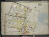
Brooklyn, Vol. 7, Double Page Plate No. 30; Part of Ward 31, Section 21; [Map bounded by E. 5th St., Atlantic Ocean, Stillwell Ave.; Including Neptune Ave., W. 8th St., Sheephead Road]
from Ward 31.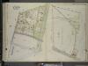
Brooklyn, Vol. 7, Double Page Plate No. 34; Part of Ward 31, Section 21; [Map bounded by Sheepshead Bay Road, Ocean Parkway; Including Atlantic Ocean, W. 5th St.]; Sub Plan; [Map bounded by Sheepshead Bay Road, E. 5th St., Seabreeze Ave., C
from Ward 31.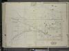
Brooklyn, Vol. 7, Double Page Plate No. 31; Part of Ward 31, Section 21; [Map bounded by W. 6th St., W. 8th St., Neptune Ave.; Including Stillwell Ave., W. 15th St., Canal Ave., Avenue Y]
from Ward 31.
Brooklyn Vol. B Plate No. 184 [Map bounded by Atlantic Ocean, Sea Breeze Ave., Coney Island Ave.]
From Atlas 62. Vol. B, 1895.
Brooklyn Vol. B Plate No. 14 [Map bounded by W.16th St., Neptune Ave., W.12th St., Mermaid Ave.]
From Atlas 62. Suppl., 1905.
Brooklyn Vol. B Plate No. 174 [Map bounded by W.17th St., Mermaid Ave., Atlantic Ocean]
From Atlas 62. Vol. B, 1895.
Brooklyn Vol. B Plate No. 15 [Map bounded by W.16th St., W.12th St., Neptune Ave.]
From Atlas 62. Suppl., 1905.
Brooklyn Vol. B Plate No. 179 [Map bounded by Canal Ave., Coney Island Creek, Cortland St., Sheepshead Bay Road]
From Atlas 62. Vol. B, 1895.
Brooklyn Vol. B Plate No. 175 [Map bounded by Stillwell Ave., Overton Place, W. 10th St.]
From Atlas 62. Vol. B, 1895.
Brooklyn Vol. B Plate No. 193 [Map bounded by E. 16th St., Voorhies Ave., E. 19th St., Sheepshead Bay]
From Atlas 62. Vol. B, 1895.
Brooklyn Vol. B Plate No. 182 [Map bounded by Sheepshead Bay Road, Ocean Parkway, Sea Breeze Ave.]
From Atlas 62. Vol. B, 1895.
Brooklyn Vol. B Plate No. 178 [Map bounded by Sheepshead Bay Road, W.5th St., Surf Ave.]
From Atlas 62. Vol. B, 1895.
Brooklyn Vol. B Plate No. 176 [Map bounded by W. 10th St., Surf Ave., Atlantic Ocean]
From Atlas 62. Vol. B, 1895.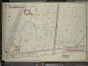
Brooklyn, Vol. 7, Double Page Plate No. 36; Part of Ward 31, Sections 21 & 22; [Map bounded by Avenue Z, E. 13th St.; Including Sheepshead Bay Road, Ocean Parkway]
from Ward 31.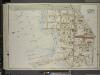
Brooklyn, Vol. 7, Double Page Plate No. 33; Part of Ward 31, Section 21; [Map bounded by Ocean Parkway, Sheepsheadbay Road, W. 8th St.; Including Shell Road, Coney Island Creek, Avenue Z]
from Ward 31.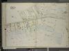
Brooklyn, Vol. 7, Double Page Plate No. 25; Part of Ward 31, Section 21; [Map bounded by W. 15th St., Canal Ave., Warehouse Ave.; Including 26th Ave., Harway Ave., Bay 46th St.]
from Ward 31.