Maps of Wayne County

Red Creek [Village]; Red Creek Business Notices.
from Atlas of Wayne County, New York : from actual surveys and official records / compiled & published by D. G. Beers & Co.
Cayuga County.
1 : 151000 Burr, David H., 1803-1875
Oswego County.
1 : 151000 Burr, David H., 1803-1875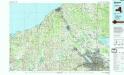
Syracuse
1 : 100000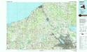
Syracuse
1 : 100000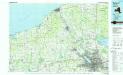
Syracuse
1 : 100000
Map of the county of Monroe / by David H. Burr; engd. by Rawdon, Clark & Co., Albany, & Rawdon, Wright & Co., N.Y.; An atlas of the state of New York: containing a map of the state and of the several counties / by David H. Burr.
from An atlas of the state of New York : containing a map of the state and of the several counties / by David H. Burr. Burr, David H.; Rawdon, Clark & Co.; Rawdon, Wright & Co.; Stone & Clark Republishers,
Map of the county of Monroe / by David H. Burr; engd. by Rawdon, Clark & Co., Albany, & Rawdon, Wright & Co., New York.; An atlas of the state of New York: containing a map of the state and of the several counties. / Projected and drawn under the superintendence and direction of Simeon de Witt ... And also the physical geography of the State ...
from An atlas of the state of New York : containing a map of the state and of the several counties. / Projected and drawn under the superintendence and direction of Simeon de Witt ... And also the physical geography of the State ... Burr, David H.; De Witt, Simeon,
Wayne, Ontario, Yates, Seneca counties.
1 : 158400 Bien, Joseph Rudolf
Oswego, Cayuga, Onondaga counties.
1 : 158400 Bien, Joseph Rudolf
Map of the counties of Ontario & Yates / by David H. Burr ; engd. by Rawdon, Clark & Co., Albany, & Rawdon, Wright & Co., N.Y.
from An atlas of the state of New York, designed for the use of engineers, containing a map of the state and of the several counties. / Projected and drawn ... under the superintendence and direction of Simeon de Witt.
Oswego County.
from Atlas of New York.
Rochester
1 : 250000
Rochester
1 : 250000
Rochester
1 : 250000
Rochester
1 : 250000
Rochester
1 : 250000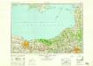
Rochester
1 : 250000
Map of the county of Cayuga / by David H. Burr ; engd. by Rawdon, Clark & Co., Albany, & Rawdon, Wright & Co., N.Y.
from An atlas of the state of New York : containing a map of the state and of the several counties / by David H. Burr.
"Onondaga, Cortland, Broome, Madison, and Chenango Counties"
from New topographical atlas and gazetteer of New York, comprising a topographical view of the several counties of the state, ... including ... map of the United States and territories ... Compiled from the latest astronomical observations, official surveys and records of the United States and territories ...
Map of the state of New York.
from Whole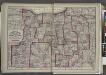
"Monroe, Livingston, Allegany, Wayne, Ontario, Steuben, Yates, Schuyler, Chemung, Seneca, Cayuga, Tompkins, Tioga, Onondaga, and Cortland Counties "
from New topographical atlas and gazetteer of New York, comprising a topographical view of the several counties of the state, ... including ... map of the United States and territories ... Compiled from the latest astronomical observations, official surveys and records of the United States and territories ...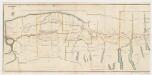
A new map and profile of the proposed canal from Lake Erie to Hudson River in the state of New York : Western sheet
1 : 253440 New York (State). Canal Commissioners W. A. Mercein, printer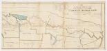
A new map and profile of the proposed canal from Lake Erie to Hudson River in the state of New York : Eastern sheet
1 : 253440 New York (State). Canal Commissioners W. A. Mercein, printer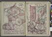
"Jefferson, Oswego, and Lewis Counties"
from New topographical atlas and gazetteer of New York, comprising a topographical view of the several counties of the state, ... including ... map of the United States and territories ... Compiled from the latest astronomical observations, official surveys and records of the United States and territories ...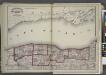
"Niagara, Orleans, Genesee, Monroe, and Wayne counties"
from New topographical atlas and gazetteer of New York, comprising a topographical view of the several counties of the state, ... including ... map of the United States and territories ... Compiled from the latest astronomical observations, official surveys and records of the United States and territories ...
A new map and profile of the proposed canal from Lake Erie to Hudson River in the State of New York / contracted by direction of the Canal Commissioners from the maps of the engineers 1821.
from Erie Canal
Map of the route of the proposed New York & Erie Railroad, as surveyed in 1834 / reduced from the plans as returned by Benjn. Wright, Civil Engineer ; D. R. Harrison, sc.
From Whole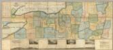
Map of the Western Part of the State Of New York.
1 : 330000 Vance, David H.
![Red Creek [Village]; Red Creek Business Notices.](https://images-2.georeferencer.com/images/iiif/373929187122/full/,300/0/native.jpg)

