Maps of Finger Lakes

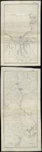
Map of the country embracing the several routes examined with a view to a national road from Washington to Lake Ontario
1 : 332000 Harrison, F. Harrison, F.
Pennsylvania (Eastern Part).
1 : 585000 Hammond, C.S.
Pennsylvania.
1 : 539000 Rand McNally and Company
Map of the canals and rail roads for transporting anthracite coal from the several coal fields to the city of New York
1 : 322000 Lorenz, William Hunckel & Son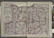
"Monroe, Livingston, Allegany, Wayne, Ontario, Steuben, Yates, Schuyler, Chemung, Seneca, Cayuga, Tompkins, Tioga, Onondaga, and Cortland Counties "
from New topographical atlas and gazetteer of New York, comprising a topographical view of the several counties of the state, ... including ... map of the United States and territories ... Compiled from the latest astronomical observations, official surveys and records of the United States and territories ...
A Map Of The State Of Pennsylvania.
1 : 310000 Howell, Reading
Map of Pennsylvania / constructed from the county surveys authorized by the state, and other original documents ; revised and improved under the supervision of Wm. E. Morris, civil engineer, upon data procured in each county ; engraved by Edwd. Yeager.
From Whole
The new war map of Maryland, part of Virginia & Pennsylvania
1 : 520000 Russell, B. B. (Benjamin B.)
Seat of war in the environs of Philadelphia / by Thos. Kitchin Senr., hydrographer to His Majesty.
from Revolutionary War, 1775-1783
Map of the state of New York.
from Whole
Maryland and Delaware.; The cerographic atlas of the United States. By Sidney E. Morse, A.M., and Samuel Breese, A.M.
from Supplement to the New York observer. Morse, Sidney E. (Sidney Edwards); Breese, Samuel,
Map of the Seat of War: Washington, Baltimore, Harper's Ferry and Annapolis
Map of the Seat of War: Washington, Baltimore, Harper's Ferry and Annapolis L. Prang & Co.
Map of the county of Cayuga / by David H. Burr ; engd. by Rawdon, Clark & Co., Albany, & Rawdon, Wright & Co., N.Y.
from An atlas of the state of New York : containing a map of the state and of the several counties / by David H. Burr.
Strategic War Points of the United States no.1: Country Road Washington
Strategic War points of the United States: Country Road Washingon J. Wyld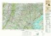
Baltimore
1 : 250000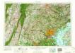
Baltimore
1 : 250000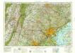
Baltimore
1 : 250000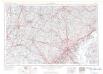
Baltimore
1 : 250000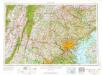
Baltimore
1 : 250000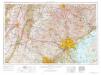
Baltimore
1 : 250000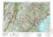
Baltimore
1 : 250000
Baltimore
1 : 250000
Baltimore
1 : 250000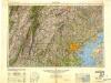
Baltimore
1 : 250000
Baltimore
1 : 250000
Harrisburg
1 : 250000
Harrisburg
1 : 250000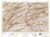
Harrisburg
1 : 250000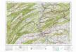
Harrisburg
1 : 250000
Harrisburg
1 : 250000
Harrisburg
1 : 250000
Harrisburg
1 : 250000
Harrisburg
1 : 250000
Harrisburg
1 : 250000
Harrisburg
1 : 250000