Maps of New Jersey

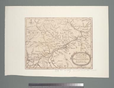
Seat of war in the environs of Philadelphia / by Thos. Kitchin Senr., hydrographer to His Majesty.
from Revolutionary War, 1775-1783
Bacon's topographical war map showing the battle fields of Pennsylvania, Maryland, and Virginia
1 : 540000 G.W. Bacon & Co. G.W. Bacon & Co.
Map of the state of Maryland : laid down from an actual survey of all the principal waters, public roads, and divisions of the counties therein : describing the situation of the cities, towns, villages, houses of worship and other public buildings, fu...
From Maryland
A Map of the country round Philadelphia: including part of New Jersey, New York, Staten Island, & Long Island.; The Gentleman's magazine.
from The Gentleman's magazine. The Gentleman's magazine,
The legacy of New Sweden: Swedish and Finnish sites in America, 1638-1787 / compiled by Richard Hulan.
Richard Hulan,
A map of the roads leading to the town of Britania in the British settlement, Susquehanna County, Penna. / drawn by H.S. Tanner; T.V.K. & Co. sc.
from Cities and towns, A - Z Henry S. Tanner,
Map of The State of New Jersey
from Atlas of Monmouth co., New Jersey. From recent and actual surveys and records, under the superintendence of F.W. Beers.
New Jersey.
1 : 860000 Schonberg & Co.
Map of the State of New Jersey
from Atlas of Hunterdon County, New Jersey : from recent and actual surveys and records / under the superintendence of F.W. Beers.
[Neueste Karte von New Jersey mit seinen Strassen, Entfernungen der Hauptpunkte und Routen für Dampfschiffe]
Grosser Hand-Atlas über alle Theile der Erde in 170 Karten Meyer, J. Verlag des Bibliographischen Instituts
New Jersey.
1 : 1000000 Finley, Anthony
New Jersey.
1 : 980000 Lucas, Fielding Jr.
New Jersey.
1 : 1100000 Tanner, Henry S.
New Jersey.
1 : 778000 Tanner, Henry S.
New Jersey.
1 : 570000 Rand McNally and Company
New Jersey.
1 : 1077120 Scott, Joseph
The province of New Jersey, divided into east and west, commonly called the Jerseys
1 : 430000 Faden, William Perrier et Verrier
New Jersey.
1 : 750000 Colton, G.W.
New Jersey.
1 : 475200 Colton, G.W.
New Jersey.
1 : 1060000 Lucas, Fielding Jr.
Shell Highway Map of New Jersey.
1 : 427680 Shell Oil Company
New Jersey.
1 : 750000 Colton, G.W.
New Jersey.
1 : 750000 Colton, G.W.
New Jersey.
1 : 778000 Mitchell, Samuel Augustus
New Jersey.
1 : 778000 Mitchell, Samuel Augustus
New Jersey.
1 : 190000 Tanner, Henry S.
New Jersey.
1 : 760320 Colton, J. H.
N.J. state map.
1 : 316800 Vermeule, C. C. (Cornelius Clarkson), 1858-1950
N.J. relief map.
1 : 316800 Vermeule, C. C. (Cornelius Clarkson), 1858-1950