Maps of Queens County
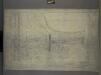
M-T-10-113: [Bounded by West 85th Street, West 86th Street, West 87th Street, West 88th Street and (Receiving Reservoir) Bridle Path.]
from Topographical survey of portion of Central Park, Boro. of Manhattan ... / City of New York, Department of Parks, Topographical Division.
Part of Section 4 : Plate 95.
from Atlas of the borough of Manhattan, city of New York.
Plate 9, Part of Section 4: [Bounded by W. 89th Street, Central Park West, W. 83rd Street and Amsterdam Avenue.]
from Atlas of the city of New York, borough of Manhattan. From actual surveys and official plans / by George W. and Walter S. Bromley.
M-T-10-111: [Bounded by West 89th Street, West 90th Street, West 91st Street, West 92nd Street and (Receiving Reservoir) Bridle Path.]
from Topographical survey of portion of Central Park, Boro. of Manhattan ... / City of New York, Department of Parks, Topographical Division.
M-T-10-115: [Bounded by West 81st Street, West 82nd Street, West 83rd Street, West 84th Street and Bridle Path.]
from Topographical survey of portion of Central Park, Boro. of Manhattan ... / City of New York, Department of Parks, Topographical Division.
Plate 9, Part of Section 4: [Bounded by W. 89th Street, Central Park West, W. 83rd Street and Amsterdam Avenue.]
from Atlas of the city of New York, borough of Manhattan. From actual surveys and official plans / by George W. and Walter S. Bromley.
Manhattan, V. 7, Plate No. 16 [Map bounded by W. 91st St., Central Park West, W. 86th St., Columbus Ave.]
From Atlas 120. Vol. 7, 1902.
Manhattan, V. 7, Plate No. 12 [Map bounded by W. 86th St., Central Park West, W. 81st St., Columbus Ave.]
From Atlas 120. Vol. 7, 1902.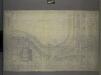
M-T-10-114: [Bounded by Bridle Path (Receiving Reservoir), East 88th Street, East 87th Street, East 86th Street and East 85th Street.]
from Topographical survey of portion of Central Park, Boro. of Manhattan ... / City of New York, Department of Parks, Topographical Division.
M-T-10-112: [Bounded by Bridle Path (Receiving Reservoir), East 92nd Street, East 91st Street, East 90th Street and East 89th Street.]
from Topographical survey of portion of Central Park, Boro. of Manhattan ... / City of New York, Department of Parks, Topographical Division.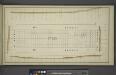
[Block No. 572 Map bounded by 88th Street, 5th Avenue, 87th Street, 6th Avenue]
from Maps & profiles of ground for new reservoir situated between 86th and 96th streets and between 5th and 7th avenues.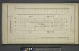
[Block No. 678 Map bounded by 92nd Street, 6th Avenue, 91st Street, 7th Avenue]
from Maps & profiles of ground for new reservoir situated between 86th and 96th streets and between 5th and 7th avenues.
Manhattan, V. 7, Plate No. 65 [Map bounded by Central Park West, 5th Ave.]
From Atlas 120. Vol. 7, 1902.
Part of Wards 12 & 22, New York City.
from Atlas of the city of New York : embracing all territory within its corporate limits from official records, private plans & actual surveys / by and under the supervision of E. Robinson & R.H. Pidgeon, civil engineers.
Sackersdorff Farm set.
from Sackersdorf Farm Set.
Sackersdorff Farm set.
from Maps of farms commonly called the Blue book, 1815 : drawn from the original on file in the street commissioner's office in the City of New York, together with lines of streets and avenues / laid out by John Randel, jr., 1819-20.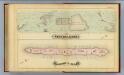
41. Central Park, Blackwells Island.
1 : 6000 G.W. Bromley & Co.; Geo. W. Bromley & E. Robinson
25. Wards 12, 22.
1 : 2400 G.W. Bromley & Co.; Geo. W. Bromley & E. Robinson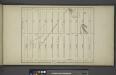
[Map bounded by 7th Avenue, 96th Street, 5th Avenue, 86th Street; Including 87th Street, 88th Street, 89th Street, 90th Street, 91th Street, 92th Street, 93th Street, 94th Street, 95th Street, 6th Avenue]
from Maps & profiles of ground for new reservoir situated between 86th and 96th streets and between 5th and 7th avenues.
Page 16: [Bounded by W. 114th Street, Fourth (Park) Avenue, (Spanish Harlem) E. 94th Street (Carnegie Hill) and Eighth Avenue.]
from Sackersdorf Farm Set.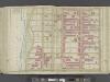
Manhattan, Double Page Plate No. 36 [Map bounded by W. 97th St., Central Park W., W. 86th St., Hudson St.,]
From Atlas of the city of New York, Manhattan Island. From actual surveys and official plans
[Plate 36: Bounded by W. 97th Street, Central Park West, W. 86th Street, and [Hudson River, Riverside Park] Riverside Drive.]
from Atlas of the city of New York, borough of Manhattan. From actual surveys and official plans / by George W. and Walter S. Bromley.
Plate 36: Bounded by W. 97th Street, Central Park West, W. 86th Street, and (Hudson River) Riverside Drive.
from Atlas of the city of New York, Manhattan Island. From actual surveys and official plans / by George W. and Walter S. Bromley.
Manhattan, V. 7, Plate No. 64 [Map bounded by Central Park West, 5th Ave.]
From Atlas 120. Vol. 7, 1902.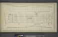
[Block No. 579 Map bounded by 95th Street, 5th Avenue, 94th Street, 6th Avenue]
from Maps & profiles of ground for new reservoir situated between 86th and 96th streets and between 5th and 7th avenues.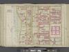
Manhattan, Double Page Plate No. 26 [Map bounded by W. 86th St., Central Park W., W. 75th St., Hudson River]
From Atlas of the city of New York, Manhattan Island. From actual surveys and official plans
Part of Section 4 : New York City.
from Atlas of the city of New York, borough of Manhattan. From actual surveys and official plans / by George W. and Walter S. Bromley.
[Plate 26: Bounded by W. 86th Street, Central Park West (8th Avenue), W. 75th Street and Hudson River.]
from Atlas of the city of New York, Manhattan Island. From actual surveys and official plans / by George W. and Walter S. Bromley.
[Plate 97: Bounded by W. 95th Street, Central Park West, W. 89th Street, and Amsterdam Avenue.]
from Atlas of the borough of Manhattan, city of New York.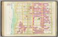
![M-T-10-113: [Bounded by West 85th Street, West 86th Street, West 87th Street, West 88th Street and (Receiving Reservoir) Bridle Path.]](https://images-2.georeferencer.com/images/iiif/699124775823/full/,300/0/native.jpg)

