Maps of Queens County

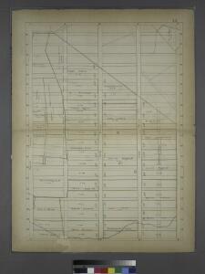
Sackersdorff Farm set.
from Maps of farms commonly called the Blue book, 1815 : drawn from the original on file in the street commissioner's office in the City of New York, together with lines of streets and avenues / laid out by John Randel, jr., 1819-20.
Manhattan V. 7, Plate No. 55 [Map bounded by Columbus Ave., Cathedral Parkway, Central Park West, W. 108th St.]
From Atlas 121. Vol. 7, pt. 1, 1912.
41. Central Park, Blackwells Island.
1 : 6000 G.W. Bromley & Co.; Geo. W. Bromley & E. Robinson
Manhattan, V. 7, Plate No. 64 [Map bounded by Central Park West, 5th Ave.]
From Atlas 120. Vol. 7, 1902.
[Map bounded by 7th Avenue, 96th Street, 5th Avenue, 86th Street; Including 87th Street, 88th Street, 89th Street, 90th Street, 91th Street, 92th Street, 93th Street, 94th Street, 95th Street, 6th Avenue]
from Maps & profiles of ground for new reservoir situated between 86th and 96th streets and between 5th and 7th avenues.
Manhattan, V. 7, Plate No. 65 [Map bounded by Central Park West, 5th Ave.]
From Atlas 120. Vol. 7, 1902.
Manhattan, Double Page Plate No. 30 [Map bounded by 5th Ave., E. 97th St., 2nd Ave., E. 80th St.]
From Atlas of the city of New York, Manhattan Island. From actual surveys and official plans
[Plate 30: Bounded by Fifth Avenue, E. 97th Street, Second Avenue, and E.83rd Street.]
from Atlas of the city of New York, borough of Manhattan. From actual surveys and official plans / by George W. and Walter S. Bromley.
Part of Secions 5 & 6.
from Atlas of the city of New York, Manhattan Island. From actual surveys and official plans / by George W. and Walter S. Bromley.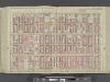
Manhattan, Double Page Plate No. 28 [Map bounded by 5th Ave., E. 80th St., 2nd Ave., E. 64th St.]
From Atlas of the city of New York, Manhattan Island. From actual surveys and official plans
[Plate 28: Bounded by Fifth Avenue, E. 80th Street, Second Avenue, and E. 64th Street.]
from Atlas of the city of New York, borough of Manhattan. From actual surveys and official plans / by George W. and Walter S. Bromley.
[Plate 28: Bounded by Fifth Avenue, E. 80th Street, Second Avenue, and E. 84th Street.]
from Atlas of the city of New York, Manhattan Island. From actual surveys and official plans / by George W. and Walter S. Bromley.
21. Ward 19.
1 : 2400 G.W. Bromley & Co.; Geo. W. Bromley & E. Robinson
Part of Section 5: Plate 112.
from Atlas of the borough of Manhattan, city of New York.
Part of Section 5: Plate 114.
from Atlas of the borough of Manhattan, city of New York.
Part of Section 4 : Plate 95.
from Atlas of the borough of Manhattan, city of New York.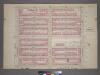
Plate 9, Part of Section 4: [Bounded by W. 89th Street, Central Park West, W. 83rd Street and Amsterdam Avenue.]
from Atlas of the city of New York, borough of Manhattan. From actual surveys and official plans / by George W. and Walter S. Bromley.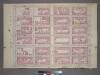
Plate 29, Part of Section 5: [Bounded by E. 83rd Street, Third Avenue, E. 77th Street and Fifth Avenue.]
from Atlas of the city of New York, borough of Manhattan. From actual surveys and official plans / by George W. and Walter S. Bromley.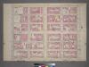
Plate 30, Part of Section 5: [Bounded by E. 89th Street, Third Avenue, E. 83rd Street and Fifth Avenue.]
from Atlas of the city of New York, borough of Manhattan. From actual surveys and official plans / by George W. and Walter S. Bromley.
Plate 9, Part of Section 4: [Bounded by W. 89th Street, Central Park West, W. 83rd Street and Amsterdam Avenue.]
from Atlas of the city of New York, borough of Manhattan. From actual surveys and official plans / by George W. and Walter S. Bromley.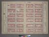
Plate 29, Part of Section 5: [Bounded by E. 83rd Street, Third Avenue, E. 77th Street and (Central Park) Fifth Avenue.]
from Atlas of the city of New York, borough of Manhattan. From actual surveys and official plans / by George W. and Walter S. Bromley.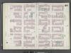
Manhattan, V. 8, Double Page Plate No. 155 [Map bounded by E. 78th St., 3rd Ave., E. 72nd St., 5th Ave.]
From Atlas 122. Vol. 8, 1896.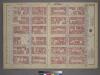
Plate 30, Part of Section 5: [Bounded by E. 89th Street, Third Avenue, E. 83rd Street and (Central park) Fifth Avenue.]
from Atlas of the city of New York, borough of Manhattan. From actual surveys and official plans / by George W. and Walter S. Bromley.
Manhattan, V. 8, Double Page Plate No. 156 [Map bounded by E. 83rd St., 3rd Ave., E. 78th St., 5th Ave.]
From Atlas 122. Vol. 8, 1896.
Manhattan, V. 8, Double Page Plate No. 157 [Map bounded by E. 88th St., 3rd Ave., E. 83rd St., 5th Ave.]
From Atlas 122. Vol. 8, 1896.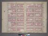
Plate 24, Part of Section 5: [Bounded by E. 77th Street, Third Avenue, E.71st Street and Fifth Avenue.]
from Atlas of the city of New York, borough of Manhattan. From actual surveys and official plans / by George W. and Walter S. Bromley.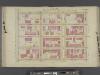
Manhattan, V. 6, Double Page Plate No. 18 [Map bounded by E. 94th St., Lexington Ave., E. 90th St., 5th Ave.] / compiled from official records and actual surveys under the direction of E. Robinson and Roger H. Pidgeon.
From Vol. 6
M-T-10-117: [Bounded by Central Park West, Transverse Road No. 2 and West Drive.]
from Topographical survey of portion of Central Park, Boro. of Manhattan ... / City of New York, Department of Parks, Topographical Division.
M-T-10-119: [Bounded by West 74th Street, West 75th Street, West 76th Street, West Drive, and The Lake.]
from Topographical survey of portion of Central Park, Boro. of Manhattan ... / City of New York, Department of Parks, Topographical Division.