Maps of Queens County
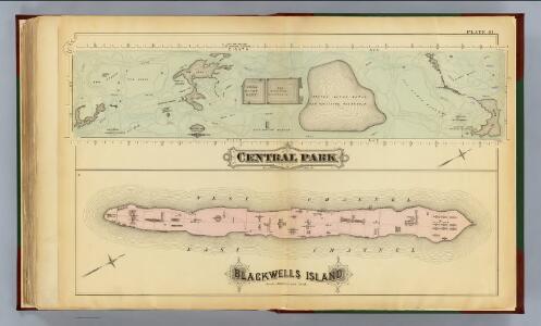
41. Central Park, Blackwells Island.
1 : 6000 G.W. Bromley & Co.; Geo. W. Bromley & E. Robinson
Sackersdorff Farm set.
from Maps of farms commonly called the Blue book, 1815 : drawn from the original on file in the street commissioner's office in the City of New York, together with lines of streets and avenues / laid out by John Randel, jr., 1819-20.
Manhattan V. 7, Plate No. 55 [Map bounded by Columbus Ave., Cathedral Parkway, Central Park West, W. 108th St.]
From Atlas 121. Vol. 7, pt. 1, 1912.
25. Wards 12, 22.
1 : 2400 G.W. Bromley & Co.; Geo. W. Bromley & E. Robinson
Sackersdorff Farm set.
from Sackersdorf Farm Set.
Part of Wards 12 & 22, New York City.
from Atlas of the city of New York : embracing all territory within its corporate limits from official records, private plans & actual surveys / by and under the supervision of E. Robinson & R.H. Pidgeon, civil engineers.
Manhattan, V. 7, Plate No. 64 [Map bounded by Central Park West, 5th Ave.]
From Atlas 120. Vol. 7, 1902.
Manhattan, Double Page Plate No. 36 [Map bounded by W. 97th St., Central Park W., W. 86th St., Hudson St.,]
From Atlas of the city of New York, Manhattan Island. From actual surveys and official plans
[Plate 36: Bounded by W. 97th Street, Central Park West, W. 86th Street, and [Hudson River, Riverside Park] Riverside Drive.]
from Atlas of the city of New York, borough of Manhattan. From actual surveys and official plans / by George W. and Walter S. Bromley.
[Block No. 579 Map bounded by 95th Street, 5th Avenue, 94th Street, 6th Avenue]
from Maps & profiles of ground for new reservoir situated between 86th and 96th streets and between 5th and 7th avenues.
Plate 36: Bounded by W. 97th Street, Central Park West, W. 86th Street, and (Hudson River) Riverside Drive.
from Atlas of the city of New York, Manhattan Island. From actual surveys and official plans / by George W. and Walter S. Bromley.
Manhattan, V. 7, Plate No. 65 [Map bounded by Central Park West, 5th Ave.]
From Atlas 120. Vol. 7, 1902.
Manhattan, Double Page Plate No. 26 [Map bounded by W. 86th St., Central Park W., W. 75th St., Hudson River]
From Atlas of the city of New York, Manhattan Island. From actual surveys and official plans
Part of Section 4 : New York City.
from Atlas of the city of New York, borough of Manhattan. From actual surveys and official plans / by George W. and Walter S. Bromley.
Manhattan, Double Page Plate No. 28 [Map bounded by 5th Ave., E. 80th St., 2nd Ave., E. 64th St.]
From Atlas of the city of New York, Manhattan Island. From actual surveys and official plans
[Plate 26: Bounded by W. 86th Street, Central Park West (8th Avenue), W. 75th Street and Hudson River.]
from Atlas of the city of New York, Manhattan Island. From actual surveys and official plans / by George W. and Walter S. Bromley.
[Plate 37: Bounded by W. 108th Street, Central Park West, W. 97th Street and (Hudson River) Riverside Drive.]
from Atlas of the city of New York, Manhattan Island. From actual surveys and official plans / by George W. and Walter S. Bromley.
[Plate 28: Bounded by Fifth Avenue, E. 80th Street, Second Avenue, and E. 64th Street.]
from Atlas of the city of New York, borough of Manhattan. From actual surveys and official plans / by George W. and Walter S. Bromley.
[Plate 28: Bounded by Fifth Avenue, E. 80th Street, Second Avenue, and E. 84th Street.]
from Atlas of the city of New York, Manhattan Island. From actual surveys and official plans / by George W. and Walter S. Bromley.
[Plate 37: Bounded by W. 108th Street, Central Park West, W. 97th Street, and [Hudson River, Riverside Park] Riverside Drive.]
from Atlas of the city of New York, borough of Manhattan. From actual surveys and official plans / by George W. and Walter S. Bromley.
Manhattan, Double Page Plate No. 37 [Map bounded by W. 108th St., Central Park W., W. 97th St., Hudson River]
From Atlas of the city of New York, Manhattan Island. From actual surveys and official plans
Pl. 36: ward 12.
1 : 1800 Bromley, George Washington; Bromley, Walter Scott
[Plate 99: Bounded by W. 100th Street, Central Park West, W. 95th Street, and Amsterdam Avenue.]
from Atlas of the borough of Manhattan, city of New York.
Part of Section 4 : Plate 95.
from Atlas of the borough of Manhattan, city of New York.
[Plate 97: Bounded by W. 95th Street, Central Park West, W. 89th Street, and Amsterdam Avenue.]
from Atlas of the borough of Manhattan, city of New York.
Part of Sections 4 & 7 : Plate 98.
from Atlas of the borough of Manhattan, city of New York.
Part of Section 4 : Plate 93.
from Atlas of the borough of Manhattan, city of New York.
Plate 8, Part of Section 4: [Bounded by W. 83rd Street, Central Park West, W. 77th Street and Amsterdam Avenue.]
from Atlas of the city of New York, borough of Manhattan. From actual surveys and official plans / by George W. and Walter S. Bromley.
Plate 9, Part of Section 4: [Bounded by W. 89th Street, Central Park West, W. 83rd Street and Amsterdam Avenue.]
from Atlas of the city of New York, borough of Manhattan. From actual surveys and official plans / by George W. and Walter S. Bromley.