Maps of Manhattan Community Board 9

Outline and Index Map, Sections 9 and 10, Borough of the Bronx.
from Atlas and owners names, borough of the Bronx, sections 9 & 10 : from actual surveys and official plans / by George W. and Walter S. Bromley.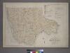
Outline and Index Map of the 23rd Ward, City of New York.
from Atlas of the city of New York : from official records, private plans & actual surveys / compiled under the supervision of E. Robinson & R. H. Pidgeon.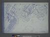
Use District Map Section No. 6
from Use district map / City of New York, Board of Estimate and Apportionment.
Front Cover
from Height district map / City of New York, Board of Estimate and Apportionment.
[Map of the city of New York and island of Manhattan as laid out by the commissioners appointed by the Legislature, April 3, 1807]
From Manhattan
Map and plan showing the street system in the 1st ward of the borough of Queens, formerly Long Island City.
From Queens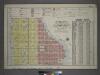
Outline and Index Map of Volume Four.
from Atlas of the city of New York, borough of Manhattan / from actual surveys and official plans by George W. and Walter S. Bromley.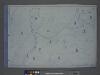
Area District Map Section No. 6; Area district map / City of New York, Board of Estimate and Apportionment.
from Area district map / City of New York, Board of Estimate and Apportionment. New York (N.Y.). Board of Estimate and Apportionment,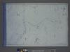
Height District Map Section No. 6; Height district map / City of New York, Board of Estimate and Apportionment.
from Height district map / City of New York, Board of Estimate and Apportionment. New York (N.Y.). Board of Estimate and Apportionment,
W. Farms, Morrisania.
1 : 15840 Beers, F. W. (Frederick W.)
Proposed Harlem River Drive from 155th Street to Dyckman River.
From Manhattan
Hell Gate and its approaches / from a trigonometrical survey under the direction of F.R. Hassler and A.D. Bache, superintendents of the Survey of the Coast of the United States.
from New York harbor
Use District Map Section No. 3; Use district map / City of New York, Board of Estimate and Apportionment.
from Use district map / City of New York, Board of Estimate and Apportionment. New York (N.Y.). Board of Estimate and Apportionment,
Height District Map Section No. 3; Height district map / City of New York, Board of Estimate and Apportionment.
from Height district map / City of New York, Board of Estimate and Apportionment. New York (N.Y.). Board of Estimate and Apportionment,
Area District Map Section No. 3; Area district map / City of New York, Board of Estimate and Apportionment.
from Area district map / City of New York, Board of Estimate and Apportionment. New York (N.Y.). Board of Estimate and Apportionment,
Bronx, Topographical Map Sheet 9; [Map bounded by Southern Blvd., Kingsbridge Road, Bronx River, Home St.; Including Westchester Ave., Intervale Ave., Stebbins Ave., Marion Ave.]
From Topographical map made from surveys by the commissioners of the Department of Public Parks of the City of New York of that part of Westchester County adjacent to the City and County of New York embraced by chapter 534 of laws of 1871 as amended b...
Bronx, Topographical Map Sheet 10; [Map bounded by Anderson Ave., Jerome Ave.; Including 7th Ave., 149th St., River St.]
From Topographical map made from surveys by the commissioners of the Department of Public Parks of the City of New York of that part of Westchester County adjacent to the City and County of New York embraced by chapter 534 of laws of 1871 as amended b...
6A - N.Y. City (Aerial Set).
from Sectional aerial maps of the City of New York / [photographed and assembled under the direction of the chief engineer, July 1st, 1924].
6B - N.Y. City (Aerial Set).
from Sectional aerial maps of the City of New York / [photographed and assembled under the direction of the chief engineer, July 1st, 1924].
6D - N.Y. City (Aerial Set).
from Sectional aerial maps of the City of New York / [photographed and assembled under the direction of the chief engineer, July 1st, 1924].
3C - N.Y. City (Aerial Set).
from Sectional aerial maps of the City of New York / [photographed and assembled under the direction of the chief engineer, July 1st, 1924].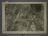
3D - N.Y. City (Aerial Set).
from Sectional aerial maps of the City of New York / [photographed and assembled under the direction of the chief engineer, July 1st, 1924].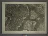
6C - N.Y. City (Aerial Set).
from Sectional aerial maps of the City of New York / [photographed and assembled under the direction of the chief engineer, July 1st, 1924].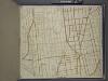
Bronx, Topographical Map Sheet 11; [Map bounded by Union Ave., Tinton Ave., Westchester Ave., Eacle Ave., St. Ann's Ave., Rae St., Cerman PL., Brook Ave., Bercen Ave., 3rd Ave.; Including 153rd St., Rail Road Ave. East, Sheridan Ave., Mott Ave., Walto...
From Topographical map made from surveys by the commissioners of the Department of Public Parks of the City of New York of that part of Westchester County adjacent to the City and County of New York embraced by chapter 534 of laws of 1871 as amended b...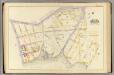
3, ward 23.
1 : 1800 Bromley, George Washington; Bromley, Walter Scott; G.W. Bromley & Co.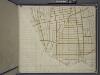
Bronx, Topographical Map Sheet 14; [Map bounded by 154th St., Grove St., Westchester Ave., Robbins Ave.; Including Powers Ave., Cypress Ave., Harlem River, 126th St., 6th Ave.]
From Topographical map made from surveys by the commissioners of the Department of Public Parks of the City of New York of that part of Westchester County adjacent to the City and County of New York embraced by chapter 534 of laws of 1871 as amended b...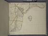
Bronx, Topographical Map Sheet 15; [Map bounded by 151 St., Southern Blvd., 149th St., Whitlock Ave., Wetmore Ave.; Including Edgewater Road, Cypress Ave., Powers Ave., Robbins Ave.]
From Topographical map made from surveys by the commissioners of the Department of Public Parks of the City of New York of that part of Westchester County adjacent to the City and County of New York embraced by chapter 534 of laws of 1871 as amended b...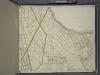
Bronx, Topographical Map Sheet 12; [Map bounded by Foote Ave., Maple Coster St., Maxwell Conover St., Wenman Ave., Randall Ave.; Including Wetmore Ave., Whitlock Ave., Southern Blvd., Fox St., Prospect Ave., Union Ave., Beck St.]
From Topographical map made from surveys by the commissioners of the Department of Public Parks of the City of New York of that part of Westchester County adjacent to the City and County of New York embraced by chapter 534 of laws of 1871 as amended b...
Sheet 18: [Bounded by 149th Street, (Harlem River,Bulk Head & Pier Lane), E. Hundred & Twenty Fourth Street.]
from Plan of New York City, from the Battery to Spuyten Duyvil Creek. Showing every lot and building thereon; old farm lines, strreet numbers at the corners of blocks, railroads, steamboat landings, bulkhead and pier lines, etc. Based on the surveys made by Messrs. Randall & Blackwell, and on the special survey by J. F. Harrison.


